


53 Hiking Trails near Fifth Water Hot Springs
first prev 1 2 3 next lastShowing Hiking Trails within 50 miles Distance miles of 3JMV+QW West Portal, UT, USA City, Zip, or Address

Dripping Rock
Spanish Fork, Utah
12.7 miles WDripping Rock is along a paved path adjacent to Spanish Oaks Golf Course.
Hike
Bicentennial Park
Provo, Utah
17.1 miles NWA 16-hole disc golf course in Provo beside a duck pond, a playground, a boardwalk nature trail with natural springs, and mature trees that make even moderate holes a genuine challenge.
Disc Golf, Hike, Sled
Y-Mountain Summit Trail
Provo, Utah
17.4 miles NWA 1.2-mile climb east of BYU leads to a massive block Y on the hillside and sweeping panoramas over Provo, Orem, Utah Valley, and Utah Lake below.
Camp, Hike
Grotto Falls
Payson, Utah
19.3 miles SWA gentle wooded creek trail with bridges leads to a waterfall and limestone grotto you can crawl around — all ages welcome and especially stunning in fall color season.
Hike
P Mountain and Little Mountain
Payson, Utah
20.1 miles WP Mountain and Little Mountain is Payson's hometown hike, a short, rewarding ridge walk in the Uinta-Wasatch-Cache National Forest that leads to the point above the giant white "P" overlooking town,...
Hike
Provo River Parkway Trail
Provo, Utah
22.0 miles NWA fully paved 6-mile canyon ride from Vivian Park to the mouth of Provo Canyon, passing waterfalls and a fish-feeding spot — best done with two cars for a car-shuttle downhill.
Hike, Mountain Bike
Timpanogos Falls
Provo, Utah
25.7 miles NWA lesser-known multi-tiered waterfall on the Mt. Timpanogos trail, visible early on and surrounded by wildflowers in late spring — a great beginner hike shared with the Stewart Falls trailhead.
Hike
Stewart Falls
Provo, Utah
25.7 miles NWA glacier-fed, 200-foot multi-tiered waterfall on Mt. Timpanogos — about a 4-mile round trip hike through forest with a few steep edges near the falls.
Hike 1.2 mi
Battle Creek Falls
Pleasant Grove, Utah
26.5 miles NWA short 1.2-mile family-friendly hike in Pleasant Grove to a scenic waterfall with views from below and above, plus a nearby rappelling and rock climbing area just beyond the falls.
Canyoneer, Hike
G Mountain Trail
Pleasant Grove, Utah
26.5 miles NWA family-friendly 1.5-mile roundtrip hike from Kiwanis Park to a hillside 'G' landmark near Pleasant Grove — a little steep at the start and the end, but great for all ages.
Hike
Grove Creek Trail
Pleasant Grove, Utah
27.4 miles NWA steep, shuttled downhill singletrack dropping from the shoulder of Mount Timpanogos through Grove Creek Canyon — the climb is brutal, but the descent is worth it.
Hike, Mountain Bike 1.6-14.1 mi
Mount Timpanogas
Provo, Utah
28.2 miles NWUtah's most-climbed mountain towers 7,000 feet above the Provo valley, stretching seven miles north to south with multiple peaks over 11,000 feet — a Wasatch landmark.
Camp, Hike, Horseback, Swim 1.5 mi
Timpanogas Cave
Provo, Utah
30.9 miles NWColorful cave formations — cave bacons, columns, flowstone, and drapery — inside a Timpanogos mountain cave, reached by a 1.5-mile paved trail; tours run May through September.
Backpack, Cave, Hike
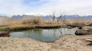
Saratoga Hot Springs
Saratoga Springs, Utah
34.2 miles NWThree naturally heated pools around 100°F year-round, a muddy beautiful setting, and an easy walk to nearby Utah Lake for wildlife watching between soaks.
Hike, Hot Springs 1.7 mi
Schoolhouse Springs Trail
Alpine, Utah
34.8 miles NWA short, scenic trail at 5,300 feet in Alpine, Utah, featuring a lake and activities from horseback riding to hiking — best enjoyed between May and October.
Hike, Mountain Bike
White Pine Lake
Sandy, Utah
35.9 miles NWA canyon that ski resort lobbyists fought to keep out of wilderness, now open to hikers and rare mountain bikers — hike in and discover why everyone has been arguing over White Pine Canyon.
Hike, Mountain Bike
American Fork Twin Peaks
Provo, Utah
36.0 miles NWA high-elevation, intermediate-friendly peak scramble that doubles as a gateway to multi-summit ridge traverses — offering sweeping views over Snowbird ski resort from the alpine ridge.
Hike
Sugarloaf Peak
Alta, Utah
36.2 miles NWAn easily reached 11,000-foot Wasatch summit overlooking Albion Basin, Secret Lake, and Alta ski resort — one of the easiest of the Wasatch 11ers with a high trailhead and gentle terrain.
Hike
Cecret (Secret) Lake
Alta, Utah
36.4 miles NWA short, easy alpine hike through Albion Basin meadows in Little Cottonwood Canyon leads to a beautiful mountain lake everyone can enjoy.
Hike
Mercer Hollow Trail
Draper, Utah
36.7 miles NWA fast, flowy descent on the southern flank of Corner Canyon Ridge, packed with berms, rock features, rollers, and a quick uphill that rewards you on the way back down.
Hike, Mountain Bike


