


34 Hiking Trails near Hell's Half Acre Northbound Rest Stop
first prev 1 2 next lastShowing Hiking Trails within 50 miles Distance miles of US-26, Blackfoot, ID 83221, USA City, Zip, or Address
Hell's Half Acre Southbound Rest Stop
Blackfoot, Idaho
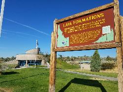
0.2 miles NA well-maintained Interstate 15 rest stop on a lava flow area with a great walking path, informational signs about the formations and wildlife, picnic tables, and vending machines.
Hike
Firth River Bottoms
Firth, Idaho
3.6 miles EA community riverside park in Firth with horseback riding, picnicking, fishing, and baseball — something for the whole family along the river bottoms.
Camp, Canoe, Hike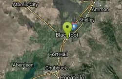
Blackfoot, ID 83221, United States
Blackfoot, Idaho
8.7 miles SWHike and Mountain Bike near Blackfoot, Idaho
Hike, Mountain Bike 0.1 mi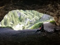
40 Horse Cave
Firth, Idaho
16.2 miles EA short, steep scramble near Firth to a roomy hillside cave — big enough, legend says, to hide 40 horses.
Cave, Hike
17 Mile Cave
Idaho Falls, Idaho
17.1 miles NA lava tube just 17 miles from Idaho Falls with a nearly flat quarter-mile tunnel ending in two cool pools — easy for beginners, though expect graffiti on the walls.
Cave, Hike 1.0-7.5 mi
Idaho Falls Greenbelt
Idaho Falls, Idaho
17.6 miles NEA 6-mile paved riverside trail through the heart of Idaho Falls past a 22-foot waterfall that stretches 600 feet wide, historic landmarks, parks, and downtown restaurants.
Hike 0.9 mi

Hell's Half Acre Lava Walk
Blackfoot, Idaho
19.4 miles NWTwo lava trails — a quick half-mile loop or a 4.5-mile route to the main vent — trace a 4,100-year-old 222-square-mile eruption across the Snake River Plain.
Hike 0.2-9.7 mi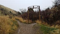
City Creek
Pocatello, Idaho
32.4 miles SPocatello's city-maintained trail network packs over six miles of singletrack into City Creek Canyon, with everything from casual loops to a downhill-only expert run.
Hike, Horseback, Mountain Bike 2.1-2.3 mi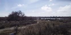
Market Lake Wildlife Management Area
Roberts, Idaho
33.1 miles NA wildlife management area teeming with waterfowl — ibis colonies, ducks, geese, herons, eagles, hawks, and owls — plus mule deer, white-tailed deer, and a small moose population near Roberts, Idaho.
Hike, Horseback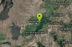
Sportsman's Park American Falls Reservoir
Aberdeen, Idaho
35.5 miles SWA 30-acre multi-use park on the American Falls Reservoir with two boat ramps, picnic shelters, RV hookups, playgrounds, volleyball courts, and a 1.1-mile paved trail along the reservoir rim.
Camp, Canoe, Hike
Lorenzo Boat Ramp
Rigby, Idaho
35.7 miles NEHike and Kayak near Rigby, Idaho
Hike, Kayak 1.0-1.3 mi
Lorenzo Bridge
Rexburg, Idaho
35.9 miles NEA quiet former boat launch with primitive riverside trails, a hidden lake, stunning fall colors, and a natural paintball field bounded by river and dry creek bed.
Airsoft, Hike, Paintball 0.6-2.0 mi
North Menan Butte ('R' Mountain)
Menan, Idaho
36.1 miles NEA volcanic butte locals call R Mountain, with a paved trailhead, chain handrails near the top, informational signs at the rim, and views of Rexburg and the Snake River.
Camp, Cave, Hike
Slate Mountain/Gibson Jack Trail
Pocatello, Idaho
36.2 miles SA beautiful Gibson Jack loop in Pocatello with aspen, pines, sage, and meadow views — clockwise is the preferred direction, but watch for a steep creek-bottom fork at mile 5 that can sink a tire.
Hike, Horseback, Mountain Bike 0.3-0.6 mi
Cress Creek Nature Trail
Rexburg, Idaho
36.9 miles NEA 1.25-mile self-guided nature trail along the South Fork of the Snake River through sagebrush, juniper slopes, and lush creekside habitat — with an overlook trail, caves near the rim, and moose sightings.
Hike 3.8 mi
Stinking Springs
Ririe, Idaho
37.6 miles NEAn ATV and dirt bike trail that doubles as a mountain bike gem — progressively bermed switchbacks, rock rolls, and gardens lead to connections with Kelly Canyon and the broader Big Hole range.
Hike, Mountain Bike 3.2 mi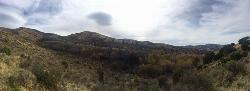
Kinney Creek Trail
Pocatello, Idaho
38.0 miles SA 6.4-mile out-and-back to Indian Mountain Summit in Caribou-Targhee National Forest near Pocatello, with Idaho backcountry views and exceptional birdwatching — raptors, waterfowl, and songbirds.
Hike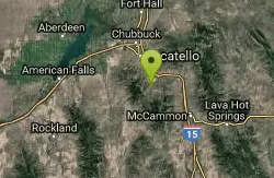
Cherry Springs
Pocatello, Idaho
38.6 miles SThick green vegetation, abundant birds, and wildlife viewing along a picnic-table-lined trail just a short distance from Pocatello, Idaho — a peaceful nature escape close to town.
Hike 3.8 mi
Kelly Mountain Trail
Ririe, Idaho
40.3 miles NEA moderate uphill trail open to hikers, mountain bikers, and ATVs, winding through hills with wildflower and mountain views — dogs welcome on leash.
Cross-country Ski, Hike, Mountain Bike, Snowshoe
Poison Flats
Ririe, Idaho
40.7 miles NEHike near Ririe, Idaho
Hike


