


92 Hiking Trails near Observation Point Trail
first prev 1 2 3 4 5 next lastShowing Hiking Trails within 50 miles Distance miles of Yellowstone National Park, 725 Old Faithful Lodge Rd, Yellowstone National Park, WY 82190, USA City, Zip, or Address
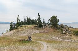
Storm Point Trail
Lake Village, Yellowstone National Park
25.6 miles EStorm Point Trail is a beautiful 2.3 mile hike that can be completed in under 2 hours. This is an easy hike with very little elevation change that is perfect for families with children. Hikers on...
Hike 2.4 mi
Cascade Lake Trail
Canyon Village, Yellowstone National Park
26.3 miles NECascade Lake Trail is an easy, short hike through picturesque meadows to the beautiful cascade lake. The trailhead is located North of Canyon Village on Grand Loop Road. There is a pullout here where...
Hike 7.6 mi
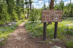
Observation Peak Trail
Canyon Village, Yellowstone National Park
26.3 miles NEObservation Peak Trail is one of the most famous hikes in Yellowstone National Park. The hike is an almost 10 miles there and back hike that starts and ends at the same trailhead. Observation...
Hike 5.8 mi
Box Canyon Trail
Island Park, Idaho
28.0 miles WVarious species of tress and wildflowers can be seen on the trail, as well as songbirds, waterfowl and occasional wildlife. The trail is open for the following uses: Motorcycle Trail Riding, Off...
Hike, Mountain Bike 3.4 mi
Dunraven Pass - Mount Washburn Trail
Canyon Village, Yellowstone National Park
29.0 miles NEHikers looking for a scenic hike to the peak Mount Washburn will be pleased hiking the Mount Washburn Trail via Dunraven Pass. This trail winds through quiet forests to the peak. The trailhead for...
Hike 16.3 mi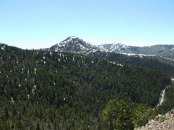
Mount Washburn Spur Trail
Canyon Village, Yellowstone National Park
30.3 miles NEWashburn Spur Trail is an exciting 8-mile trail connecting the peak of Mount Washburn to Seven Mile Hole Trail near Canyon Village. Hikers typically hike the trail starting at Mount Washburn and...
Hike 4.4 mi
Chittenden Road - Mount Washburn Trail
Canyon Village, Yellowstone National Park
30.4 miles NEHiking Mount Washburn via Chittenden Road is the shortest and easiest route to the top. The trail was once a service road and is now a clear well packed trail with a steady, gradual incline. The...
Hike
Mesa Falls
Ashton, Idaho
31.1 miles SWUpper Mesa Falls, aka Big Falls, is an absolutely awesome waterfall on the Henrys Fork of the Snake River. The falls drop 114 ft. and measure 300 ft. across. To get to the falls from the parking lot...
Cross-country Ski, Hike, Kayak 7.6 mi
Mount Jefferson
Island Park, Idaho
31.1 miles WMount Jefferson, at 10, 203 feet is the highest point in the Centennial Mountains, a small, local range on the border of Idaho and Montana a little west of Yellowstone. These mountains consist of a...
Hike 4.2 mi
Lake Marie
Island Park, Idaho
31.1 miles WLake Marie sits on the North slope of Mount Jefferson in Fremont County, Idaho. The trail to get there cuts back and forth across the Idaho Montana border 4 times. Much of the trail is fairly flat...
Backpack, Hike 0.3-0.6 mi
Bear Gulch
Ashton, Idaho
31.2 miles SWBear Gulch is an abandoned ski hill out of operation since 1969. While the vegetation is beginning to take over, there's still some great sledding to be had. It's just far enough into the...
Camp, Cross-country Ski, Hike, Sled 0.6-4.7 mi
Harriman State Park
Island Park, Idaho
32.7 miles WHarriman State Park is found 38 miles from Yellowstone along Henry's Fork. This 11,000-acre wildlife refuge is open year round for most activities. In addition to having beautiful scenery and...
Cross-country Ski, Hike, Horseback, Mountain Bike, Snowshoe 7.8 mi
Osprey Falls Trail
Mammoth Hot Springs, Yellowstone National Park
33.0 miles NOsprey Falls Trail is an 8 mile out and back trail near Mammoth Hot Springs that provides hikers with a variety of stunning views, including ravines and a waterfall. Hikers begin this hike...
Hike 4.0 mi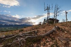
Bunsen Peak Trail
Mammoth Hot Springs, Yellowstone National Park
33.0 miles NBunsen Peak Trail is a 4.6 mile hike to the peak of Mount Bunsen. This is an out and back trail and is considered moderately difficult because of the 1,300 foot climb in elevation. ...
Hike 3.2-47.0 mi
Yellowstone Branch Line Trail
Ashton, Idaho
33.5 miles SWYellowstone branch line trail runs from Warm River to the Montana border totaling 39 miles. There are a few places to jump on and off the trail as well as a few smaller trails that branch off of this...
Backpack, Cross-country Ski, Hike, Horseback, Mountain Bike
Sheep Falls on Henry's Fork
Island Park, Idaho
33.5 miles SWSheep Falls cascades approximately 25' through a narrow basalt chute on the North Fork of the Snake River near Island Park, Idaho. Compared to nearby Lower and Upper Mesa Falls, that height may...
Hike 3.3 mi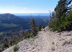
Avalanche Peak Trail
Cody, Wyoming
33.7 miles EAvalanche Peak Trail is a 4 mile trail to the peak of Avalanche Mountain. This is considered difficult because hikers will climb 2,100 feet in 2 miles. It is recommended that hikers bring...
Hike 0.8 mi
Wraith Falls Trail
Mammoth Hot Springs, Yellowstone National Park
34.8 miles NWraith Falls Trail is a less than 1 mile there and back hike that can be taken in under an hour. This is a wonderful family friendly hike that is easy for hikers of all levels. The hike leads...
Hike 2.0 mi
Snow Pass Trail
Yellowstone National Park Wyoming
35.0 miles NSnow Pass Trail is a beautiful day hike for visitors to Yellowstone looking to escape the crowds. Located a half mile south of the Mammoth Hot Springs Upper Terraces. Parking is available at a...
Backpack, Hike 5.3 mi
Beaver Ponds Trail
Mammoth, Yellowstone National Park
36.0 miles NBeaver Ponds Trail is a wonderful short hike accessible from Mammoth Hot Springs. The trail forms a loop between the two trailheads available at Mammoth Hot Springs. The loop is just over 5 miles...
Hike


