


Palisades Creek Trail / Lakes and Waterfall Canyon
Irwin, Idaho
4.4 miles E of Irwin, IdahoPalisades Creek Trail is located about 50 miles southeast of Idaho Falls and about 60 miles west of Jackson Hole WY in Swan Valley Idaho. The four mile hike up to lower Palisades Lake or the 6.2 mile hike to Upper Palisades Lake (elevation 6800 feet) provide some of the best mountain views in the Swan Valley region. Palisades Creek Trail is well maintained and can be used only by hikers, backpackers or horses as it is in the Palisades Wilderness Study area. If you choose to hike up to Upper Palisades Lake, two miles above Lower Palisades Lake you have to leave Palisades Creek trail and turn up Waterfall Canyon Trail and it is just a short distance up Waterfall Canyon. The upper lake typically has better camping because sites at the lower lake fill up sooner.
Both lakes were formed ages ago when giant landslides came down the canyon and blocked the creek. If you scan the mountain walls you may see mountain goats. It is 4 miles to the lower end of the lower lake.
Trail Map courtesy of SnakeRiverMountainBikeClub.com

Sheep Falls on Henry's Fork
Island Park, Idaho
15.6 miles S of Island Park, IdahoSheep Falls cascades approximately 25' through a narrow basalt chute on the North Fork of the Snake River near Island Park, Idaho. Compared to nearby Lower and Upper Mesa Falls, that height may not sound particularly spectacular but it is a pleasant hike on a relatively well maintained trail and is rarely crowded.

Pine Butte / The Caldera
St. Anthony, Idaho
21.7 miles N of St. Anthony, IdahoThis is about as close to an oasis as you can get in the deserts of Idaho. It's an old volcano in the middle of the sagebrush desert. As soon as you start down the path, you can feel the air change and the vegetation becomes that of a mountain forest. There are a ton of pine trees on the hillsides and a beautfiul meadow at the bottom surrounded by thick aspen trees. The bottom part of the sides nearly all the way around is covered with large boulders great for a little rock hiking if you care to explore. The path in is about as easy a hike as it gets. Maybe a little steep at points but it's only about a quarter mile down in. It's pretty small and there's a pretty established place for fires with plenty of dead wood scattered around.
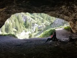
40 Horse Cave
Firth, Idaho
11.9 miles E of Firth, IdahoThe naming of the cave comes from a story of two men who were caught in a bad storm. Upon hiking, these two guys were able to find the cave. One of them commented to the other, "This cave could hold about 40 horses." Another legend tells of a theif that hid 40 horses in the cave to avoid capture. Either way, there's no doubt that 40 horses would fit in the cave.
The hike up to the cave is steep. Elevation gain may only be about 100 feet but even the longest trail is still just under 500 feet (0.1 mile) to the cave. Once you find the trailhead, it's really easy to find. You'll just hike uphill until you come to a large opening in the mountain. The shorter trail has a lot more shale and is a pretty difficult scramble. The longer trail is still steep and difficult but there is much less shale.
Flashlights aren't required, as the cave is only about 50 feet deep. There are a few corners of the cave that are a little more fun to explore with a flashlight.
At the bottom of the trail is a culvert and when the water is higher, it's a fun place to splash around after the hike. You'll see a trail in the willows on the SouthEast side of the road near the culvert. If you follow that trail only about 100 feet of easy hiking, you'll find a smaller cave.

Fall Creek Falls
Swan Valley, Idaho
2.1 miles SW of Swan Valley, IdahoFalls Campground is located next to the Snake River near beautiful Swan Valley, only 45 miles east of Idaho Falls, Idaho. Mixed growth cottonwood trees provide partial shade, and grassy meadows with summer wildflowers dot the area. Wildlife is plentiful in the river bottom; eagles, osprey, moose, and deer are frequently spotted. Fall Creek Falls is about 1/4 mile from the campground. The Snake River offers excellent trout fishing, canoeing, rafting, and kayaking. Spring Creek and Conant Boat Ramps, open to the public, are nearby. Palisades Reservoir is less than 20 miles from Falls Campground, with great boating, waterskiing, canoeing, fishing, and swimming.

Packsaddle Lake
Tetonia, Idaho
9.3 miles W of Tetonia, IdahoPacksaddle is one of the less well known lakes/trails in the area. If you've got a good offroad vehicle, you can probably make it all the way to the end of the road, otherwise, it's just an extra 0.5 miles up the hill. Even to get to that point though, you may push the limits of your car or mini van and be required to do some pretty technical driving. There are plenty of good spots to park along the road if you decide that's as far as you can drive. The descent to the lake is pretty steep (300ft elevation drop) but less than a 1/2 mile to the lake. You'll be able to see the lake from the top of the trail. There's a little camp area on the eastern edge of the lake.
Mountain Bike Trail (From Lower Trailhead)
It starts on a slight incline and then gets gradually steeper. Trail is pretty smooth. After a tough climb, you get a downhill followed by a field. Then there's a fork in the road. If you actually want to get to the lake, take a left at the fork. Climb some more. View the beautiful Tetons on your left. You'll come to a clearing at the top. If you look down to the left, the lake is between the trees down the steep decline singletrack. Don't ride right into the lake. It's freezing, and does a quick dropoff. Courtesy of Singletracks.com

Bear Creek Hot Springs
Irwin, Idaho
9.8 miles S of Irwin, Idaho
Darby Wind Cave
Driggs, Idaho
7.6 miles E of Driggs, IdahoDarby Wind Cave is a beautiful hike full of waterfalls, wildflowers, streams, and mountainous views. The sites you see will depend on the time of year you visit but it will always be beautiful and just a little bit of a challenge.
The trail starts out relatively flat, following along close to where the old road used to run. There are a few creek crossings which will vary in difficulty depending on how much snow there was over the winter and how long it's been since things began to thaw. Late summer will usually find you crossing dry or nearly dry creek beds. If you hike when runoff is high, there are log bridges. You don't have to be highwire ready but one of the bridges will take a little bit of balance. The trail turns up South up into the canyon. About as soon as it starts to go up, you'll turn and begin a series of switchbacks (10 turns). These will take you up the East wall of the canyon.
The switchbacks are not incredibly steep but you'll gain elevation pretty quickly. After the switchback, the trail follows along a rim above the canyon where you can look across the canyon and see two beautiful waterfalls and mouth of the cave seemingly high overhead. At the South end of the canyon, you'll come across a rock overhang. It's fun at any time during the summer but earlier when the water is higher, you'll find a little waterfall and stream that the kids will love to play in and you'll be hard pressed not to soak your head and feet and cool off a bit yourself.
From the the overhang, the hike continues West along the South end of the canyon through some more forest and a beautiful meadow. Take a minute to look up from the trail to enjoy the view of Fossil Peak to the South. Just after the meadow, you'll begin another series of switchbacks up to the falls and cave. The first set (2 turns) will take you up to a dispersed campsite and monument. The next leg will take you to the creek where you can look up and get photos of the falls and cave. The next set puts you out just underneath a very large and beautiful waterfall that drops out over a ledge. The ledge itself is a popular repel accessible from above. You can walk all the way around these falls and even catch some spray on the downwind side. The next set of switchbacks are stairs cut out of the rock. Halfway will take you to an even better view of Fossil Peak and the remainder will take you to the mouth of the cave itself. To enter the cave, you'll have to cross one more creek which can be pretty scary and dangerous when the water is high. Entering the cave during high water can be just as scary.
Once you're in, the Wind Cave snakes through the Darby Formation, a thick layer of 350 million year-old dolomite. A flashlight for the cave is a definite must. Near the mouth, there's a series of ledges popular for bouldering. Just up about 100 yards, you'll come to a small hole you'll have to crouch to get through. You'll quickly realize why they're called the wind caves as you're blasted with wind from the caves coming out that hole. After about 200 yards, you'll want your climbing gear. The caves stretch for miles and if you go far enough, you'll enter the part known as the ice caves. Travel far enough, you'll come out the other side. Be careful though. The cave becomes pretty cavelike and it's really easy to get lost and, even in the busy season, it may be days until that nightmare ends with a rescue team.
The hike is about 3.1 miles from the South Fork Darby Canyon trailhead to the caves and is a 1,800 feet elevation gain. You'll find a lot of resources that claim the hike is a shorter distance. These sources either begin from the end of the old road or don't take into account one or both series of switchbacks. The cave itself sits at 8,940 feet above sea level.

Ashton to Tetonia Trail
Ashton, Idaho
0.7 miles NE of Ashton, IdahoThe Idaho Department of Parks and Recreation undertook the project to transform the old Teton Valley Branch of the Union Pacific Railroad from Ashton to Tetonia into a trail for bikes, ATVs, and snowmobiles, runners, cross-country skiers, and horses. The trail goes from Ashton to Tetonia and can be accessed via Ashton, Marysville, Bitch Creek, Felt, or Tetonia. Information can be found at kiosks in Marysville and at Bitch Creek.
Elevation Gain (Southbound): 787 ft
Length: 29.6 mi

Aldous Lake and Hancock Lake
Kilgore, Idaho
7.7 miles N of Kilgore, IdahoA pair of alpine lakes near Kilgore, Idaho. Good road all the way to the trailhead. Easy to moderate 1.5mi hike to the first lake (Aldous) and another mile of moderate hiking to Hancock. Beautiful scenery, but heavier traffic on weekends.
Little Elk Creek Trail
Irwin, Idaho
9.1 miles SE of Irwin, Idaho
Box Canyon Trail
Island Park, Idaho
1.2 miles SW of Island Park, IdahoVarious species of tress and wildflowers can be seen on the trail, as well as songbirds, waterfowl and occasional wildlife. The trail is open for the following uses: Motorcycle Trail Riding, Off Highway Vehicles (OHV) less than or equal to 50 inches wide. source: fs.usda.gov Courtesy of Singletracks.com
This is a very scenic singletrack that can be ridden in either direction. There is not a lot of climbing but you get to enjoy beautiful views of the river as you follow it for the majority of the trail. The first part of the trail has a few spots that are rocky and can be a little harder to navigate through but this ends after about the first mile or so.Courtesy of MTBProject.com
This trail is a fly-fisherman’s dream, providing access to the trout-filled waters of Henry’s Fork of the Snake River. Beginning at the campground, the trail wanders south along Box Canyon’s rim for 3 miles, bringing hikers to the river after passing through a colorful wildflower landscape. Best months for hiking are June through September.Courtesy of ultimateidaho.com

Cave Falls of Yellowstone
Ashton, Idaho
22.9 miles E of Ashton, IdahoThis campgrond is situated on the banks of Fall River in Wyoming along the south border of Yellowstone National Park. Cave Falls Campground has 23 single site units and a terrific area for fishing. Each campsite has fire rings, grills and picnic tables. Located throughout the campground are vault toilets, water faucets, bear proof storage boxes, and a dumpster.
Bear Creek Campground at Palisades
Irwin, Idaho
7.0 miles SE of Irwin, IdahoPalisades Reservoir is ideal for water skiing in the summer and features many picnic spots and boat docks. The area forest service hosts nine campgrounds containing 181 family units. Boat launch ramps are located at convenient points along the reservoir at Blowout, Calamity, Indian Creek, Little Elk Creek, McCoy, and Upper Bear Creek. All have boat docks and campgrounds except Upper Bear Creek.

Devil's Stairs
Driggs, Idaho
10.1 miles E of Driggs, IdahoJust to the West of Table Rock is this often overlooked trail less traveled by, full of beautiful meadows and beautiful views all its own. The trail begins from the same campsite as the Table Rock trailhead but instead heads South. The trail starts at the Teton Canyon Trail Head and follows the Alaska Basin Trail South for 2.9 miles through beautiful mountain meadows and thickets of trees surrounded on either side by majestic mountains. At the fork, you'll turn West up the mountain. You'll find the biggest test of your climb as you ascend 1000 feet in about 2 miles of switchback trails. At the top of the switchbacks there is a small ledge, as if it was the edge of a large stair. Above that, you'll find a gorgeous meadow filled with wildflowers, beautiful trees, and a babbling brook all against the monumental backdrop of a towering cliff.
Distance: ~8 miles (round trip)

Alaska Basin
Driggs, Idaho
10.0 miles E of Driggs, IdahoThe Alaska Basin Trail is a stunning trail through the Jedediah Wilderness near Driggs, Idaho and goes East into Wyoming, just outside of Grand Teton National Park. The trail is wide and has easy terrain for the feet, but it is long, so it's best suited for intermediate to advanced hikers. There are spots on the trail where river crossing is necessary, so be prepared to rock hop, cross logs, or just get your feet wet.
Because the trail is in a wilderness area, rather than a National Park, no overnight camping permits are required; however, open fires are not allowed, so plan on bringing a camping stove. Carry bear spray and, if you are camping, plan on bear proofing your food and waste.
The trail features a variety of landscapes such as lush vegetation and wildflowers (peak season is July to August), rushing rivers and streams, the majestic Teton Mountain Range, and of course, the serene Alaska Basin. There is plenty of wildlife; black bears and moose both have been spotted on the trail. Enjoy their beauty, but please use precaution and respect their territory.

Table Rock / Table Mountain
Driggs, Idaho
10.0 miles E of Driggs, IdahoAt 11,300 feet, Table Mountain is possibly the most beautiful climb this side of the Tetons and offers what may well be the very best view of the Grand Tetons. It's just far enough away to be able to see all three peaks and close enough to make out all the detail.
There are 2 main trails with different distances but either way, you've got to climb over 4000 feet.
The Face trail is much steeper but also much shorter. It cuts out all of the switchbacks and 'B' lines it for the top. It's considerably shorter and you don't have to go very far before the view begins to open up and you can see the beauty of Teton Canyon and its surrounding peaks. (about 3.5 miles one way)
Huckleberry trail is much longer but also a much more gradual incline/decline. The trail follows and crosses North Fork Teton Creek making it a great spot to get a filtered water refill.It's not known as huckleberry for nothing. You just have to catch it at the right time (Mid-Late Summer depending on weather) and get to the bushes before everybody else picks them clean. (about 6.5 miles one way)
Check conditions via webcam at tetoncam.com.
Elevation: 11,300ft
Elevation Gain: 4000ft
Length: 7-13 miles

Horseshoe Lake
Ashton, Idaho
18.3 miles E of Ashton, IdahoHorseshoe Lake is hidden back in the Targhee National Forest. It's a beautiful lake with plenty of lily pads. The road to get there is well maintained and there are many options for pull-outs and parking once you get there. The lake has a gradual decline great for wading but has plenty deep enough for swimming and canoeing. A youth camp has a floating dock out towards the middle that is often free to use for jumping in. The lake is also a great place to go fishing. No motorized boats are allowed.

Firth River Bottoms
Firth, Idaho
0.7 miles W of Firth, IdahoWhether you like to ride horses, picnic, camp, fish, learn about the past, or play baseball, this park has something for everyone. The Parks & Recreation Department and the IDaho Education Alliance for Solutions (IDEAS) Board have given their valuable time, blood, sweat, and tears to improve the park.

Sheep Bridge Trail
Driggs, Idaho
6.7 miles NE of Driggs, IdahoThis is a great easy trail for beginner hikers or mountain bikers. In the early summer, you'll find many beautiful wildflowers and large kaleidoscopes of butterflies to go with them. You may want to wear bright colors and walk slowly to entice the butterflies to land on you. There's often a wide variety so may even want a book to identify them all.
The new trailhead is just off Teton Canyon Road and has parking for 15-20 vehicles. From there, you'll follow the trail about 0.25 miles south to Teton Creek where you'll cross a bridge. After crossing the bridge, you'll find a short uphill but after that, the ascent is minimal. The trail is pretty easy to follow as long as you keep right and keep heading East. Just short of halfway, there's a nice little spot where the trail forks left and you can go down and take a break at the creek. The entire trail runs about 2.25 miles, running parallel to Teton Creek and ending at a creek just short of Treasure Mountain Scout Camp. If you're on a bike, that's where it gets fun. Turn that bike around and enjoy some easy but fun downhill singletrack.


