


70 locations
Add Location
 Full Listing
Show more
Hike
Added on 5 Jul 2017
Full Listing
Show more
Hike
Added on 5 Jul 2017
 Full Listing
Show more
Rock Climb
Added on 3 Jul 2017
Full Listing
Show more
Rock Climb
Added on 3 Jul 2017
 Full Listing
Show more
Rock Climb
Added on 3 Jul 2017
Full Listing
Show more
Rock Climb
Added on 3 Jul 2017
 Full Listing
Show more
Rock Climb
Added on 3 Jul 2017
Full Listing
Show more
Rock Climb
Added on 3 Jul 2017
 Full Listing
Show more
Hike
Added on 3 Jul 2017
Full Listing
Show more
Hike
Added on 3 Jul 2017
 Full Listing
Show more
Hike
Added on 30 Jun 2017
Full Listing
Show more
Hike
Added on 30 Jun 2017
 Full Listing
Show more
Canoe, Hike
Added on 30 Jun 2017
Full Listing
Show more
Canoe, Hike
Added on 30 Jun 2017
 Full Listing
Show more
Backpack, Camp, Hike, Swim
Added on 26 Jun 2017
Full Listing
Show more
Backpack, Camp, Hike, Swim
Added on 26 Jun 2017
 Full Listing
Show more
Backpack, Camp, Swim
Added on 26 Jun 2017
Full Listing
Show more
Backpack, Camp, Swim
Added on 26 Jun 2017
 Full Listing
Show more
Camp, Canoe, Hike, Kayak, Swim
Added on 26 Jun 2017
Full Listing
Show more
Camp, Canoe, Hike, Kayak, Swim
Added on 26 Jun 2017
 Full Listing
Show more
Backpack, Hike
Added on 26 Jun 2017
Full Listing
Show more
Backpack, Hike
Added on 26 Jun 2017
 Full Listing
Show more
Swim
Added on 26 Jun 2017
Full Listing
Show more
Swim
Added on 26 Jun 2017
 Full Listing
Show more
Hike
Added on 23 Jun 2017
Full Listing
Show more
Hike
Added on 23 Jun 2017
 Full Listing
Show more
Backpack, Hike
Added on 19 Jun 2017
Full Listing
Show more
Backpack, Hike
Added on 19 Jun 2017
 Full Listing
Show more
Backpack, Hike
Added on 19 Jun 2017
Full Listing
Show more
Backpack, Hike
Added on 19 Jun 2017
 Full Listing
Show more
Backpack, Camp, Hike
Added on 16 Jun 2017
Full Listing
Show more
Backpack, Camp, Hike
Added on 16 Jun 2017
 Full Listing
Show more
Hike
Added on 16 Jun 2017
Full Listing
Show more
Hike
Added on 16 Jun 2017
1.4-4.6 mi
 Full Listing
Show more
Hike
Added on 28 Jun 2018
Full Listing
Show more
Hike
Added on 28 Jun 2018
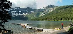
St Mary and Virginia Falls
Rising Sun, Glacier National Park
4.4 miles W of Rising Sun, Glacier National ParkVirginia Falls is one of two major waterfalls that feed into St Mary Lake. The trail is about 3.7 miles roundtrip, where visitors will see other waterfalls such as St Mary waterfall. The trail begins at the St Mary Falls trailhead on Going-to-the-Sun road, where there is a parking lot. Becasue there are multiple waterfalls in the area, this parking lot can get full very quickly, so it might be best to head out early in the morning or take a shuttle from Many Glacier.
An easy and scenic trail, visitors will go through the forest and past streams. St Mary Falls is a two tiered waterfall with a drop of over 50 ft. If tired, there are some nice spots to sit and catch a break, as well this point can make a good turn around point.
Virginia Falls is the next waterfall hikers will see. There is an upper portion of the falls and a lower portion. Both are beautiful to see. Like most waterfalls, the best time to see them is early in the season when the snowmelt is beginning and water is tumbling over the falls.
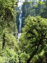
Munson Creek Falls
Tillamook, Oregon
7.1 miles SE of Tillamook, OregonThis park is home to several famous attractions along the Oregon Coast, including the tallest waterfall in the Coastal Range as well as several historic Western Red Cedar and Sitka Spruce. There are many hiking trails in the area, with the most popular being the trail to Munson Creek Falls. The hike itself is about .6 miles from the trailhead and weaves its way through the lush Oregon coast.
Once begining on the trail, hikers will go through a box canyon and follow the Munson Creek. The trail is covered by a nice canopy of of thick trees and provides great shade during the summer months. There is a viewing area accessible from a few steps on the way up, though the trail ends beyond this point with a caution sign saying "Danger Do Not Go Beyond This Point". The watrfall itself is three-tiered, and is 319 ft tall.
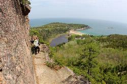
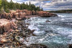
South Bubble
Bar Harbor, Maine
4.0 miles SW of Bar Harbor, MaineA lesser known climbing spot in Acadia National Park. Most people will head out to Otter Cliff or the Precepice, but South Bubble will stay relatively uncrowded. The majority of the climbing areas are Trad climbing, with the Lower slab and Upper slab offering two different climbing experiences.
Lower slab is mainly for friction and face climbing. The Upper slab includes some good climbs from 5.4 to 5.8 and is mainly moderate routes on a more vertical terrain. All of the Upper slab climbs are accessed by climbing up the Lower slab, where there is a nice ledge to start climbs from. Some of the climbs that finish at the top of the Upper slab give great views of the area and also have beautiful sunsets depending on the time of year.
When reaching the top of the Upper slab, climbers can just scramble up to the summit and follow the hikers trail back down. Climbers should be careful of hikers, they may end up kicking rock down towards climbers on South Bubble. During climbing season there are several climbing guide schools that may come out to climb at South Bubble because it is a great beginners area.
The Precipice
Bar Harbor, Maine
2.8 miles S of Bar Harbor, MaineThe Precipice is another popular climbing spot in Acadia National Park. Unlike Otter Cliffs, this spot is on the south side of Champlain Mountain and includes a 200 ft crag as well as other excellent climbing routes. Most of the routes range in difficulty from a 5.6 to 5.12a/b. The top of the climbs give climbers a spectacular view of the Atlantic Ocean. Most of the climbs do not have many permanent bolts and so additional precautions must be taken, climbers are usually good if they bring along different cams to aid in the climb.
Overall this climbing spot has many routes aimed at the more experienced climber. Some of the routes have multiple pitches, thin cracks, and good corners to work with. Many there are several climbing companies found locally that take people out to this area to climb, so get in early to make sure that the desired routes to climb are still available.
Otter Cliff
Bar Harbor, Maine
5.4 miles S of Bar Harbor, MaineOtter Cliff is the most popular spot to go rock climbing in Acadia National Park. There are several dozen different routes with varying levels of difficulty which climbers can choose from. Be aware, guided climbing companies take over many of the popular routes during peak season, so head out early to get a good spot. The anchors for the different climbs are all steel bars pounded into the cliff face.
What makes this area so unique is that it offers great sea cliff climbing which is difficult to find in most places. Most of the routes have to be top ropped or rappelled down to. Be careful of high tide as this time usually covers many of the route starting places will end up underwater. The routes at Otter Cliff are about 60 ft sea cliffs, in which most people will do crack and face climbing. With a variety of routes available, the most difficult routes are about a 5.12.
2.0 mi
 Full Listing
Show more
Hike
Added on 3 Jul 2017
Full Listing
Show more
Hike
Added on 3 Jul 2017
Ocean Path
Bar Harbor, Maine
4.1 miles S of Bar Harbor, MaineOcean Path is a great trail in the Sand Beach area that takes visitors on a leisurely hike along the ocean. This hike takes visitors to Otter Cliff, the most popular rock climbing spot in Acadia, as well as to the Thunder Hole. Trail access is found at the Sand Beach parking lot and the first part is a steep climb. However after this point the trail levels out and meanders along the surrounding cliffs. Most visitors will enjoy the beautiful views of the Gulf of Maine.
One of the treasures of this trail is the Thunder Hole. The Thunder Hole is a sea cliff where the acutal cliff has a low cavern away from view. When the conditions are just right, the tide will come in and close off the air to the cavern creating a loud thunder sound similar to a distant rumble during thudnerstorms.
At the end of the Ocean Path trail there is a great spot that will have tide pools when thte tide is low. Sometimes visitors will be able to see little creatures such as crabs, dog whelks, and sea anemones.
Beehive Trail
Bar Harbor, Maine
4.1 miles S of Bar Harbor, MaineBeehive trail is considered to be the most difficult trail in the Sand Beach area. Because the trail is so popular it is well maintained and taken care of. What makes this hike difficult for some is the steep climb in the beginning. There have been iron railings put along the path to aid in the hike upwards. Also this trail is right along the ocean and has several steep drop offs, so those who have a fear of heights may not want to attempt this hike.
Access to the trail can be found from the Sand Beach parking lot. Overall the trail includes many beautiful views of the Sand Beach area as well as the Gulf of Maine.
Niagara Falls
Beaver, Oregon
10.6 miles SE of Beaver, OregonNot to be mistaken with the famous waterfall in Canada, this waterfall is rarely visited but very beautiful! Two waterfalls tumble down trying to out do the other, and it makes for a wonderous sight. The two waterfalls that are visible are Pheasant Creek Falls and Niagara Falls, though the Pheasant Creek falls are often considered the better of the two to view. The Niagara waterfall is 107 ft tall, and is formed from several unnamed creeks in the area that come from the Niagara Point.
This trail can be hiked anytime of the year, however the best time to see it is in the winter and spring when the water is really flowing down the creeks. The trail is a little over one and a half miles long and is a pretty easy hike. Visitors can go down right by the waterfall and enjoy a little shower from the falls. Pheasant Creek Falls goes into a small pond making a nice plunge over a narrow band of land.
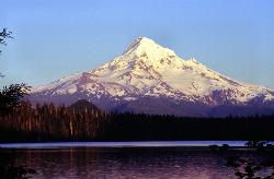
Lost Lake Loop Trail
Cascade Locks, Oregon
12.5 miles S of Cascade Locks, OregonA beautiful lake with an incredible view! Right along the lakeshore of Lost Lake, Mount Hood towers in the distance.
Glen Aulin
Glen Aulin, California
0.3 miles SE of Glen Aulin, CaliforniaThis trail is a popular route to take in the Yosemite High Country because it is a good introductory hike into the backcountry. At the end of the hike there are several waterfalls as well as a High Sierra Camp to stay at. This can be done as a day hike to the High Sierra Camp, and visitors can then enjoy a good meal and a nice tent. If hikers do not wish to pay the fee for the meal service/provided tent, there are several backpacker campsites throughout the site as well.
The majority of the trail will follow the Tuolumne River as it meanders through the Tuolumne Meadows and up into the High Sierra. Once reachingn the Glen Aulin camp, the beautiful White Cascade waterfall will be right next to the camp. Most visitors will use this camp as a basecamp for their adventures because the area has so many cool places to explore. One area that is popular to go to is Waterwheel Falls, which passes through a unique granite canyon. Outside of the camp and part of a different day hike is a trip to the Grand Canyon of the Tuolumne. Many people will also enjoy a quick swim in the river, depending on how swift the current is.
There is plenty of wildlife to see, especially when the trails first open. Usually the trail will be open once road access is cleared to Tuolumne Meadows. Because of elevation, the flowers will bloom later than flowers found in Yosemite Valley. Also due to elevation, the High Country will be much cooler during the summer than in most places in the park.
Jade Lake
Skykomish, Washington
7.7 miles E of Skykomish, WashingtonJade Lake is a beautiful treasure of a lake located in the Snoqualmie region of Washington. This trail is about 26 miles and is usually done as an over night backpacking trip. This hike will take backpackers past some beautiful lakes as well as provide excellent views of the nearby moutains.
The trail to Jade Lake has several starting points, some will have parking lots available, but they fill up rather quickly on weekends. Following the Deception Creek trail, hikers will go for about 5 miles until they reach Deception Pass. Here the trail becomes a junction for several other trails in the area, but hikers will want to take the trail for Marmot Lake. At first, this part of the trail will be about a 2 mile descent through wildflower meadows (depending on the season) followed by a 2 mile climb back up, eventually reaching Marmot Lake. Some people choose to camp here for the first night and catch their breath at this beautiful lake. This lake is great for swimming and provides a refreshing soak after a long hike.
After resting at Marmot Lake, continue on the east side of the lake where a trail will take hikers up a steep scramble of talus. This eventually opens up into an alpine meadow, and be sure to look for local wildlife while hiking around. The next lake hikers will see is No-Name-Lake, and from here it is only a short distance to Jade Lake. At Jade Lake, there are several other activities to do including swimming or fishing in the lake. In the mountains surrounding Jade Lake is a glacier that can be hiked to. If hiking to the glacier, it might be best to have some crampons and an ice axe. This makes the hike much easier, though isn't required. Views at Jade Lake include Mount Daniel, which is the highest point in Kings Canyon. Most people will take a day pack with them so they don't have to carry around their heavy backpack while exploring the area.
For the return trip, just take the trail back to the parking lot. This can also be split into multiple days if wanting to take it slower, or it can be done in one day.
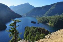
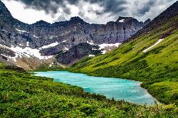
Diablo Lake
Rockport, Washington
27.2 miles NE of Rockport, WashingtonDiablo Lake is one of the most jaw-droppingly beautiful places in Washington — a reservoir of surreal turquoise water cradled by the jagged peaks of North Cascades National Park. That unreal blue-green color isn't a filter: it comes from glacial flour, the finely ground rock that surrounding glaciers grind up and wash into the lake, where it hangs suspended and scatters sunlight into vivid jade. Framed by Colonial, Pyramid, and Davis Peaks and the flanks of Sourdough Mountain, it's a scene that stops travelers in their tracks along the North Cascades Highway.
The lake is part of a chain of hydroelectric reservoirs (behind Diablo Dam, with Ross Lake and Ross Dam just upstream), built and run by Seattle City Light, yet the setting feels wonderfully wild. There's plenty to do: kayaking, canoeing, and paddleboarding on the glassy water are the signature experiences, and the lake is popular for fishing and boating, with a boat launch at the Colonial Creek area. On land, hiking trails like Thunder Knob and the Diablo Lake Trail lead to sweeping overlooks, and the famous Diablo Lake Overlook on Highway 20 delivers the classic postcard view without any hiking at all.
A serious word about swimming. Yes, you can swim — but this is glacier-fed water, and it is dangerously cold, seldom rising above about 50°F even in summer. Cold water like this can incapacitate a swimmer shockingly fast, and accidental immersion can be fatal within minutes. If you do get in, stay close to shore, keep it brief, never swim alone, and take the cold seriously — it's far more hazardous than the calm, inviting surface suggests. Life jackets are essential for any paddling.
Getting there and timing take some planning. Diablo Lake sits along the North Cascades Highway (SR 20) east of Marblemount; the highway's high stretch closes every winter for snow and avalanche danger, so the prime season is roughly late spring through early fall. Road conditions can change — sections of SR 20 have been affected by damage — so check current status before you go, though the lake and the Colonial Creek Campground area typically remain accessible from the west.
There's more to explore nearby. Diablo Lake sits within the Ross Lake National Recreation Area, and the little Seattle City Light company town of Newhalem just downstream offers a visitor center, the illuminated Ladder Creek Falls garden, and interpretive walks. Upstream, Ross Lake stretches for miles into the wilderness toward the Canadian border, making the whole Skagit River corridor a rewarding multi-day destination.
Come prepared for a mountain-park visit: bring layers for changeable weather, sun protection, and plenty of water, and stop at the North Cascades Visitor Center or the Diablo Lake Overlook for orientation. Camp at Colonial Creek for lakeside nights, paddle the turquoise water by day, and pack out everything to keep this glacial gem pristine. Few places in the country pair color and grandeur quite like Diablo Lake.
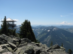
Granite Mountain
North Bend, Washington
15.4 miles SE of North Bend, WashingtonThis hike up Granite Mountain comes with a steep price, so be prepared for a good climb to the top. Elevation gain is about 1,000 ft per mile, and should be done by those who are in good shape to handle the strain. Part of the reason people love going on this hike is the beautiful views available from the lookout point at the summit. Hikers will be able to see Mount Rainier in the distance as well as Mount Stewart and the Teanaway.
The trail begins off the highway at the Pratt Lake trailhead. Hikers will follow this trail for about 1.2 miles until they reach a trail junction. Pratt Lake continues on the left, while Granite Mountain takes off on the right. There are switchbacks along the trail, with one of the early switchbacks giving an excellent view of steep, debris filled avalanche chute. This hike is especially dangerous in the winter and early spring, and it is highly adviced that hikers wait until the snow melts before attempting this hike as the avalanche risk is very high.
Once past the trail junction, the Granite Mountain trail becomes narrower and rockier as hikers begin their way towards the summit. The trail is shaded, however because of the steep climb, most hikers will not feel cold but pretty warm. Switchbacks meander across the mountain, and about a mile after the junction, hikers will be at the top of the previously seen avalanche chute. There is a seasonal stream which can be used to refill water, just remember to filter. Continuing up along the trail, there will be some flatter spots through a few meadows and forests before reaching a talus slope. At this point the outlook will be in view, but there is still a difficult climb to the top.
Overall this trail is gruelling and steep, however the views are well worth the work it takes to get to the top. There is a ranger outlook which is sometimes open to the public at the top, and makes for a great rest spot. This trail tends to get crowded on the weekends, so it might be best to go during the week.
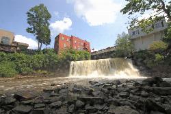
Chagrin Falls
Chagrin Falls, Ohio
0.2 miles N of Chagrin Falls, OhioChagrin Falls is a charming, all-natural waterfall tumbling right through the heart of the storybook village of Chagrin Falls, Ohio, just southeast of Cleveland. So central is the cascade that the entire town grew up around it — today it's a beloved community landmark, with the Chagrin River spilling over a scenic tiered falls steps from Main Street's shops and cafes.
The falls are a series of drops on the Chagrin River, prettiest after rain or spring snowmelt and lovely in every season. Best of all, they're completely free to enjoy. From the Falls Viewing Area just off the Main Street bridge, staircases lead down to an up-close seating area beside the lower falls, and the refurbished Main Street Bridge offers sweeping sightlines of both the upper and lower cascades.
Right alongside is Riverside Park, the village's iconic green space — open lawns, shade trees, a brick riverside walking path, picnic tables, a playground, and ducks to feed — a perfect spot to spread out a picnic, let the kids play, and take in the falls. This is a scenic viewing-and-strolling destination rather than a swimming hole; enjoy the water from the overlooks and paths and stay safely back from the slippery rocks and current at the brink.
It's an easy, family-friendly outing year-round, and the walkable village around it — full of boutiques, restaurants, and an old-fashioned popcorn shop — makes for a delightful day trip. Pair your visit with a stroll through town and a picnic in Riverside Park, and enjoy one of Ohio's most photogenic small-town waterfalls.
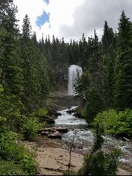
Ladder Creek Falls
Marblemount, Washington
13.9 miles NE of Marblemount, WashingtonLadder Creek Falls is found behind the Gorge Powerhouse in Newhalem. This short trail takes visitors to the top of the the beautiful three tiered waterfall that is fed by Ladder Creek. Since the 1930's this trail has been a popular attraction because of the beauty of the waterfall and the excellent plant life surrounding the area. At night the waterfall is illuminated by a light show, making it a unique experience. The waterfall can be visited anytime of day year-round. Along with taking a brief hike to the waterfall, there is a garden that visitors can meander through as well.
Siyeh Pass Trail
Logan Pass, Glacier National Park
2.3 miles E of Logan Pass, Glacier National ParkThe Siyeh Pass Trail is widely considered one of the finest day hikes in Glacier National Park — a roughly 10-mile point-to-point traverse that climbs through flower-filled meadows to a high alpine pass with top-of-the-world views, then descends a dramatic canyon toward Saint Mary Lake. With about 2,250 feet of elevation gain to a high point near 8,080 feet, it's a strenuous but hugely rewarding outing that samples the very best of Glacier: wildflowers, glaciers, wildlife, and staggering mountain scenery.
The classic route begins at Siyeh Bend on the Going-to-the-Sun Road and ends at Sunrift Gorge, so it's a one-way hike — you'll ride the park shuttle back to your car (more on that below). From the trailhead the path climbs about 2.5 miles through forest before opening up; where the trail splits, keep toward Preston Park, one of the most beautiful subalpine meadows in the park and a perfect spot to rest beneath 10,000-foot Mount Siyeh. From the meadow, a series of switchbacks climbs the flank of Matahpi Peak to the pass itself — the high point of the hike, with sweeping views over several drainages at once.
The descent is every bit as spectacular. Dropping toward Baring Creek, hikers pass close to Sexton Glacier, wander through wildflower slopes, and often spot mountain goats and bighorn sheep on the rocky heights. Depending on the season you may cross lingering snowfields. The trail finally winds down to Sunrift Gorge on the shore of Saint Mary Lake, where you catch the shuttle back to Siyeh Bend.
Plan around the logistics. The hike sits along the Going-to-the-Sun Road, and reaching the trailheads is easiest via the park's free shuttle — but in 2026 the shuttle requires a reservation (a small processing fee, released 60 days ahead or at 7 p.m. the night before). A park entrance pass is required. The high country stays snowbound much of the year, so the season generally runs from about mid-July into late September; check current trail and road status before you go.
Keep an eye on the rock underfoot, too. The colorful red and green cliffs here belong to the ancient Belt Supergroup, and the trail passes limestone of the Helena (Siyeh) Formation that holds stromatolites — fossilized mats of blue-green algae roughly 1.45 billion years old, among the oldest visible signs of life on Earth. It's a humbling thing to spot mid-hike: proof that this dramatic landscape has a story reaching back almost unimaginably far.
This is grizzly country, and bear sightings are common, so carry bear spray, know how to use it, and make noise on blind corners. Bring layers for fast-changing alpine weather, sun protection, plenty of water, and sturdy footwear for the long descent. Start early to secure parking and your shuttle, and give yourself the whole day — Siyeh Pass rewards every mile with the kind of scenery that makes Glacier famous.
11.8 mi
 Full Listing
Show more
Backpack, Camp, Hike
Added on 19 Jun 2017
Full Listing
Show more
Backpack, Camp, Hike
Added on 19 Jun 2017
Cracker Lake Trail
Many Glacier, Glacier National Park
0.1 miles SE of Many Glacier, Glacier National ParkWhat impresses people most about this lake is the surreal turquoise color of the lake. Regardless of the beautiful mountain cliffs and forests found along the trail, Cracker lake is definitely a must see. Located in the Many Glacier area of Glacier National Park, the trail is about 12.5 miles one way, though it is a good hike to break up into a two day trip if using the backpacking campgrounds. The beginning of the hike has a lot of horse traffic, which makes the trail either really muddy or very dusty (depending on the time of year). For most of the beginning, the trail meanders through thick forests and along some streams.
The trail starts out at Many Glacier Hotel parking lot. From here the trail follows Allen creek, eventually taking hikers through thick forest. This trail goes through active bear country, so please take precautions. Going through thick forests and around blind turns makes it easier to run into a bear if not careful. Carry bear spray and be alert. While going through the forest, a waterfall will come into view which is falling from one of the surrounding mountains. There is no trail to reach the waterfall, but it is breathtaking to see. The forest will finally break off when hikers reach the basin where Cracker lake is located. The trail continues for another mile and a half to the lake overlook. The mountains that can be seen on the trail and from the lake are Mt Siyeh and Allen Mountain.
There are three campsites available on the edge of Cracker lake. Those who decided to camp here will be able to camp beneath one of the largest rock faces on the continent. One drawback to the campsites is that there is no tree coverage, but everything is out in the open. The weather definitely will play into how comfortable of a night it would be at the campsites. The surrounding mountains have very interesting and beautiful sediment layers and were carved from glaciers thousands of years before. There is also an old copper mine and some old mining equipment near the lake. Hikers are prohibited from entering into the mine.
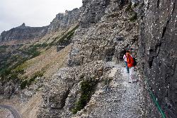
Highline Trail
Logan Pass, Glacier National Park
0.1 miles SE of Logan Pass, Glacier National ParkOne of the most popular hikes in Glacier National Park. The Highline Trail is on many people's hiking lists because it showcases all of the beauty of Glacier National Park in just one hike. This hike takes hikers up through Alpine meadows, the top of the Continental Divide, and past several lakes.
The trail is found at the Logan Pass Visitors Center. From here, hikers will cross the road and begin along the Highline Trail. As hikers make their way along the trail and up to the Continental Divide, they will face some significant elevation gain. The trail is split into two parts, the southern half and the northern half. The southern half is about 7 miles one way and finishes at Granite Park Chalet, with the northern half picking up from Granite Park Chalet and continuing to Waterton Valley/Flattop Mountain Trail Junction.
From the beginning, the trail goes through a meadow and then begins to climb along the Garden Wall Divide. There is some exposure along this part of the trail, though the trail is pretty wide. During the summer a cable is put up along the Garden Wall for extra support while hiking, however this part of the trail does not last very long. After hiking along the cliff face, the trail goes through several grassy meadows with streams flowing, making a good place to refill on water. The next stop is a rock field which then leads to switchbacks on the east side of Haystack Butte. When hiking over Haystack Butte, there will be a trail for Grinnell Glacier Overlook. This is a good detour hike for those who are fit enough for some extra miles, and offers excellent views of Many Glacier and Upper Grinnell Lake.
After the butte, the trail makes a slight decline to Granite Park Chalet. This chalet sells water and food for hikers, includes bathrooms and rooms to sleep in. If hikers wish to continue from Granite Park Chalet on the northern half of the trail, they will continue from here for about 11 miles. Depending on how late in the season hikers go, the northern half of the trail may still have significant snow in places. However, the trail is still beautiful and often less crowded than the southern half. The northern half takes hikers toward Ahern Pass and Sue Lake. Towards the end of the trail there is a campground where people can choose to spend the night and then return back to Logan Pass the next day.
This hike has plenty of wildlife and nature to see. It isn't uncommon to see Mountain Goats as well as deer and bighorn sheep. Be aware, this is bear country and it is advised to carry bear spray when hiking.
Cameron Lake
Waterton, Glacier National Park
7.8 miles SW of Waterton, Glacier National ParkCameron Lake is found in the Canadian portion of Glacier National Park, usually referred to as Waterton Lakes National Park. The lake is a picturesque spot to rest and relax while enjoying the beautiful glacial mountains and the stunning landscape. For those who go to visit the lake, there is plenty to keep busy or to relax. Many visitors enjoy getting out onto the water on a clear day and kayaking/canoeing on the water surface. There are fish in the lake, making it a great place to enjoy a little fishing as well when the weather is nice.
Hikes in the area will travel around the shoreline of Cameron Lake, as well as up to Mt Custer. Mt Cluster is located in Glacier National Park and helps to make up the southern shore of Cameron Lake. A prominent feature on the mountain is Herbst Glacier, which helps to create waterfalls during the summer season, and makes a beautiful scene right along the lake. The shoreline is covered in trees, though some sports show the aftermath of avalanches while others are covered in bushes and other shrubbery. There has been sightings of bears, so be careful and alert when exploring the area.
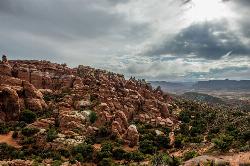
Fiery Furnace
Moab, Utah
11.8 miles N of Moab, UtahA fun place to go hiking within Arches National Park. The Fiery Furnace area is a permit only area, with several ranger-led tours available. Hiking permits are required in order to enter, as well as a good knowledge of the area or a guide with experience of the area.
This area is a labyrinth among towering sand stone formations and it is easy to get lost if not guided by someone with a knowledge of the area. There is one counter-clockwise route through the Fiery Furnace, but there are multiple paths that visitors can take to make it a unique and enjoyable journey. Ranger guided trips are held twice a day during the summer months.
What makes this trail so enjoyable are the many different sights to see in the Fiery Furnace. Throughout the trail visitors will see arches that they will need to hike under, as well as delicate wildlife. This trail is not just a hiking trail, but visitors will be climbing, squeezing, and crawling their way through many of the fantastic rock formations in the furnace. Some of the formations visitors will see are "Surprise Arch" and "Crawl Through Arch".
There is a fee for takign a ranger-led tour, and a hiking permit must be obtained before going into the Fiery Furnace.
×


