


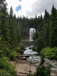
St Mary and Virginia Falls
Rising Sun, Glacier National Park
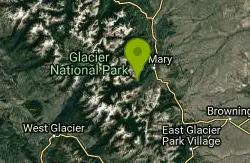
| Address: | Going-to-the-Sun Rd, Browning, MT 59417, USA |
| GPS: |
48°40'28.0"N 113°36'30.4"W Maps | Directions |
| State: | Montana |
| Trails/Routes: | 1.4-4.6 mi |
Rivers Waterfalls Trails Wildflowers National Park Restrooms Picnic Tables Bicycles Motorized Use
Hike
Virginia Falls is one of two major waterfalls that feed into St Mary Lake. The trail is about 3.7 miles roundtrip, where visitors will see other waterfalls such as St Mary waterfall. The trail begins at the St Mary Falls trailhead on Going-to-the-Sun road, where there is a parking lot. Becasue there are multiple waterfalls in the area, this parking lot can get full very quickly, so it might be best to head out early in the morning or take a shuttle from Many Glacier.
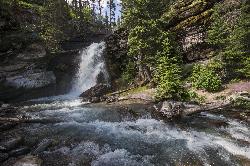
An easy and scenic trail, visitors will go through the forest and past streams. St Mary Falls is a two tiered waterfall with a drop of over 50 ft. If tired, there are some nice spots to sit and catch a break, as well this point can make a good turn around point.
Virginia Falls is the next waterfall hikers will see. There is an upper portion of the falls and a lower portion. Both are beautiful to see. Like most waterfalls, the best time to see them is early in the season when the snowmelt is beginning and water is tumbling over the falls.
Mapped Route/Trail Distances
| St Mary Falls Trailhead to St Mary Falls (one-way) | 1.6 miles Round Trip |
| St Mary Falls Parking Lot to St Mary Falls (one-way) | 2.2 miles Round Trip |
| Siyeh Pass Trailhead to St Mary Falls (one-way) | 3.9 miles Round Trip |
| Sun Point Nature Trail to St Mary Falls (one-way) | 4.6 miles Round Trip |
| St Mary Falls to Virginia Falls (one-way) | 1.4 miles Round Trip |
More Information
Be courteous, informed, and prepared. Read trailhead guidelines, stay on the trail, and don't feed the wildlife.
Read More- Plan Ahead and Prepare
- Travel & camp on durable surfaces
- Dispose of waste properly
- Leave what you find
- Minimize campfire impacts
- Respect wildlife
- Be considerate of other visitors
Directions
From Rising Sun, Glacier National Park
- Head southwest toward Rising Sun Roadi (0.2 mi)
- Turn right onto Glacier Rte 1 Rd/Going-to-the-Sun RdParts of this road may be closed at certain times or daysDestination will be on the left(5.1 mi)
endovereric
7/2/18 1:44 pm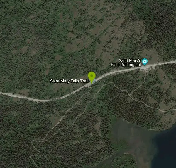 Virginia Falls from Continental Divide Trail courtesy of endovereric↗

 Virginia Falls from near St Mary Trailhead courtesy of endovereric↗
 Trail to St Mary Falls through burnt woods courtesy of endovereric↗
 St Mary Falls courtesy of endovereric↗
 View of the river beyond St Mary Falls courtesy of katiemia↗
 Lower Waterfall courtesy of endovereric↗
 Trail to Virginia Falls courtesy of endovereric↗
 Other Lower Waterfall courtesy of endovereric↗
 Virginia Falls courtesy of endovereric↗
 St Mary Map courtesy of npmaps.com↗

Added by cteicheira
Trails
Distance ?
1.6 miles Round TripElevation Gain ?
-216 feetReal Ascent ?
61 feetReal Descent ?
277 feetAvg Grade (-3°)
-5%Grade (-12° to 5°)
-22% to 9%Distance ?
2.2 miles Round TripElevation Gain ?
-230 feetReal Ascent ?
140 feetReal Descent ?
370 feetAvg Grade (-2°)
-4%Grade (-13° to 12°)
-23% to 20%Distance ?
3.9 miles Round TripElevation Gain ?
-151 feetReal Ascent ?
365 feetReal Descent ?
516 feetAvg Grade (-1°)
-1%Grade (-17° to 21°)
-30% to 38%Distance ?
4.6 miles Round TripElevation Gain ?
-65 feetReal Ascent ?
429 feetReal Descent ?
494 feetAvg Grade (0°)
-1%Grade (-12° to 21°)
-22% to 38%Distance ?
1.4 miles Round TripElevation Gain ?
328 feetReal Ascent ?
338 feetReal Descent ?
10 feetAvg Grade (5°)
9%Grade (-3° to 15°)
-5% to 26%Elevation differences are scaled for emphasis. While the numbers are accurate, the cut-away shown here is not to scale.
Other Hiking Trails Nearby
Baring Falls
Glacier National Park
0.6 miles NEThe Baring Falls are named after the Baring Creek, which flows into the Middle Fork of the Flathead River. The falls themselves are a stunning sight to behold, with a 30-foot drop into a pool of...
Hike
Siyeh Pass Trail
Logan Pass, Glacier National Park
3.3 miles NWLIke many of the trails found throughout Glacier National Park, Siyeh Pass trail takes hikers through beautiful meadows and forests, complete with top-of-the-world views. The trail begins at Siyeh...
Backpack, Hike
Clements Mountain Trail
Logan Pass, Glacier National Park
5.2 miles WLocated in Glacier National Park, Clements Mountain is a four mile round trip hike. Clements Mountain is often mistaken for Reynolds Mountain, both of which can be seen from the Logan Pass...
Backpack, Camp, Hike, Rock Climb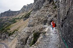
Highline Trail
Logan Pass, Glacier National Park
5.2 miles WOne of the most popular hikes in Glacier National Park. The Highline Trail is on many people's hiking lists because it showcases all of the beauty of Glacier National Park in just one hike. This...
Backpack, Hike 5.0 mi
Hidden Lake
Glacier National Park
5.2 miles WThe Hidden Lake Trail in Glacier National Park is a moderate to strenuous hike that offers breathtaking views of the surrounding landscape. Located in the northwest region of Montana, the park is...
Hike
Grinnell Lake
Many Glacier, Glacier National Park
7.5 miles NWGrinnelll Lake was named after George Bird Grinnell who helped make Glacier into a national park. This lake allows visitors to see one of the remaining glaciers in the park and take in the immense...
Hike, Swim 11.8 mi
Cracker Lake Trail
Many Glacier, Glacier National Park
8.6 miles NWhat impresses people most about this lake is the surreal turquoise color of the lake. Regardless of the beautiful mountain cliffs and forests found along the trail, Cracker lake is definitely a must...
Backpack, Camp, Hike 9.7 mi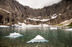
Iceberg Lake
Many Glacier, Glacier National Park
9.2 miles NA pleasant trip into Glacier National Park, coming out to be about 9 miles round trip. The lake sits at the basin of mountains carved by glaciers thousands of years ago. Along the way, hikers will...
Backpack, Camp, Hike 10.5 mi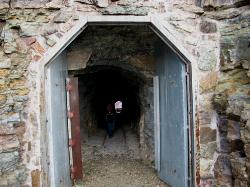
Ptarmigan Tunnel
Many Glacier, Glacier National Park
9.2 miles NThis trail takes vistors to one of the manmade features in Glacier National Park. The trailhead can be found by taking the Iceberg Lake trailhead, and following it until the trail junction past...
Backpack, Hike 4.5 mi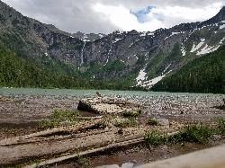
Avalanche Lake
Apgar Village, Glacier National Park
9.6 miles WHike near Apgar Village, Glacier National Park
Hike 0.9 mi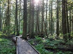
Trail of the Cedars
Apgar Village, Glacier National Park
9.6 miles WThe Trail of the Cedars is one of the most popular hikes in the park because of it offers great views without too much exertion. It is a short loop hike around Avalanche Creek in Glacier...
Hike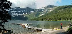
Cameron Lake
Waterton, Glacier National Park
30.9 miles NWCameron Lake is found in the Canadian portion of Glacier National Park, usually referred to as Waterton Lakes National Park. The lake is a picturesque spot to rest and relax while enjoying the...
Backpack, Camp, Hike
Jewel Basin
Kalispell, Montana
37.8 miles SWBeautiful hiking area in the Montana wilderness, Jewel Basin is home to lakes with plenty of fish, and many peaks to ascend.
Backpack, Camp, Hike
Harry Harm Park
Bigfork, Montana
48.0 miles SWHike near Bigfork, Montana
HikeNearby Campsites
Rising Sun Campground
Glacier National Park
4.2 miles ELocated in the eastern part of the park, the Rising Sun Campground offers breathtaking views of the surrounding mountains and forests. The campground has over 150 sites, all of which are equipped...
Camp
Clements Mountain Trail
Logan Pass, Glacier National Park
5.2 miles WLocated in Glacier National Park, Clements Mountain is a four mile round trip hike. Clements Mountain is often mistaken for Reynolds Mountain, both of which can be seen from the Logan Pass...
Backpack, Camp, Hike, Rock Climb 11.8 mi
Cracker Lake Trail
Many Glacier, Glacier National Park
8.6 miles NWhat impresses people most about this lake is the surreal turquoise color of the lake. Regardless of the beautiful mountain cliffs and forests found along the trail, Cracker lake is definitely a must...
Backpack, Camp, Hike
Many Glacier Campground
Many Glacier, Glacier National Park
9.0 miles NCamp near Many Glacier, Glacier National Park
Camp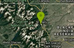
St. Mary Campground
Glacier National Park
9.1 miles NESt. Mary Campground is a popular campsite located in the beautiful Glacier National Park in Montana. Nestled in the heart of the park, St. Mary Campground offers breathtaking views of the surrounding...
Camp 9.7 mi
Iceberg Lake
Many Glacier, Glacier National Park
9.2 miles NA pleasant trip into Glacier National Park, coming out to be about 9 miles round trip. The lake sits at the basin of mountains carved by glaciers thousands of years ago. Along the way, hikers will...
Backpack, Camp, Hike
Avalanche Campground
Glacier National Park
9.6 miles WAvalanche Campground is a popular destination for visitors to Glacier National Park in Montana. Located on the western side of the park, the campground is just a short drive from the Apgar Visitor...
Camp
Cut Bank Campground
Glacier National Park
11.5 miles SENestled in a beautiful forested setting along the Cut Bank Creek, Cut Bank Campground offers a peaceful and serene atmosphere for campers to enjoy. The campground has a total of 48 campsites, all...
Camp
Sprague Campground
Glacier National Park
13.5 miles WSprague Campground is a popular destination for travelers visiting Glacier National Park in Montana. Located on the west side of the park, the campground is named after Amos Sprague, one of the first...
Camp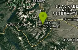
Two Medicine Campground
Glacier National Park
16.9 miles SECamp near Glacier National Park
Camp
Fish Creek Campground
Glacier National Park
19.3 miles SWFish Creek Campground is a popular campsite located within Glacier National Park in Montana. It offers a peaceful and picturesque setting for travelers looking to experience the beauty of the...
Camp
Apgar Campground
Apgar Village, Glacier National Park
20.0 miles SWApgar Campground is a beautiful campsite located in the heart of Glacier National Park in Montana. Situated on the shores of Lake McDonald, this campground offers stunning views of the surrounding...
Camp
Logging Creek Campground
Glacier National Park
26.7 miles WLogging Creek Campground is a popular camping destination located in the beautiful Glacier National Park in Montana. With its stunning mountain views and close proximity to a variety of outdoor...
Camp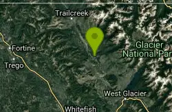
Quartz Creek Campground
Glacier National Park
28.3 miles WQuartz Creek Campground is a popular destination for campers visiting Glacier National Park in Montana. Located in the heart of the park, this campground offers a peaceful and serene setting for...
Camp
Bowman Lake Campground
Glacier National Park
29.1 miles WLocated in the heart of Montana's Glacier National Park, Bowman Lake Campground offers visitors the chance to experience the stunning beauty of the park's rugged landscape. With its crystal...
Camp
Cameron Lake
Waterton, Glacier National Park
30.9 miles NWCameron Lake is found in the Canadian portion of Glacier National Park, usually referred to as Waterton Lakes National Park. The lake is a picturesque spot to rest and relax while enjoying the...
Backpack, Camp, Hike
Kintla Campground
Glacier National Park
32.6 miles NWKintla Campground is a beautiful and peaceful campsite located in the heart of Glacier National Park in Montana. The campground is situated along the shores of Kintla Lake, which offers stunning...
Camp
Jewel Basin
Kalispell, Montana
37.8 miles SWBeautiful hiking area in the Montana wilderness, Jewel Basin is home to lakes with plenty of fish, and many peaks to ascend.
Backpack, Camp, Hike


