


Refine Search
- hike 74
- mountain bike 31
- camp 30
- swim 24
- backpack 14
- canoe 12
- sled 12
- cave 12
- cross-country ski 10
- kayak 9
- rock climb 8
- dive 7
- horseback 7
- disc golf 7
- airsoft 6
- paintball 5
- skateboard 2
- snowshoe 2
- hot springs 2
83 locations
Add Location
 Full Listing
Camp, Canoe, Dive, Kayak, Swim
Last visited on 7 Apr 2018
Full Listing
Camp, Canoe, Dive, Kayak, Swim
Last visited on 7 Apr 2018
 Full Listing
Camp, Canoe, Dive, Kayak, Sled, Swim
Last visited on 6 Jul 2017
Full Listing
Camp, Canoe, Dive, Kayak, Sled, Swim
Last visited on 6 Jul 2017

 Full Listing
Skateboard
Last visited on 4 Apr 2017
Full Listing
Skateboard
Last visited on 4 Apr 2017
 Full Listing
Hike
Last visited on 1 Apr 2017
Full Listing
Hike
Last visited on 1 Apr 2017
1.1 mi
Full Listing
Hike, Mountain Bike
Last visited on 16 May 2018

Hidden Vista / Pine Loop
Ririe, Idaho
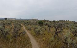
9.0 miles E of Ririe, IdahoYou'll find the Hidden Vista trailhead on the South End of the Buckskin Morgan parking lot about a mile past Y Junction. This is a short trail with a little up and a little down for just under a 1/2 mile to the Hidden Vista where the trail opens up to the canyon and all the way out to the Snake River. The view isn't what you'd have at the top of a peak but is nonetheless and beautiful view. From there, you can go back the way you came or take a detour off to the right (East) on your way back and get a little downhill action. There's pretty good little climbs, turns, rocks, and even some fun jumps at the bottom. When you're done playing on the jumps, it's just a short climb back up to the parking lot or to the trailhead so you can do it again. The trail is primary singletrack, is fairly well maintained, and is shared by hikers and mountain bikers.
0.6-5.5 mi
 Full Listing
Mountain Bike
Last visited on 26 Apr 2018
Full Listing
Mountain Bike
Last visited on 26 Apr 2018
Old Ranger
Ririe, Idaho
15.2 miles E of Ririe, IdahoOn the South end of the Big Hole mountains just above the Snake River is a grueling yet diverse section of single-track on Forest Service Trail 287 called Old Ranger. Because of the southern exposure and relatively low elevation, the Old Ranger mountain bike trail is a great ride for early in the season or just as winter is setting in when many of the other trails are getting snow or are still covered in snow, ice, and mud.
Old Ranger is not easy. Much of it is pretty moderate with plenty of flowy sections but there's also a lot of pretty chunky spots and plenty of tough climbs where you'll be hiking quite a bit. Even if you're in amazing shape, there are two very steep climbs going West or one insanely steep climb going East that you'll be pushing or carrying that bike. You can start from the West and and make this a bigger longer finish to your Wolverine Creek trail, ending up at Burns Creek. The preferred direction is actually uphill overall, starting at Burns Creek and ending at Wolverine Creek (FS Trail 082) for a great finish down to the river.
2.3 mi
 Full Listing
Hike
Last visited on 10 Apr 2018
Full Listing
Hike
Last visited on 10 Apr 2018
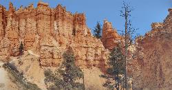
Queens Garden Trail
Bryce, Utah
3.2 miles S of Bryce, UtahThe Queen's Garden Trail is the hike to see the wonders of Bryce Canyon's main amphitheater from all angles. Starting at Sunrise Point, you'll have a great view from the rim before the trail wraps it's way down through the hoodoos. The dirt trail is very well kept and wide with a little bit of a flowy feel. There are benches and logs along the way if you need a breather but beyond the trails edge is a steep descent, often on both sides. As you follow the trail deeper, that exposure becomes less severe but even at the top, it's only scary if you think your kids might plunge over the side. The trail offers plenty of room to stay well away from the edge.
As you descend, you'll see new details of the rocks and hoodoos as you get ever closer and begin to look up at them a little more. The trail goes right through the wall in a couple of places as well with great little tunnels cut out of the rock. Make sure to take what looks like a detour into the Queen's Garden. There's a placard there that explains the location and will help you find the Queen Victoria rock structure a little easier. It's also where you'll notice the change in ecosystem. You're now surrounded by trees and low plant growth.
The change in ecosystem continues as you head further down the trail. You're still looking up at hoodoos but you're now walking on a forest trail below them. The Queen's Garden Trail ends in the bottom of the canyon at the junction of the Navajo Loop Trail. Don't worry about taking the wrong turn as it's an "All roads lead to Rome" scenario. Whether you take the West (Left) fork or the East (Right) fork, you'll follow the Navajo Loop Trail up to Sunset Point. The East fork is much shorter and will take you to Two Bridges and up the stonebrick switchbacks. Either way, there will be plenty of hoodoos, switchbacks, and caves. Towards the top, you can take a detour on the Peekaboo Loop as well.
0.3 mi
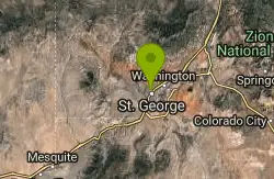
Dixie Sugarloaf / Dixie Rock
St. George, Utah
1.4 miles N of St. George, UtahHike near St. George, Utah
Full Listing
Hike
Last visited on 8 Apr 2018
Sand Hollow State Park
Hurricane, Utah
6.3 miles SW of Hurricane, UtahSand Hollow is the closest thing to a tropical paradise in the middle of the Utah desert, near Hurricane, Utah. It features a beach area, places to cliff jump, swim, and off-road with your ATV. There is seemingly no end of things to do at Sand Hollow.
First, there is the cliff jumping area located to the left of the parking lot of the entrance to the State Park. Local adrenaline junkies frequent the spot and can be seen doing tricks and flips as they jump from the rocks. Even if you don't consider yourself an adrenaline junkie, but want to challenge yourself and have some unique fun in the desert of southern Utah, cliff diving can almost certainly provide that sense of adventure to you.
Next, there the local beach off to the right side of the entrance where visitors can swim, paddleboard, canoe, and boat in the reservoir area. The beach can be crowded at times and the summer heat in Southern Utah can be intense from May to September. The best times to go to Sand Hollow State Park would be in the morning and in the evening. You may run the risk of the Park being crowded, but you would be able to better maximize your time while at the Park. Also be sure to bring plenty of sunscreen!
Last, but not least, if you have ATV's that you love to bring when you visit the desert, then Sand Hollow could be the place for you! With vast sand dunes and sandy roads to speed through, Sand Hollow could be the perfect place to bring your ATV's to see what they are made of.
There is an entrance fee to get into the Park at $10 per vehicle. The pass is good all day, allowing visitors to get a full day at the Park.
Let your inner adventure out and spend some time at Sand Hollow!

Hidden Valley Park
Rexburg, Idaho
1.3 miles E of Rexburg, IdahoSled near Rexburg, Idaho
Full Listing
Sled
Last visited on 16 Mar 2018
0.3-0.6 mi
 Full Listing
Camp, Cross-country Ski, Hike, Sled
Last visited on 1 Jan 2018
Full Listing
Camp, Cross-country Ski, Hike, Sled
Last visited on 1 Jan 2018
Bear Gulch
Ashton, Idaho
9.7 miles NE of Ashton, IdahoBear Gulch is an abandoned ski hill out of operation since 1969.
While the vegetation is beginning to take over, there's still some great sledding to be had. It's just far enough into the hills that there's plenty of snow all through the winter and often from Fall to Spring. The most popular sledding run is on one of the overgrown ski runs. Starting above the parking lot it goes down through a "no motorized vehicles" gate and on down to the creek and old ski lift. Most people stick to the upper portion, especially with smaller children. However, there are a range of heights to start from so there really is something for all ages. The lower portion is faster and windy with usually a decent enough trail cut out that it guides you through every twist and turn all the way to the bottom. Being able to turn isn't essential but you may feel like slowing down or even stopping. Just be careful not to stop in front of somebody else. The hike up is pretty long and a little steep. Be sure to stay out of the way of other sledders coming down.
0.4-0.5 mi
 Full Listing
Mountain Bike
Last visited on 23 Nov 2017
Full Listing
Mountain Bike
Last visited on 23 Nov 2017
Mountain Ranch Bike Park
Eagle Mountain, Utah
3.3 miles NE of Eagle Mountain, UtahMountain Ranch Bike Park takes great advantage of that otherwise unusable strip of land underneath large power lines. There is tons of single track thoughout the area but the bike park offers some great features. At the base, there's a skills park for all ages to practice jumps, drops, ladders, and berms.
The first skills section you'll see is the ladder park. With over 400 feet of ladders and rock features, you'll be able to practice everything from basic balance to balancing on berms and climbs to riding technical rock features and executing drops. There's even just some plain boards for practicing some skinnies.
The next park is a very small little bike park for the kiddies. It's complete with jumps and berms but nothing is over 2 feet high.
The most popular section of the skills park is the jump track which features 5 sets of table tops, each with 3 sizes of jumps. The first set has a jump to the side so you can gap over to the actual table top and the last of the larger jumps has a very small gap.
There are 3 official trails in the park. Each uses the same bike path and access road to get to the top and each of them ends back at the ladder park.
- 110 is rated Beginner and is flowy with ladders. There are a few jumps under 2 feet and a few optional ladder features.
- 220 is rated Intermediate and is actually fairly technical compared to Juniper, which is marked as Advanced. There are several optional ladders and several more technical areas of rock to climb and descend. Navigating the intermediate trail can be tricky as well as there are many optional routes that do not all lead back into the main trail. For the most part, there isn't a ton of slope up or down.
- Juniper is rated Advanced likely due to the slope and speed. You'll find plenty of flow, jumps, and speed. There are a couple of table tops and a couple of small kickers. At the beginning of the trail, there's a pretty serious drop with a rocky landing that leads immediately into a berm. After that, it's pretty mellow. There's not a lot of optional features but there are no gap jumps and nothing that couldn't be rolled over if it looked like it was too much.
Local Information
- Restrooms are located at Nolan Park (one block west and 1/2 block north) and at the gas station at the Pony Express, Ranches Parkway intersection.
- Parking Please do not park in front of private residences. If there is no parking on golden eagle please park by Nolan Park (one block West) Eagle Mountain and The Ranches are bike friendly communities with lots of trailways. Please consider riding your bike next time.
- Food and services are available at the corner of Ranches Parkway and Pony Express Parkway. The trail across the road to the north can take you there
- Please stay off of private property and electrical towers
- Trash cans are located in the skills area and at the trailhead. Please use them for all of your garbage needs.
- Get involved If you can volunteer some time for maintenance of this park, or you have any suggestions contact us at waftautah.com
Rules
- Ride at your own risk. Jumps and technical trail features in this park may be dangerous. Accidents and injuries can occur. Ride within your limits.
- This park is not supervised. You are responsible for your own safety.
- Protective helmets. Gloves knee pads, and elbow pads are strongly recommended.
- Park hours are dawn to dusk unless the area is posted closed for construction or repairs
- Bicycles only. No motorized vehicles are allowed.
- Ride responsibly. Stay in control of your bike at all times. Only ride features that match your ability.
- Use caution and know your limits. Start small and develop your skill level before advancing. Inspect all features and jumps before riding.
- Be considerate of neighbors and other park users, especially children.
- Ride only on designated areas and trails. If the soil is muddy please do not ride in this area.
- Rain and wind increase the risk of technical features and jumps. Please use extra caution in these conditions.
- Unauthorized features and jumps are prohibited. Please do not make alterations to the trail or park features. All changes must be approved and reviewed by Eagle Mountain City Parks Department.
- Ride don't slide. Skidding damages jumps and trails. Please ride responsibly.
- The City of Eagle Mountain is not responsible for injuries to park users or for damage or theft of personal property.
0.2-9.7 mi
 Full Listing
Hike, Horseback, Mountain Bike
Last visited on 4 Nov 2017
Full Listing
Hike, Horseback, Mountain Bike
Last visited on 4 Nov 2017
City Creek
Pocatello, Idaho
1.3 miles S of Pocatello, IdahoThe City Creek Management Area (CCMA) Trail System is a vast network of trails maintained by the City of Pocatello. There are trails to go up and others to come down. Most trails come back to the parking lot, making it much like a ski-hill setup, only without the lift and expense.
Trails
- City Creek Trail: (2.75 miles)
Main single track trail which meanders along City Creek. Total elevation gain for the Trail is 930 feet. - Lower City Creek Trail: (1.21 miles)
Lower portion of the City Creek Trail from the Grant Street Parking Lot to Bridge 10. Some rocks and obstacles are present as well as a few small steep grades. This section recommended as a Biker-One-Way-Uphill from bridge 1 to bridge 10. Use special caution at bridges 7, 8,& 9. - Upper City Creek Trail: (1.54 miles)
Upper portion of the City Creek Trail from Bridge 10 to the connection to Kinport Road. Some rocks, roots and obstacles are present as well as a few steep grades. Use caution for the hill section between bridges 10 & 11. - 911 & Lifeflight: (0.76 miles)
911 is a downhill only, classic CCMA roller coaster ride for skilled bikers. The adjacent Lifeflight trail is an escape route for 911, is less challenging, and bi-directional. - Bench Trail: (1.21 miles)
Alternate to the “up the gut” section of the City Creek Trail, this trail can be rocky and rutty. - Black Cairn: (1.37 miles)
Fast single track leading from the top of the Outlaw Trail towards the “old dairy”. Check your brakes! - Bump Trail: (0.65 miles)
Main single track connector to Cusick Creek. - Burrito: (0.71 miles)
Single track “side loop” around Death Valley. - Cusick Creek Road: (3.72 miles)
This is an alternate route to Kinport Peak, although the upper reach is very rocky and technical. Only the lower 2.13 mile section is within the CCMA. - Death Valley: (1.08 miles)
Challenging single track up a small ravine. - City Creek/Kinport Road: (5.38 miles)
The longest road/trail in the CCMA which accesses Kinport Peak. Only the lower 3.4 mile stretch is within the CCMA. - The Grove: (0.90 miles)
This serpentine, technical single track travels through an aspen grove and is a great alternative to the North Fork road for hikers/bikers. - Lichen: (0.39 miles)
Anice single track for hiking and biking, this trail winds through a shallow draw filled with flowers. - Mushroom: (0.87 miles)
Tough, single track alternative to the last mile of the Upper City Creek Trail. - North Fork: (1.92 miles)
Main motorized route north of City Creek. The majority of this route travels through BLM land which begins a short distance east of the cattle guard crossing. - Over the Top: (3.77 miles)
Challenging climb with switchbacks and views. - Prison Trail: (0.69 miles)
One of the original biking “loops”, this single track provides the most direct access to Cusick Creek via the Bump Trail. Although most of the trail is easy, watch for the steep section through Death Valley. - Serengeti: (1.23 miles)
This combination of single and double track provides motorized access to the southern portion of the CCMA. Tread lightly here as it travels through sensitive wildlife habitat. The length of South Serengeti is approximately 1.18 miles. - Sullivan’s: (1.20 miles)
Arguably the CCMA’s most scenic trail, this carefully carved, technical single track connects Serengeti to Mushroom and the main City Creek Trail. - Switchback: (1.55 miles)
This great climbing run connects Black Cairn to - White Cairn: (1.43 miles)
White Cairn: Fun, single track connector to Bridge 11.
City of Pocatello CCMA Trail Maps
- CCMA Trail Map (PDF) - Basic map with trail key (8 1/2 x 11)
- Alternative Satellite CCMA Trail Map (PDF) - Basic map with trail key (8 1/2 x 11)
- CCMA Trail Map Brochure (PDF) - Map with major trail descriptions and CCMA facts, trail designations and hints on how to get the most out of your trail experience (8 1/2 x 14)
2.7 mi
 Full Listing
Mountain Bike
Last visited on 2 Nov 2017
Full Listing
Mountain Bike
Last visited on 2 Nov 2017
Sidewinder Trail
Ririe, Idaho
6.5 miles E of Ririe, IdahoSidewinder's claim to fame is that it's on a South facing hill just above the Snake River. That means that when all the other trails in the Kelly Canyon Trail network are covered with snow and mud, Sidewinder is getting plenty of sun, keeping it dry earlier and later in the year. It's closed from December through April to accommodate wintering mule deer but is often rideable up until it's closed and as soon as its open.
The singletrack trail meanders through sagebrush for the first 1/4 mile before it gets into the switchbacks of which there are several. From there, the incline is pretty gradual and consistant until you get closer to the top. There are plenty of areas where it flattens out a bit for a little relief and several dips and even a little downhill. The downhill sections on the way up almost always precede a steeper uphill. It's a great way to get up a little speed to make the steep parts a little easier.
There's a little bench at the top of the trail where you can sit and enjoy the view before continuing to the ATV junction. Continuing upward on the ATV junction will connect you into the rest of Kelly Canyon's trail system. If it's wet, you'll find slimy clay mud. There are also sections of the trail that are covered with shale.
Going down makes it all worth it. Sidewinder is a great flow track with corners much tighter than you realized on the way up. There aren't a lot of well bermed corners so you'll see plenty of people go off the trail. Luckily, going off a corner usually just results in a ride through some sagebrush. You won't find any serious jumps but there's plenty of dips and turns to make for a great time.
Like any of the Kelly Canyon Trails, Sidewinder can get pretty dusty in the summer. It's best if you can ride it relatively soon after a light rain so it's just barely damp. The trail can get pretty crowded during peak times which can interrupt your climb momentum and your flow downhill. Please do your best to respect other riders.
11.9 mi
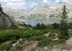
Island Lake
Pinedale, Wyoming
11.0 miles NE of Pinedale, WyomingBackpack, Hike, and Horseback near Pinedale, Wyoming
Full Listing
Backpack, Hike, Horseback
Last visited on 10 Aug 2017
5.7-8.1 mi
 Full Listing
Cross-country Ski, Mountain Bike
Last visited on 27 Jul 2017
Full Listing
Cross-country Ski, Mountain Bike
Last visited on 27 Jul 2017
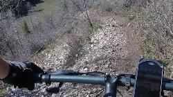
Space Cruz
Ririe, Idaho
9.0 miles E of Ririe, IdahoThe trail starts out with a really flowy singletrack then connects up to some ATV trails. On the single track, just stay on the main trail. There are several little splits several you can take that all come back together. If it splits off hard, stay on the main trail. These other routes aren't really optional challenges, just different routes. At the end of the singletrack section, there'll be a cattle guard and you'll come to a 'T'. Go left, then immesiately right. The trail is mostly downhill but there are a couple of pretty good climbs at this point. There are a lot of junctions but if you keep right at all of them from here, you'll make it out just fine. There are several small jumps on the trail. All in all, it's a pretty flowy track with some great berms. Don't run into any cows and go fast through the thistle patch near the top (it'll hurt less that way).
Jefferson County Lake (AKA Rigby Lake)
Rigby, Idaho
2.0 miles N of Rigby, IdahoRigby Lake has long been a favorite swimming hole for those in the area. The county has taken it well under its wing and made it a buzzing spot on any warm summer day. Along with the long standing bathroom facilities and volleyball court, there is now two playgrounds. The beach has been extended along almost the entire South shore and is now covered with sand perfect for sand castles or even burying kids in the sand. There are two floating docks on the West end of the lake that are great for jumping into the water. One of the docks even has a slide that will drop you out over the water for a small splash. There's often a food truck parked there now as well. There are several pavilions big and small and a campground on the North end of the lake.
There are bouys that divide the safe swimming zone from the open water where you'll find plenty of canoes, kayaks, and paddleboards.
The lake, parking lot, facilities, and surrounding area is now fairly well maintained. To maintain everything, there is a $6.18 per vehicle access fee or you can buy a season pass for $30 (As of 7/6/2017).
When the lake drains and/or freezes in the winter, this is also a great spot to go sledding. There is no fee to park here in the winter.
Monkey Rock
Saint Anthony, Idaho
4.1 miles SE of Saint Anthony, IdahoCLOSED. PSA: Monkey Rock is no longer open to the public. The owner has posted "No Trespassing" signs and is asking the Fremont County Sheriff's Office to assist with keeping people out of their private property. We would like to remind those who may choose to ignore the "No Trespassing" signs that trespassing is a misdemeanor and will not be tolerated.
Full Listing
Swim
Last visited on 4 Jul 2017
Monkey Rock features a beautiful waterfall you can wade right up to during the summer. Just under the waterfall is a great spot to wade around in or even some shallow swimming pretty good for small children. Maybe you just want to take advantage of the great bank to bask in the summer sun. The water temperature is fairly cool, which by no means is unwelcomed during the hot summer months. You'll get used to the water fairly quickly once you're in. The waterfall is a fun feature at Monkey Rock, not to mention a popular engagement photo backdrop. The name "Monkey Rock" is derived from the "monkeys" who jump off the rocks at the top of the falls to the pool below. Though not a great height, it's important to be careful and only jump into areas clear of rocks and other hazards and where the water is deep enough that you won't hit bottom when you jump. There really isn't a safe spot to jump from the falls as it doesn't usually get more than 5 feet deep.
The real jumping location is off the Hog Hollow Bridge up the road from the waterfall.
PLEASE NOTE: On the roads leading to Monkey Rock, the speed limit is 35 mph for the last mile. There are kids, cows, horses, and dogs along that road and many people tend to speed going to and from Monkey Rock. Please slow down and stay safe.
0.6 mi
 Full Listing
Dive, Hike, Mountain Bike, Snowshoe, Swim
Last visited on 3 Jul 2017
Full Listing
Dive, Hike, Mountain Bike, Snowshoe, Swim
Last visited on 3 Jul 2017
Packsaddle Lake
Tetonia, Idaho
9.3 miles W of Tetonia, IdahoPacksaddle is one of the less well known lakes/trails in the area. If you've got a good offroad vehicle, you can probably make it all the way to the end of the road, otherwise, it's just an extra 0.5 miles up the hill. Even to get to that point though, you may push the limits of your car or mini van and be required to do some pretty technical driving. There are plenty of good spots to park along the road if you decide that's as far as you can drive. The descent to the lake is pretty steep (300ft elevation drop) but less than a 1/2 mile to the lake. You'll be able to see the lake from the top of the trail. There's a little camp area on the eastern edge of the lake.
Mountain Bike Trail (From Lower Trailhead)
It starts on a slight incline and then gets gradually steeper. Trail is pretty smooth. After a tough climb, you get a downhill followed by a field. Then there's a fork in the road. If you actually want to get to the lake, take a left at the fork. Climb some more. View the beautiful Tetons on your left. You'll come to a clearing at the top. If you look down to the left, the lake is between the trees down the steep decline singletrack. Don't ride right into the lake. It's freezing, and does a quick dropoff. Courtesy of Singletracks.com
4.7 mi
 Full Listing
Backpack, Camp, Hike, Hot Springs, Mountain Bike, Swim
Last visited on 10 Jun 2017
Full Listing
Backpack, Camp, Hike, Hot Springs, Mountain Bike, Swim
Last visited on 10 Jun 2017
Fifth Water Hot Springs
Provo, Utah
19.0 miles SE of Provo, UtahAKA Diamond Fork Hot Springs
A beautiful drive and a 2.5 mile hike along the river will end you at an amazing set of hot springs that's well worth the trip. There's a variety of man-modified rock pools of varying temperatures up to 108°. Watch out for snakes. Depending on when you go, there can be a lot.
There are multiple sets of pools. As soon as you come into view of the falls, you'll see a couple of pools that seem to be a little raised above the creek. There are several pools close to the waterfall, including some very shallow pools and some where it's easy to move the rocks around to form your own. If you continue beyond the waterfall, you'll find a couple of more secluded pools. Make sure to go behind the waterfall but be careful of some of the more slippery rocks.
There's no good place to change once you get to the springs so you may want to plan to hike in your swimwear. If you come on a sunny day, it's easy to dry off before walking back. If you're a tenderfoot, be sure to bring some sort of footwear for the water so you can go wherever you like.
Like most locations, the hot springs more popular on the weekends so plan accordingly.
Roundtrip: 5 miles
0.1 mi
 Full Listing
Cave, Hike
Last visited on 3 Jun 2017
Full Listing
Cave, Hike
Last visited on 3 Jun 2017
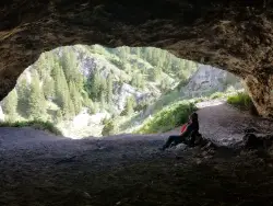
40 Horse Cave
Firth, Idaho
11.9 miles E of Firth, IdahoThe naming of the cave comes from a story of two men who were caught in a bad storm. Upon hiking, these two guys were able to find the cave. One of them commented to the other, "This cave could hold about 40 horses." Another legend tells of a theif that hid 40 horses in the cave to avoid capture. Either way, there's no doubt that 40 horses would fit in the cave.
The hike up to the cave is steep. Elevation gain may only be about 100 feet but even the longest trail is still just under 500 feet (0.1 mile) to the cave. Once you find the trailhead, it's really easy to find. You'll just hike uphill until you come to a large opening in the mountain. The shorter trail has a lot more shale and is a pretty difficult scramble. The longer trail is still steep and difficult but there is much less shale.
Flashlights aren't required, as the cave is only about 50 feet deep. There are a few corners of the cave that are a little more fun to explore with a flashlight.
At the bottom of the trail is a culvert and when the water is higher, it's a fun place to splash around after the hike. You'll see a trail in the willows on the SouthEast side of the road near the culvert. If you follow that trail only about 100 feet of easy hiking, you'll find a smaller cave.
0.4-0.7 mi
 Full Listing
Mountain Bike, Sled
Last visited on 9 May 2017
Full Listing
Mountain Bike, Sled
Last visited on 9 May 2017
Rexburg Bike Park
Rexburg, Idaho
0.8 miles NE of Rexburg, IdahoIt's a small but great bike park for all ages; if you are a beginner, then this is the bike park to go to. The mounts are a decent size and approximately 4-6 mounts in different sizes for the kids. Want to spend time with friends and/or family while doing something awesome? Do your kids have nothing to do? Come to the Rexburg bike park!
Located in the back of the water park Rexburg Rapids, the Rexburg bike park is a fun place for people of all ages to ride their bikes during the open season.
There are mounts of many different sizes (small, medium and a few large ones.) Being bored is not cool! Bring your family and friends, have a cookout and ride mounts with your bike! Always wear protective equipment before riding.
By the way, do you love sledding in the winter? Also, in the winter time, the mounts are covered with snow; which makes for great sledding with family and friends. Come and have fun!
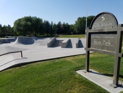
Claire Boyle Skatepark
Rexburg, Idaho
0.5 miles NW of Rexburg, IdahoThere are 2 bowls right next to each other plus several boxes quarter pipes and rails. It's not huge but it's also rarely crowded. It's all concrete with metal edge, specially for grinding.
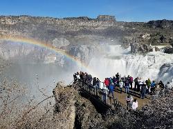
Shoshone Falls Park
Twin Falls, Idaho
3.7 miles NE of Twin Falls, IdahoThe view of Shoshone Falls is beautiful year round but it is simply breathtaking during spring runoff when the water levels are high and they roar so hard you can feel the mist hundreds of feet above the water. There are multiple platforms for viewing as well as information placards and a little gift stand. The park is owned and managed by the city of Twin Falls who charge a fee of $3 per carload (as of 4/1/2017).
The canyon rim trail goes up the canyon wall on the Southwest end of the falls and continues along the rim taking you to the site of Evel Kneival's 1974 attempt to jump the Snake River Canyon. To the jump site and back is about 2.5 miles round trip.
×


