


Dixie Sugarloaf / Dixie Rock
St. George, Utah
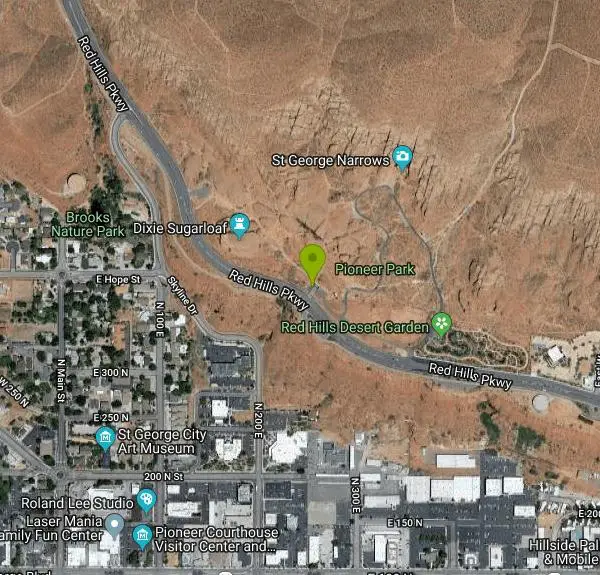
| Address: | Red Hills Pkwy, St. George, UT 84770, USA |
| GPS: |
37°6'53.3"N 113°34'40.5"W Maps | Directions |
| State: | Utah |
| Trails/Routes: | 0.3 mi |
Hike
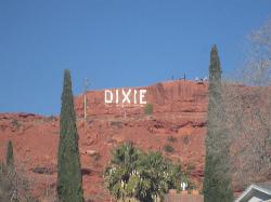
Dixie Rock, also known as the Dixie Sugarloaf, is St. George's most recognizable landmark: a rounded, rust-red sandstone prominence rising above the north edge of town with the word "Dixie" painted in enormous letters across its flank. Set in the 52-acre Pioneer Park on Red Hills Parkway, it delivers something genuinely rare, a classic southern Utah red-rock experience with big views, reached by a short walk from pavement minutes from downtown.
The lettering has a history of its own. A photograph from 1914 shows the rock painted with "1914 D" and a class of students posed on top beside a ladder, and the word "Dixie" was later painted over that early work, becoming the landmark St. George knows today. The formation earned its other nickname honestly, its rounded shape resembling an old-time brick of sugar. The hike to the top is a 1.3-mile loop on a well-maintained, moderately easy trail, with some steep scrambling near the end and a small bridge spanning a gap in the rocks to deliver you onto the summit. From up there the payoff is enormous for the effort: sweeping views over downtown St. George, out to White Dome, and on a clear day all the way to Zion National Park and into Arizona.
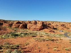
The park around it is a playground of slickrock. Pioneer Park's rock formations are made for scrambling and exploring, and the trail network branches out to a surprising collection of finds, including access toward the Red Cliffs Desert Reserve, a Boy Scout Cave, slot canyons, and a historic pioneer cabin. Kids love it, and it's the kind of place where an hour turns into three because there's always one more crack or dome to poke into.
Facilities are excellent for a city park: barbecues, a covered pavilion that can be reserved, drinking fountains, restrooms, picnic tables, parking, a trailhead and walking paths. It's free. To find it, take exit 8 off Interstate 15 onto St. George Boulevard toward downtown, turn right immediately on 1000 East, then left onto Red Hills Parkway.
This is exposed slickrock in one of the hottest corners of Utah, where summer temperatures routinely pass 100 degrees with essentially no shade, and the scrambling near the top involves real drop-offs, so grippy shoes, plenty of water and an early start all matter more here than the short distance suggests. Fall through spring is the pleasant season.
Bring water, sun protection, shoes with sticky soles for the sandstone, and a camera for sunset, which sets the whole formation glowing. For a landmark hike you can do in an hour with a view stretching to Zion, Dixie Rock is the best introduction to St. George there is.
More Information
St.George, UT
Copy and paste this code into your website.
https://sgcityutah.gov/business_detail_T18_R64.phpBe courteous, informed, and prepared. Read trailhead guidelines, stay on the trail, and don't feed the wildlife.
Read More- Plan Ahead and Prepare
- Travel & camp on durable surfaces
- Dispose of waste properly
- Leave what you find
- Minimize campfire impacts
- Respect wildlife
- Be considerate of other visitors
Directions
From St. George, Utah
- Head north on S 700 E toward E 600 S (0.9 mi)
- Turn right onto E 100 N/St George BlvdPass by McDonald's (on the right)(0.2 mi)
- Turn left onto N 900 E (0.2 mi)
- Turn left onto E Red Hills Pkwy (0.8 mi)
- Turn right (75 ft)
- Turn left (23 ft)
 The word DIXIE painted across the face of the Sugarloaf above St. George courtesy of Einbierbitte↗ (CC0↗)
")
 The Sugarloaf newly painted with DIXIE, written over the 1914 lettering added by freearenas (Public Domain↗)
") Red sandstone formations at Pioneer Park, home of Dixie Rock courtesy of bob↗ (CC BY-SA 4.0↗)
Red sandstone formations at Pioneer Park, home of Dixie Rock courtesy of bob↗ (CC BY-SA 4.0↗)
")
Other Hiking Trails Nearby
St. George Narrows
St. George, Utah
0.2 miles NEA dry, 0.17-mile slot canyon in downtown St. George inside Pioneer Park — an easy intro to canyon exploration with arch, cabin, and desert garden trails in the same park.
Hike 0.5-15.1 mi
Green Valley Trail System
St. George, Utah
5.1 miles SWAn interconnected Southern Utah trail system with everything from the sandy Bearclaw Poppy and slickrock Zen Trail to technical Snake Pit and Rattlesnake routes — endless combinations for all mountain bike skill levels.
Hike, Mountain Bike 11.3 mi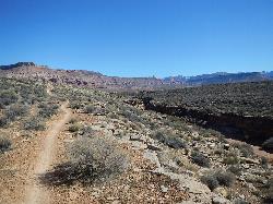
Grapevine Trail
Washington, Utah
5.4 miles NEA 5-mile out-and-back trail connecting southern Utah desert, paved paths, and rocky terrain before ending at Grapevine Spring — a small waterfall cascading down red rock.
Hike, Mountain Bike 9.4 mi
Church Rocks
Washington, Utah
5.5 miles EA nearly 6-mile red rock ride near St. George winding through sandy desert washes and smooth slick rock — a great practice run before tackling Moab's Slick Rock Trail.
Hike, Mountain Bike 0.2-0.4 mi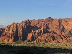
Snow Canyon State Park
St. George, Utah
7.0 miles NWA smaller, quieter cousin to Zion, Snow Canyon offers mountain biking, rock climbing, caving, and desert exploration near the Tuacahn amphitheater outside St. George.
Cave, Hike, Mountain Bike, Rock Climb 0.7 mi
Snow Canyon Lava Caves
St. George, Utah
8.2 miles NWSeveral lava tubes in Snow Canyon State Park with an open entrance, narrow passages, and a large final room — plus five Native American petroglyph sites nearby on the trail.
Cave, Hike 0.7 mi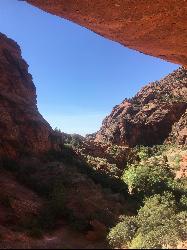
Red Reef trail
Hurricane, Utah
12.1 miles NETwo miles of red slickrock, a slot canyon, a spring waterfall, and ancient Anasazi hieroglyphs in a small cave make this an exceptional family-friendly desert hike.
Hike 3.4 mi
More Cowbell
Virgin, Utah
18.6 miles EA smooth 2.7-mile beginner mountain bike loop through red Utah desert bluffs — mostly flat singletrack that's also great for hikers and connects to more challenging trails.
Hike, Mountain Bike 5.1 mi
Dead Ringer
Virgin, Utah
18.6 miles EA 5-mile desert singletrack starting from the JEM trailhead near Virgin, winding through ups and downs and bottoming out in the bumpy, hoof-print-marked Goosebumps area.
Hike, Mountain Bike 7.0 mi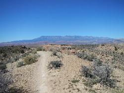
J.E.M. Trail
La Verkin, Utah
20.8 miles EA 13.27-mile round-trip mountain bike trail near Hurricane, Utah with jarring terrain and sharp turns near sheer cliffs — beautiful red rock and desert views reward the effort.
Hike, Mountain Bike 11.6 mi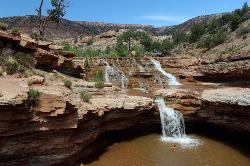
Toquerville Falls
La Verkin, Utah
22.2 miles NELedges, falls, a ladder to the best jumping spots, and a 7-foot-deep pool at the end of a 5.5-mile sandy desert drive — but stay away from the brittle, injury-prone cliff edges.
Dive, Hike, Mountain Bike, Swim 0.1 mi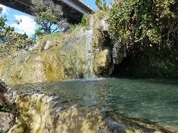
Little Jamaica aka Desert Springs
Littlefield, Arizona
24.2 miles SWA tropical-feeling warm spring waterfall and pool in the Arizona desert, with plant-covered grottos and a family-friendly depth that never exceeds five feet.
Hike, Swim 3.3 mi
Guacamole Mesa
Virgin, Utah
26.6 miles EAn 11-mile advanced desert loop on Guacamole Mesa outside Zion NP — a steep, narrow climb with gorgeous red rock views gives way to a flat desert finish; avoid in rain.
Hike, Mountain Bike 7.5 mi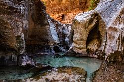
The Subway
Apple Valley, Utah
31.9 miles NEA slot canyon in Zion where you hike, swim, and rappel through majestic tunnels and lava tubes — one of the most magical canyon walks in all of Utah.
Canyoneer, Hike, Swim
Zion National Park
Hurricane, Utah
33.3 miles EWind, water, and ice sculpted Zion's iconic red sandstone buttes, bends, and mounts into one of the most breathtaking and irreplaceable landscapes on Earth.
Camp, Hike, Mountain Bike, Swim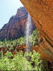
Emerald Pools Trail
Hurricane, Utah
35.3 miles EThree algae-tinted pools carved into Zion's canyon walls glow with an otherworldly emerald color fed by near-constant waterfalls — though swimming and wading are strictly prohibited.
Hike
The Grotto Trail
Springdale, Utah
35.8 miles EThe Grotto Trail is an easy, nearly level half-mile Zion walk linking Zion Lodge and The Grotto — and the gateway to Angels Landing.
Hike 2.6 mi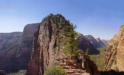
Angels Landing
Springdale, Utah
35.8 miles EZion's most iconic strenuous day hike — 21 steep switchbacks, dramatic Scout Lookout views, and a narrow chain-assisted ridge with 1,000-foot drop-offs to an unmatched canyon summit.
Hike 3.6 mi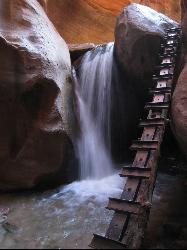
Kanarraville Falls
Kanarraville, Utah
36.6 miles NEA slot canyon hike through ankle-to-knee-deep water to twin waterfalls, with a natural sandstone slide into a refreshing swimming hole halfway through the route.
Hike, Swim
Riverside Walk
Springdale, Utah
36.7 miles EA flat, paved riverside walk through Zion's desert swamp oasis, with hanging gardens on the cliffs and the option to continue into The Narrows — check flood conditions first.
HikeNearby Campsites

Sand Hollow State Park
Hurricane, Utah
10.8 miles EA desert reservoir near Hurricane with a cliff-jumping area, a sandy beach for swimming and paddleboarding, and vast sand dunes for ATVs — southern Utah's desert playground.
Camp, Canoe, Dive, Kayak, Swim
Zion National Park
Hurricane, Utah
33.3 miles EWind, water, and ice sculpted Zion's iconic red sandstone buttes, bends, and mounts into one of the most breathtaking and irreplaceable landscapes on Earth.
Camp, Hike, Mountain Bike, Swim


