


Refine Search
- hike 12
- swim 7
- camp 6
- backpack 6
- dive 3
- rock climb 3
- cave 2
- canoe 2
- mountain bike 2
- horseback 2
- kayak 1
- sled 1
- hot springs 1
- skateboard 1
18 locations
Add Location
 Full Listing
Show more
Skateboard
Added on 3 Jul 2019
Full Listing
Show more
Skateboard
Added on 3 Jul 2019
 Full Listing
Show more
Camp, Canoe, Dive, Swim
Added on 13 Apr 2017
Full Listing
Show more
Camp, Canoe, Dive, Swim
Added on 13 Apr 2017
 Full Listing
Show more
Camp, Hike
Added on 13 Apr 2017
Full Listing
Show more
Camp, Hike
Added on 13 Apr 2017
 Full Listing
Show more
Backpack, Dive, Horseback, Swim
Added on 11 Apr 2017
Full Listing
Show more
Backpack, Dive, Horseback, Swim
Added on 11 Apr 2017

Full Listing
Show more
Rock Climb
Added on 7 Apr 2017
 Full Listing
Show more
Dive, Swim
Added on 2 Apr 2017
Full Listing
Show more
Dive, Swim
Added on 2 Apr 2017
0.2-0.5 mi
 Full Listing
Show more
Camp, Hike, Mountain Bike, Sled
Added on 26 Jun 2026
Full Listing
Show more
Camp, Hike, Mountain Bike, Sled
Added on 26 Jun 2026
Eagle Park
Rexburg, Idaho
0.9 miles N of Rexburg, IdahoEagle Park is a little urban oasis. Once you drive in to this cottonwood forest along the river, you may forget that you're still inside Rexburg city limits. You can camp, picnic, throw rocks in the river, fish, mountain bike, or just go for a walk along the trail or road. All sites have picnic tables, fire rings, and tent pads. Just off the main parking lot is a nicely mowed grassy area that is a popular dog park. On the West end of the parking lot, you'll find a multi-use trail that will take you almost the entire length of the park.
Mountain Biking/Hiking/Walking
The trail system at Eagle Park is maintained in part by Free Arenas. If you have any would like to get involved or just want to share your thoughts on how to improve it, email trailbuilding@freearenas.com.
Tenderfoot is primarily a mountain bike trail. The trail runs back behind most of the campsites. While it's built for mountain bikes, it's usually great for a nice quiet walk as well, and arguably the best way to see the park. This 0.5 mile trail is rated Easy but is about as tough as an easy trail can get. It's pretty mellow but does have a couple of very short ups.
Taut-line is cut into the slope along the fence line. It begins on the embankment at the West end of the campground and goes for 0.4 miles before meeting back up with Tenderfoot. The Northwest section is the longest section of trail in Eagle Park and is cut into a steep slope above marsh and ponds. It is generally downhill from the West end but has plenty of up and down. Towards the middle of the trail, there is a berm and a couple of table top jumps. The section South of the Tenderfoot junction was an Eagle Project completed by Ian Hoffman and his volunteer crew. The trail continues to cut up and down the side hill with a fun rock berm and a rock garden. The end drops in to connect back to Tenderfoot right near the junction with Bugler. The trail is a one-way trail from West to East and has short climbs and fun decents. Because it's much higher than the Tenderfoot Trail it parallels, Taut-line does not flood and actually bypasses the flood areas of Tenderfoot. Because the trail does go along a steep slope on the West end, remember to fall uphill. This trail is rated Intermediate.
Bugler drops off the Tenderfoot Trail and runs down and around a small pond just off the main lawn. There's a few decents, climbs, and berms adding a little bit of speed and a little more difficulty.
Jamboree drops off the Eagle Park Road near campsite 19 and continues down along the river to the old campsite 14 that's now a disc golf basket. This trail rolls back and forth through a trough of sorts with some jumps along the edges and potential for many more. It seeps ground water when the water is higher and is completely flooded in May/June when the river is really high. When it's dry though, it rides decently fast and is a lot of fun!
Skills Park Along the Tenderfoot Trail and just off the lawn is a skills park built as an Eagle Scout project by Erik Hurst and other volunteers. It features a large wrap-around berm on the north end, raised skinnies made of 2x8, 2x6, and 2x4 treated lumber, a ladder a-frame, a rock garden, and a see-saw.
While not all trails are intended to bi-directional and multi-use, they are all used as such so please be aware of others on the trail.
Looking for a little longer hike or ride? Go to the Northwest end of the park and you'll find an old embankment road that follows the airport fence line to the Nature Park. It's pretty popular to loop both parks together.
Sledding
There's some mounds above a bench that can be used as a sledding hill area just off the main grassy area. It's a terraced hill with a couple set runs and then quite a bit of open hill as well. Elevation is only about 20 feet from top to bottom but there's plenty to keep kids busy for awhile. There's even a more difficult run that includes jumps and drops for snowboards. The terrace trails are better when the snow's a little bit icier but the small hills are great for little kids that wnat to avoid the more popular hill at Smith Park
Camping
Picnicking is free but there is a fee for camping. Overnight camping fee is $10.00 per space paid via rexburg.org. All fees are used for future picnic tables, restrooms and other park improvements. The camp fee for boy scout troops may be waived as long as they perform an approved 1 hour service project to the park while camped here. Picking up garbage and pulling weeds are always approved. Weeds that need pulled include hounds tongue, cocklebur, bull thistle, and the occasional stinging nettle.
Posted Eagle Park Rules
- No RVs in park
- No motorcycles, scooters, or ATVs on park roads
- 7 day camping limit
- Tents only on designated tenting pads
- Fires in designated fire pits only. No non-burnable items in firepits.
- No smoking, tobacco, or alcoholic beverages
- Pets on leashes only. (All pet droppings to be put in bags for droppings)
- All garbage to be put in garbage cans. Pack it in - Pack it out.
- No firearms, firecrackers, or explosives
- Avoid loud music and noises — Be respectful of other campers
To reserve an entire shelter, call City Hall at 359-3020. Reservation fee is $25 per half day.
This is a community service project of Free Arenas, the Madison Lions Club, Trails of Madison County, the City of Rexburg, and numerous Eagle Scouts in the Yellowstone District of the Grand Teton Council, BSA. Constructed 2001-2005.
Please respect the flora and fauna and practice the Outdoor Code. This park only exists because of volunteer service from many in the community. Please, don't be afraid to help out by collecting some hounds tongue, cocklebur, and bull thistle. If you're looking for ideas for a bigger service project, contact trailbuilding@freearenas.com
3.6 mi
 Full Listing
Show more
Canoe, Hike, Kayak, Swim
Added on 5 Aug 2019
Full Listing
Show more
Canoe, Hike, Kayak, Swim
Added on 5 Aug 2019
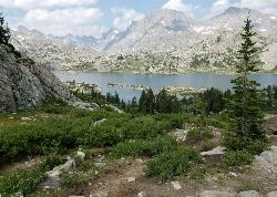
String Lake
Alta, Wyoming
16.4 miles NE of Alta, WyomingString Lake is a shallow lake that connects Leigh Lake and Jenny Lake at the base of Mount St. John and Rockchuck Peak. From the lakeshore, you can also take in beautiful views of Teewinot and Mt. Moran. The shallow lake is much colder than the glacier lakes on either side. The warm water makes it great for a swim and there's a lot of great areas for kids to wade in. Got a Kayak or Canoe, you'll love how clear the water is as you'll be able to see the bottom anywhere on the lake. It's also a great way to access Leigh Lake and Jenny Lake to do some boating on more open waters. You can put in at String Lake, boat to an end, and then portage to the connecting lake at a much less congested part of the lake.
Rather go for a hike? The String Lake Trail loops around the lake and far enough up the hill that you can get great views of String Lake. Come a little later in the summer and enjoy wild berries along the Northern half of the loop. Stay away from anything that's bright red though. If you're looking for something bigger, the String Lake Trail connects into trails into Paintbrush Canyon, Jenny Lake, and Leigh Lake. The Leigh Lake connection is right at the north end of the lake on the East side of the bridge. From there it's 0.1 miles to the Leigh Lake portage and you will be doing yourself a huge disservice if for some reason you decide not to take this detour. At that point on Leigh Lake, you'll find a tiny little sandbar with lots of rocks sticking up out of the water for hopping around and some amazing views. The portage is only a couple hundred feet away from Boulder Island which beautifully frames the view of Mt. Moran towering over the peaceful lake.
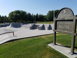
Claire Boyle Skatepark
Rexburg, Idaho
0.5 miles NW of Rexburg, IdahoThere are 2 bowls right next to each other plus several boxes quarter pipes and rails. It's not huge but it's also rarely crowded. It's all concrete with metal edge, specially for grinding.
0.6-2.0 mi
 Full Listing
Show more
Camp, Cave, Hike
Added on 23 Oct 2017
Full Listing
Show more
Camp, Cave, Hike
Added on 23 Oct 2017
North Menan Butte ('R' Mountain)
Menan, Idaho
4.5 miles N of Menan, IdahoThe North Menan Butte is more commonly known to the locals and college students as R Mountain. Many kids know it better as Ou'R' Mountain. The butte is a rare and unique geological area and provides a great volcanic hike.
There's a paved parking lot and a vault toilet at the West trailhead. The first few hundred yards are well-maintained gravel and sand paths and the further you get, the less defined the trail gets, though it is relatively easy to find and follow. The switchback trails (South and West) are marked by sections of log fences. Towards the top of the West switchbacks, there's a chain handrail. It gets a little steep so you'll want some shoes with some grip. The sand on the rock makes it pretty slippery in the steeper parts. You'll get better grip after a good rain. Once you get up to the top, there's an informational placard. From there, it's easy to hike the rim and get an awesome view of the valley including Rexburg, Henry's Fork, and the Snake River.
It's a great hike for a small family or just a quick hike for a date. Even going up the West switchbacks and around rim, including the 'R', and back down the same way is only 3.5 miles (longest route) so you can do it pretty quick if you want. There's so much to look at that you could also spend hours climbing rocks, exploring caves, and playing around "The Ampitheater". If you just want to get to the 'R' as quickly as possible, you can do the hike in as little as 2 miles roundtrip.
Distances:
- West trailhead up the face to the rim: 0.5 miles
- West trailhead up the switchbacks to the rim: 0.75 miles
- West trailhead, from reaching the rim to 'R': 1 mile
- South trailhead to the rim: 0.3 miles
- South trailhead, from reaching the rim to 'R': 0.75 mile
- Through the caldera: 0.6 miles
- Around the rim: 2 miles
- Rim to 'R': 500 feet
There are no fees. Camping is allowed up to 5 nights but fires must be in an elevated fire pan and all the ash must be packed out.
Posted regulations:
- No motorized vehicle use
- Discharging of weapons or fireworks is prohibited
- Open fires are permitted only with an approved elevated fire pan and ash removal
- Burning pallets, tires, wire, plastic, glass, metal, magnesium, or hazardous material is prohibited
- Cutting or damaging vegitation is prohibited
- 5-day camping limit
11.9 mi
Island Lake
Pinedale, Wyoming
11.0 miles NE of Pinedale, WyomingBackpack, Hike, and Horseback near Pinedale, Wyoming
Full Listing
Show more
Backpack, Hike, Horseback
Added on 18 Sep 2017
Horseshoe Lake
Ashton, Idaho
18.3 miles E of Ashton, IdahoHorseshoe Lake is a tranquil, tucked-away gem hidden in the Caribou-Targhee National Forest near Ashton, in the Island Park country of eastern Idaho. Ringed by pines and dotted with lily pads, this peaceful little lake is a favorite for those who like their water quiet, clear, and free of the roar of motorboats — in fact, motorized boats aren't allowed, which keeps the whole place serene.
Getting there is easy: a well-maintained forest road leads to the lake, with plenty of pull-outs and parking once you arrive. The shoreline slopes in gradually, making it great for wading and easy for kids to splash around, while the middle deepens into water plenty deep enough for swimming, paddling, and a refreshing dip on a hot summer day. A youth camp maintains a floating dock out toward the center that's often open for anyone to use — a perfect launch pad for jumping into the cool water.
It's an ideal spot for paddling. Bring a canoe, kayak, or paddleboard and you can glide across the glassy surface, weave among the lily pads, and explore the quiet coves at your own pace. Anglers do well here too, casting for trout in the calm water, and the surrounding forest offers dispersed camping for those who want to linger overnight under the stars.
Summer is the sweet spot, when the water warms up and the lily pads are in bloom. Pack a picnic, your paddle, and your swimsuit, and remember to pack out everything you bring in to keep this little lake as pristine as you found it.
Peaceful, scenic, and refreshingly uncrowded, Horseshoe Lake is the kind of hidden Idaho water that makes the search worthwhile.
0.8 mi
 Full Listing
Show more
Hike
Added on 13 Apr 2017
Full Listing
Show more
Hike
Added on 13 Apr 2017
Conant Creek Pegram Truss Railroad Bridge
Ashton, Idaho
5.0 miles SE of Ashton, IdahoAs part of the Rails to Trails project, this old railroad bridge has been transformed into a very safe little viewing experience for the whole family. You can drive right up to the bridge where there is a great little spot to park. Conant Creek meeanders hundreds of feet below the bridge. It's about 300 yards across and whether you're taking in the vibrant colors of spring, the beautiful fall colors, or the Tetons looming in the background, the view is spectacular.
The bridge is part of the 30 mile Ashton-Tetonia Trail. There is a smaller bridge less than 2.5 miles north on the trail.
3.8-6.4 mi
 Full Listing
Show more
Camp, Hike
Added on 13 Apr 2017
Full Listing
Show more
Camp, Hike
Added on 13 Apr 2017
Table Rock / Table Mountain
Driggs, Idaho
10.0 miles E of Driggs, IdahoAt roughly 11,100 feet, the flat-topped summit of Table Mountain serves up what many consider the single finest view of the Grand Teton anywhere — and one of the great day hikes on the quiet, western (Idaho) side of the range. From the broad mesa top you stand just far enough back to take in all three Teton peaks at once, yet close enough to pick out the detail on the Grand's sheer east face across the deep gulf of the canyon. It's a jaw-dropping payoff, and a hard-earned one.
The mountain holds a remarkable place in history. In 1872, pioneering survey photographer William Henry Jackson hauled his heavy glass-plate camera gear by mule to the top of Table Mountain and made the first photographs ever taken of the Grand Teton — images that helped introduce the range to the wider world and build support for protecting it. Jackson chose this peak precisely because its gentle western slopes could be reached without technical climbing, and that's still what makes the summit attainable for strong day hikers today.
The trailhead sits at the end of Teton Canyon Road outside Driggs and Alta, and nearly the entire route lies within the Jedediah Smith Wilderness of the Caribou-Targhee National Forest. There are two main ways up, and both climb over 4,000 feet. The Face Trail is the steeper, shorter option (about 3.5 miles one way), skipping the switchbacks to head more or less straight up. The Huckleberry (North Fork) Trail is longer but far more gradual (about 6.5 miles one way), following and crossing the North Fork of Teton Creek — handy spots to filter water — through meadows and, in mid-to-late summer, ripe huckleberries for those who beat the crowds to the bushes. Many hikers link the two into a big loop of roughly 11–13 miles, and tough-but-knee-conscious hikers generally prefer to climb up the steep Face and come down the gentler Huckleberry, sparing their knees the pounding of a steep descent. The lower trail is a delight in its own right, tracing rushing Teton Creek past a string of waterfalls.
The wildflowers here are spectacular. As the snow recedes, Table Mountain's meadows erupt in color — sweeping displays of lupine, arrowleaf balsamroot, and Indian paintbrush, with columbine in the shadier pockets and delicate alpine blooms up high. In the Tetons the canyon meadows tend to peak from early-to-mid July, while the highest ground saves its show for late July into August; even when snow still blocks the upper trail, the lower meadows near the trailhead put on an easy, photogenic display. It's one of the finest wildflower hikes in the region.
This is high, exposed country, so plan accordingly. At over 11,000 feet the air is thin and the weather changes fast: afternoon thunderstorms build quickly over the peaks in summer, so start early and aim to be off the open summit by early afternoon. Table Mountain is enjoyed year-round — it's a popular snowshoe and backcountry-ski destination in the snowy months. If you're after dry summer hiking, though, know that you're likely to encounter snow on the upper mountain before mid-July: early-season snowfields often begin around 9,500 feet with larger patches up high, and the Huckleberry side can hold avalanche debris and downed trees until it melts out. It's frequently still passable with the right footwear — just come expecting it. Conditions are typically most reliably snow-free from about mid-July through September. It's also easy to lose the trail, especially on the descent, so pay attention to your route and carry a map or GPS. Keep an eye out for wildlife, too — moose are a common sight in the canyon, and the area is home to the occasional mountain lion.
Bring layers, sun protection, plenty of water (and a filter), and sturdy footwear for the long, steep grade. You can check current conditions on the webcams at tetoncam.com before you drive up. Backpackers sometimes camp in the meadows below the summit to catch the Grand at sunrise — an unforgettable sight — while following Leave No Trace and wilderness regulations. However you do it, Table Mountain earns its reputation: a leg-burning climb to a mesa in the sky, carpeted in wildflowers, with the Grand Teton filling the horizon just as it did for Jackson a century and a half ago.
Big Springs
Island Park, Idaho
7.6 miles NE of Island Park, IdahoThere's also a great little walking trail along the river with placards that tell about the ecosystem and history of the area. There's about a 1/2 mile that's paved and then a 1/2 mile of dirt trail. The trail is NOT a loop. The trailhead is on the South West side of the bridge. There's a great spot to feed the fish under the West side of the bridge so bring some quarters to buy fish food. The trail to Johnny Sack's Cabin is on the North Side of the Cabin.
Campground (Fee Required)
This campground Is located on the Ashton·lsland Park Ranger District, comprising nearly 650,000 acres of National Forest System lands. Numerous amenities are offered such as single and double sites which Includes fire rings. utlllty tables. picnic tables, and reslrooms. This campground is situated nen to the beautiful Henry's Fork shaded by Lodgepole Pines. Come In and relax with friends and family. Head on out and explore the Big Springs Interpretative Trail which starts at the bridge Just Outside the campground. Be sure to visit the historical Johnny Sack Cabin, offering a unique Insight Into the history of the Big Springs Area. Just follow the asphalt walkway which will take you to the cabin Just north of the campground. Explore the historical, cultural, geological, and recreational resources this area has to offer.
Take a scenic drive south along the Mesa Falls Scenic By·Way. Stop by the Mesa Falls Visitor Center for an interpretative tour and captivating view of Upper Falls. A two mile Interpretative hiking uall will offer you a view of Canyon Rim.
Length of Stay: Forest Order
Camping or occupying a Single site for a period longer than 16 consecutive days Is prohibited. After leaving a site, a minimum of 7 days Is required before any group or person(s) from that group may reoccupy their original location.
This limit of stay restriction Is necessary to reduce displacment of other Forest desiring to occupy a particular campsite, and reducing the opportunity for visitor or group of visitors from monopolizing a campsite for long periods time (in excess of 16 days).
Fire Safety: Only You Can Prevent Forest Fires
Make sure your fire is DEAD OUT
- NEVER leave a fire unattended.
- Keep your fires small. Firewood Is available for sale. See campground host.
- Check with campground host for current fire restrictions.
- Use existing fire rings. Scrape away litter end any other burnable material within a l0 foot-diameter circle surrounding the fire ring.
- Make sure all wood fits inside the fire ring.
- To put out a campfire, slowly pour water onto the fire and stir with a shovel until all material is cool to the touch.
- Do not bury your fire. The coals can smolder and re-ignite.
- Make sure the fire is dead out. Many wildfires have been caused by abandoned campfires.
Bear Country: Required Food Storage Order
Your Safety Is Important to Us
All food and other items that might attract bears must be stored where bears cannot access them at night and during the daytime when unattended. Attended means that a person is physically present within 100 feet and in direct sight of the food.
What are bear attractants?
- All food and anything that contacted food. This includes full or empty coolers, packaging, boxes, cans, bottles, dirty dishes and silverware, etc.
- All beverages and beverage containers, full or empty (including water)
- All garbage, food scraps, and cooking grease. Never dump grease, beverages, or scraps on the ground.
- Never leave garbage in your fire pit or outside.
- Pet food and pet food bowls.
- Gas cans.
- Grills. Burn grill for at least 5 minutes after use to get rid of any residues. Clorox the grease trap.
Anything with a strong odor is an attractant for bears. Attractants must be stored in a bear-resistant manner. If you are away from your campsite or asleep at night in your test/trailer/RV, these attractants MUST BE STORED. You may be fined if you do not properly store your attractants. If you cannot properly store your attractants, inform the campground host and a bear resistant container may be provided for you.
What is bear resistant storage?
Acceptable places to store and dispose of your attractants are inside a hard-sided trailer, an enclosed vehicle, inside a bear dumpster or trash can (this campground has bear-resistant dumpster). Coolers, tents, underneath your RV/trailer the back of pick-up trucks, boxes, beverage bottles, canned goods, soft-sided trailers, and other containers are not bear resistant. All garbage must go to bear-resistant dumpsters. Garbage must never be left outside unattended. If the dumpster is full, you must take your trash back with you and inform the campground host of the situation.
NOTICE: ATV and Motorcycle use is prohibited
ATVs and motorcycles are prohibited from use in this campground. The following are exempt:
- Licensed street legal motorcycles.
- Vehicles used by handicapped individuals.
- Vehicles used by campground hosts for their official duties.
ATVs and motorcycles may be trailered into the campground, kept in the campsite on a trailer, or parked at a location designated by the campground host.
Educate Yourself
Contact the Island Park or Ashton Ranger Station for information on which areas are open to ATVs.
If you have a Dog: Keep your pet secure at all times
In the national forest, you and your dog could meet people, horses, mountain bikes, ATVs, other dogs, and wild animals. Help make the outdoor experience enjoyable for you, your dog and all the forest's users by following these safety tips:
- Please remove all feces before vacating your site.
- Give your dog plenty of water and rest, and watch for signs of stress and fatigue.
- Keep your dog leashed and under control in campgrounds. Secure your pet in a shady spot and give it lots of attention to minimize barking.
- If you encounter wild animals, respect them by restraining your dog.
Fireworks are prohibited
Fireworks or other explosives are prohibited within campgrounds and other recreation sites.
Fishing Rules: A fishing license is required to fish in this forest
- A state fishing license is required to fish in this national forest.
- A fishing license can be purchased over-the-counter at various stores in the local area. For more information, contact Idaho Fish and Game.
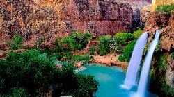
Havasu Falls Trail
Flagstaff, Arizona
89.4 miles NW of Flagstaff, ArizonaFew places in America inspire as much longing as Havasu Falls — the impossibly turquoise waterfall that has become a bucket-list icon of the Southwest. It lies deep in Havasu Canyon on the Havasupai Reservation, a side canyon of the Grand Canyon so remote it can be reached only on foot, by pack mule, or by helicopter. The Havasupai are the “people of the blue-green water,” and this is their homeland: a hidden desert oasis where waterfall after waterfall pours over red travertine cliffs into pools the color of the Caribbean.
That astonishing blue-green color is no trick of the light. Havasu Creek is spring-fed and saturated with calcium carbonate, which scatters sunlight into the vivid turquoise hue and, over time, deposits as travertine — building the smooth ledges, terraces, and natural dams that shape the pools. The mineral-laden water even rebuilds the falls after floods, which is why the canyon's cascades have shifted and been renamed over the years.
The falls come in a spectacular string below the village. Fifty Foot Falls and Navajo Falls — reshaped by a major 2008 flood and sometimes called Rock Falls — come first, followed by the star of the show: Havasu Falls itself, a roughly 100-foot plunge into a wide, swimmable turquoise pool that ranks among the most photographed sights in the world. Below the campground, Mooney Falls drops nearly 200 feet, the tallest in the canyon, and reaching its base is an adventure in itself: a steep scramble down through carved tunnels and along chains and slick ladders bolted to the dripping travertine wall. Farther on, about four miles past the campground, Beaver Falls tumbles in tiers through a lush grotto, and the truly ambitious can follow Havasu Creek roughly eight miles all the way to its confluence with the Colorado River.
Getting there is a genuine journey. The hike begins at Hualapai Hilltop and drops about 2,000 feet of switchbacks into the canyon, then follows a sandy wash 8 miles to the village of Supai — one of the most remote communities in the lower 48, so isolated that the U.S. mail still arrives by pack mule. From the village it's another 2 miles past Havasu Falls to the campground, which stretches about a mile along the creek between Havasu and Mooney Falls, with drinking water available at Fern Spring. All told it's roughly 10 miles each way, and the climb back out at the end is long and hot.
This is a permit-only destination, and getting one is the hardest part of the whole trip. The Havasupai Tribe requires a reservation for every visitor, and day hiking is not allowed — all permits are for a fixed three nights and four days. Camping permits run about $455 per person for the stay (a lodge in Supai is the pricier alternative), sold only through the tribe's official reservation website. New permits for the year are released on February 1 at 8:00 a.m. Arizona time and routinely sell out within minutes to a virtual line tens of thousands deep; a paid early-access window and a cancellation-transfer system offer other ways in. Do not hike in without a confirmed reservation — visitors without permits are turned around, and there are no walk-ups.
Come prepared and treat the canyon with respect. Summer is brutally hot, so many hikers walk the exposed miles at dawn and carry far more water than they think they'll need. Flash flooding is a serious, recurring danger here — the canyon has flooded and forced evacuations more than once — so watch the weather, camp on high ground, and heed any guidance from tribal rangers. Remember that this is tribal land and a living community, not a park: alcohol and drones are banned, pets should be left at home, and everything you carry in must be packed out. Book far ahead, aim for the milder weather of spring or fall, and Havasu Falls will repay the effort with one of the most unforgettable landscapes on the continent.
3.9-14.4 mi
 Full Listing
Show more
Backpack, Hike, Rock Climb
Added on 11 Apr 2017
Full Listing
Show more
Backpack, Hike, Rock Climb
Added on 11 Apr 2017
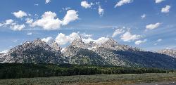
Grand Teton
Jackson Hole, Wyoming
17.6 miles N of Jackson Hole, WyomingAt 13,770 feet above sea level, the Grand Teton towers majestic over Southeastern Idaho and Western Wyoming, making it a life goal of many amateur climbers and outdoor enthusiasts.
The more popular routes all begin at the Lupine Meadows Trailhead and continue up through Garnet Canyon and The Meadows before splitting North. Most routes require rock climbing equipment and are only for skilled climbers. A guide is highly encouraged on any route. With 3k feet of exposure, falling from multiple segments of the trail would mean certain death.
Trailhead altitude: 6,732 ft
Summit altitude: 13,770 ft
4.7 mi
 Full Listing
Show more
Backpack, Camp, Hike, Hot Springs, Mountain Bike, Swim
Added on 8 Apr 2017
Full Listing
Show more
Backpack, Camp, Hike, Hot Springs, Mountain Bike, Swim
Added on 8 Apr 2017
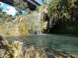
Fifth Water Hot Springs
Provo, Utah
19.0 miles SE of Provo, UtahFifth Water Hot Springs — better known to generations of Utahns as Diamond Fork Hot Springs — is one of the most beloved soaks in the state: a series of steaming, blue-green mineral pools tucked beside a waterfall in a pretty canyon southeast of Provo. A scenic drive up Diamond Fork Canyon and a riverside hike of about 2.5 miles each way lead to the reward, where hot water tumbles down a travertine hillside into a staircase of rock pools ranging from pleasantly warm to a toasty 105–110°F at the source.
The pools sit right where Fifth Water Creek meets a small waterfall, and part of the fun is choosing your spot. As you come into view of the falls you'll see a few pools perched just above the creek; more line the base of the waterfall, including shallow soakers and spots where you can nudge the rocks around to mix hot spring water with cool creek water and dial in your own temperature. Wander behind and beyond the waterfall and you'll find a couple of quieter, more secluded pools — just watch the slick, mineral-coated rock, which can be treacherously slippery. The water carries a faint sulfur smell and stains everything a milky blue-green; it's all part of the character.
A few practical notes make the trip smoother. There's nowhere private to change at the springs, so most people hike in their swimwear (and on a sunny day you'll dry off easily on the walk out). Bring water shoes or sandals if your feet are tender — the rocky pool bottoms and short scrambles are much friendlier with something on your feet. This is a relaxed, come-as-you-are place with a longstanding clothing-optional streak, so groups with kids may occasionally encounter suit-free soakers, especially on quiet weekdays.
Timing matters more here than at most hikes. The Diamond Fork Road gate closes for winter (typically from around November into late spring), and when it's shut the hike balloons to roughly 12–13 miles round trip — a popular but serious snowshoe or ski outing rather than a casual stroll. When the road is open, it's about a 5-mile round trip. Fall, winter, and spring are the sweetest seasons: cooler air makes the hot water far more inviting and the crowds thinner. The springs are busiest on weekends and holidays, so go early or midweek if you can, and note that a trailhead parking fee has been proposed for this popular spot, so come prepared for one.
Come prepared and tread lightly. Rattlesnakes are active along the sun-warmed trail in the warmer months — on a hot day you may well spot several snakes, most of them harmless, so simply watch where you step and reach. Carry plenty of drinking water — a long hot soak is dehydrating — and pack out everything you bring; broken glass and litter have been a real problem here, and keeping this gem clean is on all of us. Dogs are welcome on the trail. With a little planning, Fifth Water rewards you with one of the finest hot-spring soaks in the Wasatch — a waterfall at your back, canyon walls above, and warm mineral water swirling all around.
Monkey Rock
Saint Anthony, Idaho
4.1 miles SE of Saint Anthony, IdahoCLOSED. PSA: Monkey Rock is no longer open to the public. The owner has posted "No Trespassing" signs and is asking the Fremont County Sheriff's Office to assist with keeping people out of their private property. We would like to remind those who may choose to ignore the "No Trespassing" signs that trespassing is a misdemeanor and will not be tolerated.
Full Listing
Show more
Swim
Added on 8 Apr 2017
Monkey Rock features a beautiful waterfall you can wade right up to during the summer. Just under the waterfall is a great spot to wade around in or even some shallow swimming pretty good for small children. Maybe you just want to take advantage of the great bank to bask in the summer sun. The water temperature is fairly cool, which by no means is unwelcomed during the hot summer months. You'll get used to the water fairly quickly once you're in. The waterfall is a fun feature at Monkey Rock, not to mention a popular engagement photo backdrop. The name "Monkey Rock" is derived from the "monkeys" who jump off the rocks at the top of the falls to the pool below. Though not a great height, it's important to be careful and only jump into areas clear of rocks and other hazards and where the water is deep enough that you won't hit bottom when you jump. There really isn't a safe spot to jump from the falls as it doesn't usually get more than 5 feet deep.
The real jumping location is off the Hog Hollow Bridge up the road from the waterfall.
PLEASE NOTE: On the roads leading to Monkey Rock, the speed limit is 35 mph for the last mile. There are kids, cows, horses, and dogs along that road and many people tend to speed going to and from Monkey Rock. Please slow down and stay safe.
1.9-2.9 mi

Full Listing
Show more
Backpack, Hike
Added on 8 Apr 2017
Mist Trail
Yosemite National Park
9.2 miles S of Yosemite National ParkThe mist trail is a small breakoff from the John Muir Trail through Yosemite National Park. It's called the mist trail because of the heavy amount of mist that hikers walk through as Vernal and Nevada Falls crash hundreds of feet below. The hike is short as for horizontal distance traveled but the incline will give you a run for your money. You'll ascend 639 stone stairs to reach the top of Vernal Falls. There's a waterfall in between the two that is a sight all it's own but is often forgotten because of the behemoths on either side. The hike between the falls is a nice break as it is fairly flat relative to the rest of the trail. Once you get to the base of Nevada Falls, you'll have to take switchbacks up the giant cliffs to the top.
These waterfalls are usually the last to dry up around Yellowstone Village. Whether you just love waterfalls or you want a closer view of Halfdome, Whitecap, or Mt. Broderick, the Mist Trail definitely offers world class views. There are bathroom facilities just above Vernal Falls and water just before you start to ascend the stairs. There's another trail that is less steep but that skips Vernal Falls.
Distances (one-way):
| Hike | Distance | Elevation Gain |
|---|---|---|
| Vernal Fall Bridge | 0.8 miles | 400 ft |
| Top of Vernal Falls | 1.5 miles | 1100 ft |
| Top of Nevada Falls | 3.4 miles | 2230 ft |
6.2 mi
 Full Listing
Show more
Backpack, Cave, Hike, Rock Climb
Added on 7 Apr 2017
Full Listing
Show more
Backpack, Cave, Hike, Rock Climb
Added on 7 Apr 2017
Darby Wind Cave
Driggs, Idaho
7.6 miles E of Driggs, IdahoDarby Wind Cave is a beautiful hike full of waterfalls, wildflowers, streams, and mountainous views. The sites you see will depend on the time of year you visit but it will always be beautiful and just a little bit of a challenge.
The trail starts out relatively flat, following along close to where the old road used to run. There are a few creek crossings which will vary in difficulty depending on how much snow there was over the winter and how long it's been since things began to thaw. Late summer will usually find you crossing dry or nearly dry creek beds. If you hike when runoff is high, there are log bridges. You don't have to be highwire ready but one of the bridges will take a little bit of balance. The trail turns up South up into the canyon. About as soon as it starts to go up, you'll turn and begin a series of switchbacks (10 turns). These will take you up the East wall of the canyon.
The switchbacks are not incredibly steep but you'll gain elevation pretty quickly. After the switchback, the trail follows along a rim above the canyon where you can look across the canyon and see two beautiful waterfalls and mouth of the cave seemingly high overhead. At the South end of the canyon, you'll come across a rock overhang. It's fun at any time during the summer but earlier when the water is higher, you'll find a little waterfall and stream that the kids will love to play in and you'll be hard pressed not to soak your head and feet and cool off a bit yourself.
From the the overhang, the hike continues West along the South end of the canyon through some more forest and a beautiful meadow. Take a minute to look up from the trail to enjoy the view of Fossil Peak to the South. Just after the meadow, you'll begin another series of switchbacks up to the falls and cave. The first set (2 turns) will take you up to a dispersed campsite and monument. The next leg will take you to the creek where you can look up and get photos of the falls and cave. The next set puts you out just underneath a very large and beautiful waterfall that drops out over a ledge. The ledge itself is a popular repel accessible from above. You can walk all the way around these falls and even catch some spray on the downwind side. The next set of switchbacks are stairs cut out of the rock. Halfway will take you to an even better view of Fossil Peak and the remainder will take you to the mouth of the cave itself. To enter the cave, you'll have to cross one more creek which can be pretty scary and dangerous when the water is high. Entering the cave during high water can be just as scary.
Once you're in, the Wind Cave snakes through the Darby Formation, a thick layer of 350 million year-old dolomite. A flashlight for the cave is a definite must. Near the mouth, there's a series of ledges popular for bouldering. Just up about 100 yards, you'll come to a small hole you'll have to crouch to get through. You'll quickly realize why they're called the wind caves as you're blasted with wind from the caves coming out that hole. After about 200 yards, you'll want your climbing gear. The caves stretch for miles and if you go far enough, you'll enter the part known as the ice caves. Travel far enough, you'll come out the other side. Be careful though. The cave becomes pretty cavelike and it's really easy to get lost and, even in the busy season, it may be days until that nightmare ends with a rescue team.
The hike is about 3.1 miles from the South Fork Darby Canyon trailhead to the caves and is a 1,800 feet elevation gain. You'll find a lot of resources that claim the hike is a shorter distance. These sources either begin from the end of the old road or don't take into account one or both series of switchbacks. The cave itself sits at 8,940 feet above sea level.
0.1 mi
 Full Listing
Show more
Hike, Swim
Added on 7 Apr 2017
Full Listing
Show more
Hike, Swim
Added on 7 Apr 2017
Little Jamaica aka Desert Springs
Littlefield, Arizona
0.8 miles NE of Littlefield, ArizonaLittle Jamaica is a warm springs waterfall and pool just off the highway between Desert Springs and Littlefield, Arizona. It's a family location that doesn't get more than 5 feet deep in the pools. The plant life and rock features will make it feel a little more like you're playing in the tropics than the middle of the desert. There's even a plant covered grotto over part of the pool to complete the tropical atmosphere.
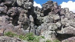
Basalt Bluff / Steve's Rock
Teton, Idaho
2.9 miles S of Teton, IdahoDon't go anywhere marked No Trespassing and Beware of the Attack Bees at the top of the cliffs and the Stinging Nettle at the bottom.
About a mile north of Loon Lake/Wentworth Springs Road junction, going towards Loon Lake, look up to the left to see this formation. Park on the road (narrow) and hike up to the the east face where all the climbs are. Can rappel off (2 ropes) or walk off to the north. Most routes are high quality with good rock. At last count there were 11 established routes here.
| Route | Difficulty | Ascents |
|---|---|---|
| 5.8 Hand Crack | 5.8 | 1 |
| Aoxomoxoa | 5.10b | 1 |
| Brown Shoes | 5.10c | 1 |
| Hangdogs Beget Eurodogs | 5.10a | 2 |
| Movin to Montana | 5.10c | 1 |
| Punk Titans Unchained | 5.10a | 1 |
| Three Ekka | 5.11a | 1 |
courtesy of RockClimbing.com
Twin Bridges
St. Anthony, Idaho
6.6 miles NE of St. Anthony, IdahoTwin Bridges is a beloved bridge-jumping and swimming spot on the river near St. Anthony, Idaho — a summer institution for families, teens, and college students across the upper Snake River Valley. The name comes from the setup: an old abandoned bridge stands right beside the one still in use, and the deep, slow water beneath the old span makes for about the best bridge jumping around, with no traffic to dodge and easy parking nearby.
The jumping is the main event, and it's well suited to a range of nerve. There are two distinct levels to leap from — a lower point around 11 feet and a higher one around 17 feet — so you can start small and work your way up, and the water below is plenty deep for cannonballs, flips, and gainers. Locals consider it about as good and as “reasonably safe” as bridge jumping gets, with one firm caveat: keep clear of the rocks along the sides, which can be exposed depending on the water level.
There's more to it than jumping. A little rope swing often hangs under the bridge — a favorite of the little kids — and a path up the river makes a good put-in for a short, mellow float back down. For families with young children, there's a sandbar on the north side just upstream of the action, perfect for wading and splashing away from the jumpers. The slow current is ideal for simply hanging out in the water while you watch your friends show off.
A fun local curiosity: downstream of the little rock dam on the north side lie the sunken remains of an old car, washed here after an accident years ago. When the water is low and clear you can spot its chrome bumper from the rocks and swim down for a look — a quirky bit of underwater sightseeing that regulars love.
Part of the appeal is how welcoming and community-minded the spot is. Generations of upper-valley families and Rexburg-area college students have made Twin Bridges their go-to summer swimming hole, and there's a friendly, everybody-shares-the-water vibe on a busy afternoon. It's the kind of simple, free, small-town summer pleasure that keeps people coming back week after week.
A few practical notes: it's a popular place, so expect a crowd on hot, sunny days and holidays — though it handles a lot of people well, and you rarely wait long to jump. Bring water shoes for the rocky spots, sun protection, and drinking water, always check the water depth and clear your landing before jumping (levels change through the season), keep an eye on kids near the current, and pack out all your trash. For a classic, easygoing eastern-Idaho swimming hole, Twin Bridges is hard to beat.
×


