


5 Bucket List by mckinley2018
first prev 1 2 next last
Fall Creek Falls
Swan Valley, Idaho
2.1 miles SW of Swan Valley, IdahoFalls Campground is located next to the Snake River near beautiful Swan Valley, only 45 miles east of Idaho Falls, Idaho. Mixed growth cottonwood trees provide partial shade, and grassy meadows with summer wildflowers dot the area. Wildlife is plentiful in the river bottom; eagles, osprey, moose, and deer are frequently spotted. Fall Creek Falls is about 1/4 mile from the campground. The Snake River offers excellent trout fishing, canoeing, rafting, and kayaking. Spring Creek and Conant Boat Ramps, open to the public, are nearby. Palisades Reservoir is less than 20 miles from Falls Campground, with great boating, waterskiing, canoeing, fishing, and swimming.

Mr. Bubbles Hot Spring
Old Faithful, Yellowstone National Park
24.0 miles SW of Old Faithful, Yellowstone National ParkMr. Bubbles is one of the few places you can actually soak in the thermal waters of Yellowstone National Park. The Bechler area of Yellowstone is one of the best kept secrets of the otherwise densely populated park. It's off the beaten path far from paved roads, boardwalks, tour busses and gift shops. In the backcountry, you'll walk singletrack dirt trails and see natural features not included on any brochure. There's also a good chance you'll see wildlife outside the safe comforts of your car door. Be aware of the animals around you (like bears, moose and bison). Give animals their space as to not threaten them.
You'll find the hot spring about halfway between the Bechler Ranger station and Old Faithful on the Bechler River Trail. (If you want to camp along the trail, you'll need to make a reservation with one of the parks backcountry offices)
This is a 15 mile hike to the attractions and another 15 to get out. Along the trail, you'll see several waterfalls and will have to cross the river multiple times. Some crossings are on logs while others are on bridges. Plan to get your feet wet. There is an impressive thermal feature near the hot springs.This is not the hot spring. This thermal feature is what pours into and heats up the small stream where you will soak in. Do not mistake this for the soaking pool you're looking for. The feature is dangerous because it will scald and can kill you. Mr. Bubbles will relax you. Don't mix them up!
CAUTION: WATER TEMPERATURES CHANGE AND ARE NOT ALWAYS SAFE. CHECK WITH THE RANGER STATION TO MAKE SURE IT'S SAFE BEFORE YOU PLAN YOUR TRIP.
CAUTION: NEVER HIKE AT NIGHT IN THE HOTSPOT AREAS OF YELLOWSTONE.. YOU WOULDN'T BE THE FIRST EXPERIENCED HIKER TO BE SCALDED TO DEATH IN AN UNEXPECTED THERMAL FEATURE.
Check https://www.nps.gov/yell/planyourvisit/swimming-soaking.htm for closures, regulations, and conditions.

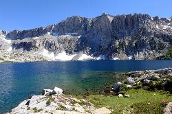
Packsaddle Lake
Tetonia, Idaho
9.3 miles W of Tetonia, IdahoPacksaddle is one of the less well known lakes/trails in the area. If you've got a good offroad vehicle, you can probably make it all the way to the end of the road, otherwise, it's just an extra 0.5 miles up the hill. Even to get to that point though, you may push the limits of your car or mini van and be required to do some pretty technical driving. There are plenty of good spots to park along the road if you decide that's as far as you can drive. The descent to the lake is pretty steep (300ft elevation drop) but less than a 1/2 mile to the lake. You'll be able to see the lake from the top of the trail. There's a little camp area on the eastern edge of the lake.
Mountain Bike Trail (From Lower Trailhead)
It starts on a slight incline and then gets gradually steeper. Trail is pretty smooth. After a tough climb, you get a downhill followed by a field. Then there's a fork in the road. If you actually want to get to the lake, take a left at the fork. Climb some more. View the beautiful Tetons on your left. You'll come to a clearing at the top. If you look down to the left, the lake is between the trees down the steep decline singletrack. Don't ride right into the lake. It's freezing, and does a quick dropoff. Courtesy of Singletracks.com

Bear Creek Hot Springs
Irwin, Idaho
9.8 miles S of Irwin, Idaho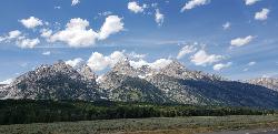
Grand Teton
Jackson Hole, Wyoming
17.6 miles N of Jackson Hole, WyomingAt 13,770 feet above sea level, the Grand Teton towers majestic over Southeastern Idaho and Western Wyoming, making it a life goal of many amateur climbers and outdoor enthusiasts.
The more popular routes all begin at the Lupine Meadows Trailhead and continue up through Garnet Canyon and The Meadows before splitting North. Most routes require rock climbing equipment and are only for skilled climbers. A guide is highly encouraged on any route. With 3k feet of exposure, falling from multiple segments of the trail would mean certain death.
Trailhead altitude: 6,732 ft
Summit altitude: 13,770 ft

Darby Wind Cave
Driggs, Idaho
7.6 miles E of Driggs, IdahoDarby Wind Cave is a beautiful hike full of waterfalls, wildflowers, streams, and mountainous views. The sites you see will depend on the time of year you visit but it will always be beautiful and just a little bit of a challenge.
The trail starts out relatively flat, following along close to where the old road used to run. There are a few creek crossings which will vary in difficulty depending on how much snow there was over the winter and how long it's been since things began to thaw. Late summer will usually find you crossing dry or nearly dry creek beds. If you hike when runoff is high, there are log bridges. You don't have to be highwire ready but one of the bridges will take a little bit of balance. The trail turns up South up into the canyon. About as soon as it starts to go up, you'll turn and begin a series of switchbacks (10 turns). These will take you up the East wall of the canyon.
The switchbacks are not incredibly steep but you'll gain elevation pretty quickly. After the switchback, the trail follows along a rim above the canyon where you can look across the canyon and see two beautiful waterfalls and mouth of the cave seemingly high overhead. At the South end of the canyon, you'll come across a rock overhang. It's fun at any time during the summer but earlier when the water is higher, you'll find a little waterfall and stream that the kids will love to play in and you'll be hard pressed not to soak your head and feet and cool off a bit yourself.
From the the overhang, the hike continues West along the South end of the canyon through some more forest and a beautiful meadow. Take a minute to look up from the trail to enjoy the view of Fossil Peak to the South. Just after the meadow, you'll begin another series of switchbacks up to the falls and cave. The first set (2 turns) will take you up to a dispersed campsite and monument. The next leg will take you to the creek where you can look up and get photos of the falls and cave. The next set puts you out just underneath a very large and beautiful waterfall that drops out over a ledge. The ledge itself is a popular repel accessible from above. You can walk all the way around these falls and even catch some spray on the downwind side. The next set of switchbacks are stairs cut out of the rock. Halfway will take you to an even better view of Fossil Peak and the remainder will take you to the mouth of the cave itself. To enter the cave, you'll have to cross one more creek which can be pretty scary and dangerous when the water is high. Entering the cave during high water can be just as scary.
Once you're in, the Wind Cave snakes through the Darby Formation, a thick layer of 350 million year-old dolomite. A flashlight for the cave is a definite must. Near the mouth, there's a series of ledges popular for bouldering. Just up about 100 yards, you'll come to a small hole you'll have to crouch to get through. You'll quickly realize why they're called the wind caves as you're blasted with wind from the caves coming out that hole. After about 200 yards, you'll want your climbing gear. The caves stretch for miles and if you go far enough, you'll enter the part known as the ice caves. Travel far enough, you'll come out the other side. Be careful though. The cave becomes pretty cavelike and it's really easy to get lost and, even in the busy season, it may be days until that nightmare ends with a rescue team.
The hike is about 3.1 miles from the South Fork Darby Canyon trailhead to the caves and is a 1,800 feet elevation gain. You'll find a lot of resources that claim the hike is a shorter distance. These sources either begin from the end of the old road or don't take into account one or both series of switchbacks. The cave itself sits at 8,940 feet above sea level.
Amphitheater Lake
Alta, Wyoming
12.6 miles E of Alta, Wyoming
Green Canyon
Smithfield, Utah
6.2 miles SE of Smithfield, UtahGreen Canyon is the most popular route up Mount Jardine. The elevation gain is gradual even though it is a long canyon. Its name originates from the healthy growth of green vegetation that is located in the canyon. The trail through the canyon is in good condtion to about 8,500 feet. Then is begins to fade away. At the junction that is located between Mount Elmer and Mount Jardine you will have to leave the trail and climb up the ridge between the two peaks.
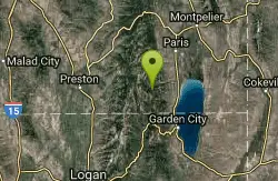
Bloomington Canyon Yurt
Bloomington, Idaho
1.6 miles W of Bloomington, IdahoBloomington Canyon Yurt in beautiful Bear Lake Idaho is offered by the WSU Outdoor Program. The yurt rental program is available to WSU students and the general public. Renting the yurt requires, route finding, experience in backcountry travel, and the ability to read a map and or GPS. The Bloomington Canyon Yurt opens up some of the best ski and snowmobile terrain Idaho has to offer.

Ghost Falls Trail
Sandy, Utah
5.0 miles S of Sandy, UtahGhost Falls is located in the corner canyon riding area of Draper, Utah and one of the first mountain bike routes in the canyon. It's a family-friendly hike, named for the trail's ability to disappear in winter seasons due to snow. The trail is mixed with a sandy rocky slope on the lower mountain and dirt higher up the mountain and the trail starts near trees along a dry creek bed, with views focused at Corner Canyon. After a few miles, the trail splits to the east along the old lower Corner Canyon road; this is where it can be confusing as there are several trails that split off the road. But, these diverging trails do continue to lead hikers east towards the upper canyon where the actual Ghost Falls trail north and south loops begin.
Most hikers stay on the road and then go off to the south along the Canyon Hollow Trail; which will lead to the intersection of the north/south Ghost Falls loop trail. There are signs that point which direction to go and which trail to stay on, so make sure to pay attention to the signs if you get lost. You can take different routes in order for the journey to be easier or a more challenging but fun opportunity to enjoy.

Bear Canyon Suspension Bridge
Draper, Utah
1.6 miles E of Draper, UtahThe Bear Canyon Suspension Bridge is a 185ft bridge that connects the Bear Canyon to the Bonneville Shoreline Trail. The bridge was built and completed in 2015 thanks to donations from residents and Ralph Wadsworth. It is about a 4.5 mile roundtrip trail, and is a moderate hike. The overall trail offers views of the Salt Lake Valley and is a very popular hike for families. There's a cage that stretches throughout the bridge so kids can run and play while being protected from falling off.
To get to the bridge, start on the Orson Smith trail; before you get on the trail, there are restrooms in case you want to go to the bathroom. There is a map on the trail continuing on the trail to the bridge so that you can stay on the path. During the trail, you'll be crossing the Aqueduct Trail and intersecting the Bonneville Shoreline Trail several times; follow the sign that says "bridge loop" but either direction will take you to the bridge. During the hike, you will see homes, go on steep climbs and eventually to the Bonneville Shoreline Trail, this is where you can take either way (the bonneville trail is flat and easier.) Continue on until you see the bridge.
Many people go on the trail for hiking or trail running. Besides the trail to the suspension bridge, there are many other trails that can be explored, taking hikers further up the mountain or to various other views of the valley.
The trail can be hiked in the winter, though it may have a lot of snow on the trail. Best times to hike are usually spring through fall.
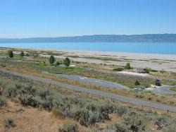
Rendezvous Beach
Laketown, Utah
2.2 miles NW of Laketown, UtahBear Lake State Park - Rendezvous Beach is located on the south shore near Laketown on State Route 30. Rendezvous Beach includes the Willow (3), Cottonwood (1), and Big Creek (1) group-use campsites, and the Cottonwood (32), Birch(60) and Big Creek (49) campgrounds. All campgrounds provide restrooms with flush toilets and hot showers. The Birch and Big Creek campgrounds offer the utility hookups of power, water, and sewer. A wide, long sandy beach makes this a popular place.

Cecret (Secret) Lake
Alta, Utah
1.5 miles SE of Alta, UtahCecret (pronounced "Secret") Lake is a beautiful lake located among alpine meadows in Little Cottonwood Canyons Albion Basin. Some folks spell Secret Lake as Cecret Lake, but the USGS maps list it as Secret Lake so I will stick with that. This is a hike that everyone can certainly enjoy since the route contains little difficulty and is very short.

Mill Creek Canyon
Salt Lake City, Utah
10.2 miles SE of Salt Lake City, UtahMill Creek is an out and back with over 1000 ft of elevation gain. The lower section of the ski trail gets a lot of foot traffic, but the upper section (above Elbow Fork) is generally very quiet. At the top of the canyon, there is a Yurt than can be reserved from December to April. Mill Creek Canyon is managed by the U.S. Forest Service.
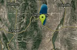
Bear Lake / North Beach
Saint Charles, Idaho
5.0 miles E of Saint Charles, IdahoBear Lake State Park is located in a high mountain valley in the extreme southeast corner of Idaho. At 5,900 feet elevation, the park offers a wide variety of both summer and winter recreation opportunities. Bear Lake itself is 20 miles long and 8 miles wide with half of the lake in Idaho and half in Utah. The lake is a water sports Mecca attracting boaters, water skiers, and beach lovers from all over the country. All that inviting water is hard to resist. Swimmers will enjoy a two-mile-long beach on the north end of the lake, plus a 1-1/2 mile beach on the east side. The gradual slope of the lake bottom provides an enormous swimming area. Ramps are available for boaters and water skiers who want to enjoy the water, too. Anglers can try for a native cutthroat or lake trout in the summer. In the winter, they can come back with buckets and nets when the Bonneville cisco run. The fish is found nowhere else on Earth.
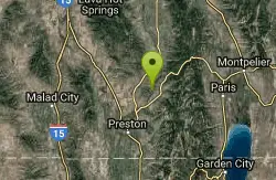
Oneida Narrows
Preston, Idaho
12.4 miles NE of Preston, IdahoBeautiful reservoir for fishing, boating, camping and family fun fishing for Smallmouth Bass, Walleye, and Yellow Perch.

Pineview Reservoir
Eden, Utah
0.8 miles SW of Eden, UtahLocated on the backside of the Wasatch Front, Pineview Reservoir in the Ogden River Canyon is home to stunning views of the water, sandy beaches, the Southern Skyline trail, paved ramps, and campgrounds thus providing a great location for recreational activities of many kinds. Popular activities include boating, canoeing, fishing, horseshoe, kayaking, paddle boarding, picnicking, swimming, volleyball, wakeboarding, and water skiing.
The reservoir is a vastly popular location for fishing tiger muskie and is great for experiencing the picturesque beauty of nature. The three swimming areas are Cemetery Point (west of Huntsville), Anderson Cove campground, and Middle Inlet Beach (north of Huntsville). Shade is scarce so be sure to bring your own canopy or cover during hot summer months as well as wear sun protection. The beaches tend to be busy on weekends.
The out-and-back Southern Skyline trail totals 18.2 miles in distance and is located between the highway and reservoir perfect for walking, biking, and riding dirt bikes. The trail initially commences with a slight uphill climb which increases as the trail progresses. Be cautious and courteous to wildlife including snakes. The campground gates are locked each night at 10 p.m. and are reserved on a first come, first served basis.
Minnetonka Cave
Saint Charles, Idaho
6.9 miles W of Saint Charles, IdahoMinnetonka Cave is the largest commercially developed limestone rock cave in the state of Idaho, and one of the highest, with an entrance elevation of 7,700 feet. The developed part of the cave contains nine separate "rooms" or chambers. The largest of these chambers is called the Ballroom, measuring more than 300 feet across and 90 feet high.

Donut Falls
Salt Lake City, Utah
14.9 miles SE of Salt Lake City, UtahVery popular beginning hike in the Salt Lake City area. Many take this as a good intro hike into the outdoors, while others go for a trip out with friends to escape the rush of daily life. The donut name comes from the waterfall that flows into a cave through a hole in the cave ceiling. If visitors want to get a good view of the waterfall they need to be prepared to get wet in the process.
Starting at a parking lot, visitors can follow a trail that will take them to a cave where, once they climb up and into it, will be greeted by the lovely Donut Falls. The climb into the cave is not too difficult. Visitors should just be careful of slick rocks from the stream as the climb into the cave of Donut Falls. Sometimes people want to climb on top of the cave roof and try to get a picture of the donut fall from the top down. This is not advised and trying to climb on the top has caused several fatalities in recent years.
Overall the hike is a great hike for families and friends. In the summers the parking lot and trail can get very crowded as everyone likes to visit this cave. If going, consider going in the morning and on a weekday, which will cut down on the amount of people on the trail. The trail is relatively short, about 3 miles round trip, though remember to bring water and a camera to capture the pleasant nature around you.
The forested trail is well marked. The trailhead is in Big Cottonwood Canyon near the Jordan Pines picnic area.

Adams Canyon Waterfall
Layton, Utah
3.2 miles E of Layton, UtahA great hike that is moderate in difficulty, but also provides a sense of adventure to hikers who love climbing rocks and seeing majestic waterfalls.


