


125 Things to do near Norris Geyser Basin, Wyoming 82190
first prev 1 2 3 4 5 6 7 next lastShowing results within 50 miles Distance miles of Norris Geyser Basin, Wyoming 82190, USA City, Zip, or Address
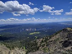
Dunraven Pass - Mount Washburn Trail
Canyon Village, Yellowstone National Park
12.9 miles EHikers looking for a scenic hike to the peak Mount Washburn will be pleased hiking the Mount Washburn Trail via Dunraven Pass. This trail winds through quiet forests to the peak. The trailhead for...
Hike 16.3 mi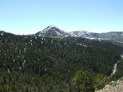
Mount Washburn Spur Trail
Canyon Village, Yellowstone National Park
14.1 miles EWashburn Spur Trail is an exciting 8-mile trail connecting the peak of Mount Washburn to Seven Mile Hole Trail near Canyon Village. Hikers typically hike the trail starting at Mount Washburn and...
Hike 4.4 mi
Chittenden Road - Mount Washburn Trail
Canyon Village, Yellowstone National Park
14.2 miles EHiking Mount Washburn via Chittenden Road is the shortest and easiest route to the top. The trail was once a service road and is now a clear well packed trail with a steady, gradual incline. The...
Hike 8.4 mi
Bunsen Peak Loop Bike Trail
Yellowstone National Park, Wyoming
14.3 miles NBunsen Peak Loop Bike Trail is a challenging trail that follows several service roads around Bunsen Peak. This 10 mile loop has a total elevation change of 1,120 feet, with several miles of the trail...
Mountain Bike 4.0 mi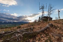
Bunsen Peak Trail
Mammoth Hot Springs, Yellowstone National Park
14.3 miles NBunsen Peak Trail is a 4.6 mile hike to the peak of Mount Bunsen. This is an out and back trail and is considered moderately difficult because of the 1,300 foot climb in elevation. ...
Hike 7.8 mi
Osprey Falls Trail
Mammoth Hot Springs, Yellowstone National Park
14.3 miles NOsprey Falls Trail is an 8 mile out and back trail near Mammoth Hot Springs that provides hikers with a variety of stunning views, including ravines and a waterfall. Hikers begin this hike...
Hike 2.8 mi
Mount Washburn Bike Trail
Devils Den, Wyoming
14.4 miles NEMount Washburn Bike Trail follows Chittenden Service Road for 2.5 miles to the top of Mount Washburn. This steep climb up the mountain provides a challenging elevation gain of 1500 feet. Mount...
Mountain Bike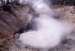
Mud Volcano
Lake Village, Yellowstone National Park
15.1 miles SEIn 1870 Mud Volcano had a cone-shaped mud deposit that covered the feature. By 1872 a thermal explosion had blown that mud away to reveal what we see today.
Hike 0.7 mi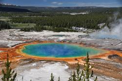
Grand Prismatic Spring
Old Faithful, Yellowstone National Park
15.1 miles SWThe Grand Prismatic Spring in Yellowstone National Park is the largest hot spring in the United States, and the third largest in the world, after Frying Pan Lake in New Zealand and Boiling Lake...
Hike 0.8 mi
Wraith Falls Trail
Mammoth Hot Springs, Yellowstone National Park
15.4 miles NWraith Falls Trail is a less than 1 mile there and back hike that can be taken in under an hour. This is a wonderful family friendly hike that is easy for hikers of all levels. The hike leads...
Hike 0.3-5.0 mi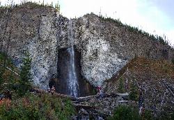
Fairy Falls
Old Faithful, Yellowstone National Park
15.9 miles SWFairy Falls is something out of a fantasy novel. Fairy Falls is a wonderful portion of Yellowstone. It has stolen the hearts of many who have had a little pixie dust sprinkled on them...
Hike 2.0 mi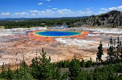
Grand Prismatic Spring Overlook Trail
Old Faithful, Yellowstone National Park
15.9 miles SWThe Grand Prismatic Spring Overlook Trail gives hikers an opportunity to see the famous aerial view of the Grand Prismatic Spring. The vibrant rainbow waters of the Grand Prismatic Spring are...
Hike 2.0 mi
Snow Pass Trail
Yellowstone National Park Wyoming
16.1 miles NSnow Pass Trail is a beautiful day hike for visitors to Yellowstone looking to escape the crowds. Located a half mile south of the Mammoth Hot Springs Upper Terraces. Parking is available at a...
Backpack, Hike 7.4 mi
Blacktail Deer Creek to Yellowstone River Trail
Mammoth Hot Springs, Yellowstone National Park
16.8 miles NBlacktail Deer Creek Trail is a 7 mile out and back trail that leads to the Yellowstone River. Hikers on this trail will enjoy seeing green open fields, boulder formations and waterfalls at the...
Hike 5.3 mi
Beaver Ponds Trail
Mammoth, Yellowstone National Park
17.1 miles NBeaver Ponds Trail is a wonderful short hike accessible from Mammoth Hot Springs. The trail forms a loop between the two trailheads available at Mammoth Hot Springs. The loop is just over 5 miles...
Hike 8.1 mi
Sepulcher Mountain Trail
Mammoth Hot Springs, Yellowstone National Park
17.1 miles NSepulcher Mountain Trail is an 11 mile loop trail from Mammoth Hot Springs to the peak of Sepulcher Mountain. This is a challenging hike with a 3,500 foot ascent to the 9,652 foot peak. The...
Hike 0.1-5.2 mi
Mammoth Hot Springs
Mammoth, Yellowstone National Park
17.1 miles NMammoth Hot Springs is a unique sight in Yellowstone National Park. The soft limestone in this area allowed the water to form colorful terraces. The extremely hot running water is clear and smooth,...
Camp, Hike 4.0 mi

Lava Creek Trail
Mammoth Hot Springs, Yellowstone National Park
17.2 miles NLava Creek Trail is a 4.2 mile hike where hikers can enjoy walking along the scenic Lava Creek. The trail passes Undine Falls and the Gardner River. Undine Falls is a beautiful 60 foot...
Hike
Mammoth Hot Springs Campground
Mammoth Hot Springs, Yellowstone National Park
17.3 miles NMammoth Hot Springs Campground is the only campground in Yellowstone that is open to campers year-round. Campsites cannot be reserved and are available on a first come first served basis. It is...
Camp
Mammoth/Gardiner Back Road
Mammoth Hot Springs, Yellowstone National Park
17.4 miles NThe only road open in Yellowstone National Park is Highway 89 at Gardiner, Montana to park Headquarters at Mammoth Hot Springs and from Mammoth Hot Springs to Silver Gate and Cooke City, Montana.
Hike, Mountain Bike


