


32 Hiking Trails near Asheville, NC
first prev 1 2 next lastShowing Hiking Trails within 50 miles Distance miles of Asheville, NC, USA City, Zip, or Address

Richmond Hill
Asheville, North Carolina
2.7 miles NWHilly, wooded course. Handmade signs and Astro Turf tees. Alt. pins on 14 holes. Long pants smart (poison ivy). Parking lot OB. Public (No Fee) Richmond Hill Park is Asheville's largest wooded...
Disc Golf, Hike, Mountain Bike
Bent Creek
Asheville, North Carolina
8.0 miles SWBent Creek is the go-to trail system for the greater Asheville area, and with the deeply-ingrained mountain bike culture in the Asheville/Brevard area, and Western North Carolina in general, Bent...
Hike, Mountain Bike
Hardtimes Connector / 661
Asheville, North Carolina
8.4 miles SWThis trail connects to the main trail system and the big climbs to the top from the Hardtimes Trailhead. This section of singletrack lies in the flatter terrain but leads to the big climbs up the...
Hike, Horseback, Mountain Bike
Little Hickory Top
Asheville, North Carolina
8.4 miles SWDogs: Leashed
Hike, Horseback, Mountain Bike 3.4 mi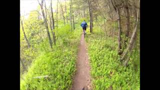
Alexander Mountain Bike Park
Alexander, North Carolina
9.7 miles NWNice, challenging singletrack. Not overly technical, with some nice climbs and nice flowing sections, and a nice view of the French Broad river. However, this trail does get overgrown sometimes from...
Hike, Horseback, Mountain Bike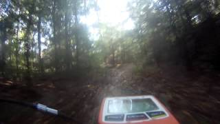
South Mills River Trail
Canton, North Carolina
18.3 miles SWThis is an easy out-and-back trail that follows the South Fork Mills River with several swinging bridge crossings that leads to the site of the old Cantrell Lodge. From the trail head, the left side...
Hike, Mountain Bike 0.8 mi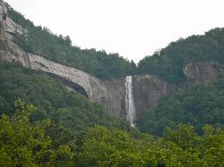
Hickory Nut Falls
Chimney Rock, North Carolina
20.1 miles SEChimney Rock Park is a privately operated park within Chimney Rock State Park - there is an admission fee -... Fees: Yes, see web site
Hike, Swim
Pilot Cove Loop Trail
Pisgah Forest, North Carolina
21.1 miles SWThis short 1.8-mile trail has some steep, very tight singletrack and some very tight turns... but it is well-worth riding because it houses one of the best views in Pisgah National Forest! Definitely...
Hike, Mountain Bike
Big East Fork
Canton, North Carolina
21.9 miles SWBig East Fork is a trail along Pigeon River with a variety of activities available. This trail travels through heavy forest along the river with beautiful, clear water. There are several waterfalls...
Backpack, Hike, Kayak, Swim
North Slope
Pisgah Forest, North Carolina
23.6 miles SWThis trail is only open from October 15 - April 15. This trail is very worn and is more suitable to hiking, but it is an interesting bike trail nonetheless. Start from the parking lot and ride across...
Hike, Mountain Bike
Davidson River Campground
Pisgah Forest, North Carolina
23.7 miles SWDavidson River Recreation Area offers camping and outdoor activities for the whole family. The campground boasts several loops of shaded campsites, as well as access to hiking trails, fishing spots,...
Camp, Hike, Swim
Thrift Cove
Brevard, North Carolina
23.8 miles SWStart riding the trail at the back of the parking lot. Go about 0.1 miles and turn right up Thrift Cove trail. Follow the red blazes and turn left at the intersection with Grass Road. On the way back...
Hike, Mountain Bike
Avery Creek / 327
Brevard, North Carolina
23.8 miles SWThe bottom end of Avery Creek can be accessed via FS 477, and the top can be accessed via the Buckwheat Knob trail, the Black Mountain trail, or the Club Gap trail. Avery Creek descends for 3.2 miles...
Hike, Mountain Bike
Bennett Gap / 138
Pisgah Forest, North Carolina
23.8 miles SThis trail is 3 miles in one direction. Again, another gnarly Pisgah-area trail! This trail has several awesome views off the top of the ridge of Looking Glass mountain. Absolutely incredible--be...
Hike, Mountain Bike

Looking Glass Falls
Brevard, North Carolina
24.0 miles SWLooking Glass Falls is a gorgeous and easily accessible waterfall in Brevard, North Carolina. This waterfall is a short and beautiful walk from Pigsah Highway (Highway 276). Parking is available just...
Hike, Swim
Coontree Recreation Area
Brevard, North Carolina
24.3 miles SWCoontree Recreation Area is a beautiful area with many amenities and activities on the Davidson River. This recreation area is best known for its picnic area with a beautiful view of the river. The...
Hike, Mountain Bike, Swim
Big Laurel Creek Area
Marshall, North Carolina
24.4 miles NWAn easy, family-type, hike to several swimming holes of various degrees of challenge in Big Laurel Creek on its way to join the French Broad River. For details... Bathing suits: May be optional at...
Hike, Kayak, Swim, Whitewater
Skinny Dip Falls
Brevard, North Carolina
24.7 miles SWSkinny Dip Falls is a beautiful and family friendly waterfall. Despite the misleading name, bathing suits are not optional at Skinny Dip Falls. Skinny Dip Falls is a long, thin cascading waterfall...
Hike, Swim
Rocky Bluff
Hot Springs, North Carolina
24.8 miles NWPlay in water in creek, shallow at times.
Camp, Hike, Swim 0.2-2.8 mi
Graveyard Fields
Brevard, North Carolina
25.3 miles SWGraveyard Fields is a beautiful hike known for it's forests, wild flowers and two beautiful waterfalls. The Blue Ridge Mountains surround this area creating stunning views throughout the...
Hike, Swim


