


Lake Russell Recreation Area
Mt Airy

Camp, Canoe, Hike, Kayak, and Swim
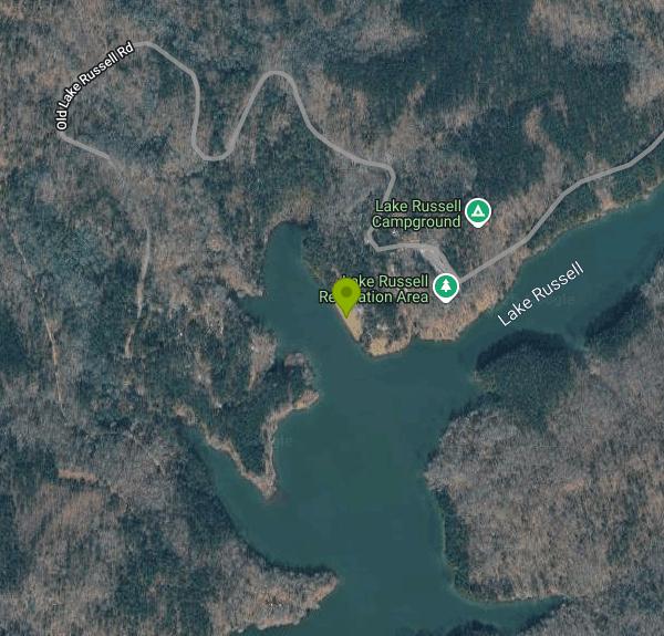
Lake Russell Recreation Area is a U.S. Forest Service day-use and camping area on Lake Russell, a 100-acre reservoir in the Chattooga River Ranger District of the Chattahoochee-Oconee National Forest. It sits in Habersham County a couple of miles south of Mt. Airy and about 12 miles from Cornelia, surrounded by the hardwood and pine ridges of the Lake Russell Wildlife Management Area. The Forest Service runs the swim beach and boat launch as one fee site, called the Lake Russell Boat Launch and Beach Areas, next to the 42-site Lake Russell Campground.
From US 441/23, take the Old Hwy 197 exit at Mt. Airy and follow Old Hwy 197 about 3.2 miles to the stop sign at Dicks Hill Parkway. Turn right, cross the bridge, then turn left onto paved Lake Russell Road and follow it about 4 miles to the recreation area entrance on the left. The fee tube is on the right just past the bridge. The Forest Service lists the physical address as 3034 Lake Russell Road, Mt. Airy. Parking at the adjoining Nancytown Day Use area is included for Lake Russell day visitors.
The swim beach is a grassy lawn rather than sand, on a point along the lake's north side near the boat ramp parking loop, with a designated swimming area marked off the bank and picnic tables and grills close by. The water is not shallow everywhere inside that boundary. A 12-year-old drowned here in June 2023 and was found in about 10 feet of water inside the designated swimming area, so weak swimmers and children need close supervision. The Forest Service does not list lifeguards, so plan on swimming at your own risk. Dogs are not allowed on the beach, and shore fishing is not allowed inside the swim area boundary. Gas motors are banned on the lake, so the only boat traffic is paddlers and electric trolling motors.
Day use costs $5 per non-commercial vehicle per day, a federal standard amenity fee. The Forest Service's current page no longer prints the amount and simply links to the Recreation.gov pass, but its listing earlier in 2026 gave $5 per vehicle for both the picnic and swim site and the boat launch. Pay ahead on Recreation.gov or scan the QR code at the kiosk with the Recreation.gov app (cell service is spotty, so download the app first), then display the confirmation on your dashboard. America the Beautiful passes are accepted. The boat ramp is open year-round, but beach facilities only operate during the summer season, and the day-use areas are closed from sunset to sunrise. The Forest Service lists no potable water at the day-use site, so bring your own.
The Lake Russell Loop Trail (FS Trail 73) circles the lake, and the Sourwood and Rhododendron trails connect to the smaller Nancytown Lake, which Georgia DNR stocks with trout, and to the Chenocetah Fire Tower on the ridge above. The Lady Slipper trail system nearby is open to hikers, mountain bikers and horseback riders. Campsites at Lake Russell Campground are reservation only through Recreation.gov. The surrounding WMA holds managed deer and turkey hunts; hunters must stay 150 yards from developed recreation sites, though forest road traffic picks up during hunt dates. The district office in Lakemont can be reached at 706-754-6221.
More Information
12-year-old dead after drowning at Lake Russell, officials investigating
At this time, the identity of the juvenile is not being released.
https://www.yahoo.com/news/juvenile-dead-drowning-lake-russell-234404955.htmlChattahoochee-Oconee National Forest | Chattooga River District | Forest Service
The Chattooga River Ranger District covers 261,035 acres in the northeast part of Georgia. Terrain ranges from the Piedmont in the southern part of the district to Georgia's second highest mountain, Rabun Bald at 4,696 feet above sea level. To the east is the Chattooga Wild and Scenic River. In the central part of the district are Lake Burton, Seed Lake, and Lake Rabun where you'll find the Rabun Beach Campground. In the western part of the district are the headwaters of the Chattahoochee River and the Upper Chattahoochee River Campground. The Appalachian National Scenic Trail passes through the district. There are many waterfalls across the district including the twin waterfalls of Anna Ruby Falls Scenic Area. Contact the district office for more information.Chattooga River Ranger District Map (46.1 MB PDF)Counties Covered: Banks, Habersham, Rabun, Stephens, Towns, WhiteWildlife Management Areas: Swallow Creek WMA, Warwoman WMA, Lake Russell WMA, Chattahoochee WMA, Chestatee WMA Chattooga River Ranger District Recreation Sites:Andrews Cove Campground – White CountyAngel Falls Trailhead – Rabun CountyAnna Ruby Falls Recreation Area – White CountyBartram Trail – Rabun CountyBroad River Trail – Stephens CountyChattooga River Trail – Rabun CountyDarnell Shooting Range – Habersham CountyDukes Creek Falls Recreation Area – White CountyFern Springs Recreation Area – Habersham CountyFrady Branch Equestrian and Bike Trail System – Habersham CountyHemlock Falls Hiking Trailhead – Rabun CountyLake Rabun Beach Recreation Area – Rabun CountyLake Rabun Campground – Rabun CountyLake Russell Boat Launch and Beach Areas – Habersham CountyLake Russell Recreation Area Campground – Habersham CountyLocust Stake OHV Trail System – Habersham CountyLow Gap Campground – White CountyMount Yonah Trailhead – White CountyNancytown Day Use Area – Habersham CountyOakey Mountain OHV Trails – Habersham CountyPanther Creek Recreation Area – Habersham CountyPear Tree Hill Group Camp – Rabun CountyRavens Cliff Trailhead – White CountyRussell-Brasstown National Scenic Byway – White, Union, Towns CountiesSandy Bottoms Campground – Rabun CountySarah's Creek Campground – Rabun CountyStonewall Falls & White Twister Mountain Bike Trail – Rabun CountyTallulah River Campground – Rabun CountyTate Branch Campground – Rabun CountyUpper Chattahoochee River Campground – White County
https://www.fs.usda.gov/r08/chattahoochee-oconee/recreation/chattooga-river-districtChattahoochee-Oconee National Forest | Lake Russell Boat Launch and Beach Areas | Forest Service
Adjacent to the nearby Lake Russell Campground the 100-acre lake is easy to access grass beach area, boat ramp, group pavilion, and the adjacent Lake Russell Wildlife management area. There are numerous hiking and biking trails including Lake Russell Loop Trail, Sourwood Trail, swimming, and located nearby is Ladyslipper Equestrian, hiking, and biking trail and the Sourwood hiking and biking trail at the Nancytown Day Use and Trailhead.Fishing, boating, kayaking, and paddle boarding opportunities abound. Trolling motor and non-motorized boating only allowed on Lake Russell. This bucolic getaway is sure to become an outdoor destination for the entire family!
https://www.fs.usda.gov/r08/chattahoochee-oconee/recreation/lake-russell-boat-launch-and-beach-areasChattahoochee-Oconee National Forest | Lake Russell Recreation Area Campground | Forest Service
Lake Russell Campground is currently open and ready for you to reserve a site on your next visit to this beautiful campground. Camping is by reservation only. This developed campground offers 42 campsites that accommodate both tent and RV camping distributed along two paved campground loop roads for easy access to the Lake Russell Recreation Area. Loop A16 camping sites1 Conventional flush restroom.Standard amenities (i.e. fire rings, picnic tables, lantern posts, etc)Easy access to the Lake Russell Wildlife Management Area on the trail system that goes around the lakeDump Station located just outside Loop A.Loop B 26 camping sites.2 Conventional flush restrooms, all with hot showersStandard amenities (i.e. grill, picnic tables, lantern post, etc).Easy access to the Lake Russell Wildlife Management Area on the trail system that goes around the lakeRV CampingA dump station is located near the entrance to Loop A.No electricity at the sites. Water at spigots within the loopThe length of stay is 14 days.
https://www.fs.usda.gov/r08/chattahoochee-oconee/recreation/lake-russell-recreation-area-campgroundChattahoochee-Oconee National Forest | Nancytown Day Use | Forest Service
Nancytown Day Use is a great spot for families and offers access to many activities such as fishing, hiking, horseback riding, bicycling and picnicking. This site is easily accessible by vehicle to the small parking lot above the Nancytown dam and simple walk down to your new favorite fishing site or continue onto the Lake Russell Loop trail that leads to the Lake Russell Campground. The Lake Russell Boat Launch/Beach Areas are only a half a mile down the road.Going from the picnic area travel across either bridge and it will take you to one of the two historic Civilian Conservation Corps picnic shelters along the lake or go to the 6.2-mile Ladyslipper trail (horseback riding, hiking, and biking) tor the Sourwood (hiking, biking), which is a 2.7-mile hike to several waterfalls.This area has multiple opportunities for anglers and is a great place to catch trout. Non-motorized boats are allowed in Nancytown Lake.
https://www.fs.usda.gov/r08/chattahoochee-oconee/recreation/nancytown-day-useChattahoochee-Oconee National Forest | Passes | Forest Service
When you are ready to recreate on your national forests and grasslands, determine if your plans require a recreation fee and what types of passes are available. Many recreation sites and activities on the Chattahoochee-Oconee National Forests do not require a fee at all. No matter where you are going on federal public lands, take advantage of the type of pass that will work best for you.
https://www.fs.usda.gov/r08/chattahoochee-oconee/passesLake Russell Boat Launch and Beach Areas Pass in Georgia - Recreation.gov
Buy Lake Russell Boat Launch and Beach Areas Activity Pass in Chattahoochee-Oconee National Forest, Georgia with Recreation.gov. Adjacent to the nearby Lake Russell Campground is easy to access grass beach area, boat ramp, group pavillon, and the adjacent Lake Russell Wildlife management
https://www.recreation.gov/activitypass/AP21154Lake Russell Recreation Area, Chattahoochee-Oconee National Forest - Recreation.gov
Explore Lake Russell Recreation Area in Chattahoochee-Oconee National Forest, Georgia with Recreation.gov. This North Georgia mountain mecca has something for everyone, swimming, camping, picnicking, hiking, biking (on and off road), fishing and boating (electric, wi
https://www.recreation.gov/camping/campgrounds/273781Lake Russell WMA | Department Of Natural Resources Division
Lake Russell Wildlife Management Area is located in Cornelia on property owned by the U.S. Forest Service. This 17,300-acre property has opportunities for deer, bear, turkey, small game and coyote hunting.Vehicle Usage: ATVs and UTVs are not allowed on U.S. Forest Service roads. They may only be used on roads/trails designated specifically for their use. For more information, visit https://www.fs.usda.gov/detail/conf/home/?cid=fseprd1154774.
https://georgiawildlife.com/lake-russell-wmaBe courteous, informed, and prepared. Read trailhead guidelines, stay on the trail, and don't feed the wildlife.
Read More
- Plan Ahead and Prepare
- Travel & camp on durable surfaces
- Dispose of waste properly
- Leave what you find
- Minimize campfire impacts
- Respect wildlife
- Be considerate of other visitors
Directions
From Mt Airy
- Head southwest on E Pine St toward S Main StPass by O'Reilly Auto Parts (on the right in 1.5 mi)(7.2 mi)
- Turn left onto the I-74 W/
I-77 N ramp (0.2 mi) - Merge onto I-74 W (0.5 mi)
- Take exit 5 on the left to merge onto I-77 S toward Statesville/
Charlotte (68.8 mi) - Keep right to stay on I-77 S (3.6 mi)
- Keep right to stay on I-77 S (1.3 mi)
- Keep right to stay on I-77 S (7.1 mi)
- Take exit 19B-A toward I-85 S/
Pineville (1.1 mi) - Merge onto I-485 Outer (10.4 mi)
- Take the exit onto I-85 S toward SpartanburgPassing through South CarolinaEntering Georgia(144 mi)
- Take exit 173 for GA-17 toward Lavonia/
Toccoa/ Elberton (0.2 mi) - Take the ramp to Tugaloo State Pk (125 ft)
- Turn left onto GA-17 NPass by Pizza Hut (on the left)(12.8 mi)
- Turn left to stay on GA-17 N (9.8 mi)
- Turn left onto Rock Rd (0.8 mi)
- Turn right onto Dicks Hill Pkwy (7.1 mi)
- Turn left onto Grandview Ave (141 ft)
- Continue straight onto Lake Russell Rd (2.0 mi)
- Continue straight (0.7 mi)
- Continue onto Old Lake Russell Rd (0.1 mi)


Other Swimming Holes, Hiking Trails, Canoeing Areas, and Kayaking Areas Nearby

Tallulah Falls Lake Beach (Terrora Day Use Area)
Tallulah Falls, Georgia
17.9 miles NSand swim beach on 63-acre Tallulah Falls Lake at Tallulah Gorge State Park's Terrora Day Use Area, with the gorge rim trails, suspension bridge and campground next door.
Camp, Hike, Kayak, Mountain Bike, Swim
Lake Rabun Beach Recreation Area
Lakemont
18.1 miles NA small Forest Service swim beach with a roped swim area on Lake Rabun near Lakemont, Georgia. Open sunrise to sundown year-round; day use is $5 per person age 16 and up.
Camp, Hike, Kayak, Swim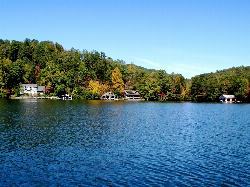
Timpson Cove Beach
Clayton
24.9 miles NA Georgia Power swim beach on the east shore of Lake Burton, with a buoyed swim area, picnic tables and restrooms about nine miles out of Clayton. No posted fee, no lifeguard, and a winter drawdown that decides how much sand there is.
Swim
Bolding Mill Park
Gainesville
27.9 miles WA Corps of Engineers park on Lake Lanier's Chestatee arm near Gainesville with a designated swim beach built on a gentle concrete slope, plus shelters, a boat ramp and a campground. Corps day-use fee applies.
Camp, Kayak, Swim
War Woman Dell Wildlife Management Area
Clayton, Georgia
28.2 miles NA short 0.8-mile out-and-back hike near Clayton, Georgia through a nature trail to a waterfall — good for all skill levels and accessible year-round.
Camp, Hike, Horseback
Vogle State Park
Blairsville, Georgia
30.6 miles NWA 233-acre park at the base of Blood Mountain in the Chattahoochee National Forest — one of Georgia's first state parks, founded in 1931.
Camp, Canoe, Swim
Van Pugh North Park
Flowery Branch
34.7 miles SWCorps of Engineers day-use park on Lake Lanier near Flowery Branch with a designated swim beach at the end of the park road. $8 per vehicle, card only, no lifeguards, no pets.
Kayak, Swim
Boone Area
Otto, North Carolina
37.0 miles NSwim near Otto, North Carolina
Swim
Big Laurel Falls
Otto, North Carolina
37.0 miles NSwim near Otto, North Carolina
Swim
Elrod Ferry Recreation Area
Hartwell
37.8 miles ECorps of Engineers day-use park on a wooded point of Hartwell Lake near Hartwell, Georgia, with three designated swim beaches, picnic shelters and a boat ramp. $7 per vehicle.
Swim
Chattahoochee National Park
Cave Spring, Georgia
39.2 miles NWSwim near Cave Spring, Georgia
Swim
Lanier Park
Buford
39.6 miles SWA Corps of Engineers day-use park just north of Buford Dam with a small swim beach in a sheltered cove of Lake Lanier. $8 per vehicle or $3 on foot, open 8 a.m. to 10 p.m., no lifeguards.
Hike, Kayak, Swim
Buford Dam Park Beach (Lake Lanier)
Buford, Georgia
39.7 miles SWSmall sandy swim beach in a no-boat cove at the Corps of Engineers' Buford Dam Park on Lake Lanier, with shelters, a fishing pier and the Laurel Ridge Trail.
Hike, Kayak, Swim
Watson Mill Bridge State Park
Comer, Georgia
40.4 miles SESwim near Comer, Georgia
Swim 2.4 mi
Edge Of The World
Dawsonville, Georgia
41.0 miles WA scenic 3-mile hike along the Amicalola River to a family-friendly swimming hole and small waterfall near Atlanta.
Hike, Swim
Todd Creek Falls
Central, South Carolina
42.7 miles NEA short hike leads to Todd Creek Falls and a deep, gradually entered pool at the base — a relaxed clothing-optional spot in the South Carolina upstate woods.
Swim
Pooles Mill
Ball Ground, Georgia
44.7 miles WSwim near Ball Ground, Georgia
Swim
Cashiers Area
Woodleaf, North Carolina
45.9 miles NESwim near Woodleaf, North Carolina
Swim
Fires Creek Area
Wake Forest, North Carolina
46.5 miles NWSwim near Wake Forest, North Carolina
SwimNearby Campsites
Tallulah Falls Lake Beach (Terrora Day Use Area)
Tallulah Falls, Georgia
17.9 miles NSand swim beach on 63-acre Tallulah Falls Lake at Tallulah Gorge State Park's Terrora Day Use Area, with the gorge rim trails, suspension bridge and campground next door.
Camp, Hike, Kayak, Mountain Bike, Swim
Lake Rabun Beach Recreation Area
Lakemont
18.1 miles NA small Forest Service swim beach with a roped swim area on Lake Rabun near Lakemont, Georgia. Open sunrise to sundown year-round; day use is $5 per person age 16 and up.
Camp, Hike, Kayak, Swim
Bolding Mill Park
Gainesville
27.9 miles WA Corps of Engineers park on Lake Lanier's Chestatee arm near Gainesville with a designated swim beach built on a gentle concrete slope, plus shelters, a boat ramp and a campground. Corps day-use fee applies.
Camp, Kayak, Swim
War Woman Dell Wildlife Management Area
Clayton, Georgia
28.2 miles NA short 0.8-mile out-and-back hike near Clayton, Georgia through a nature trail to a waterfall — good for all skill levels and accessible year-round.
Camp, Hike, Horseback
Vogle State Park
Blairsville, Georgia
30.6 miles NWA 233-acre park at the base of Blood Mountain in the Chattahoochee National Forest — one of Georgia's first state parks, founded in 1931.
Camp, Canoe, Swim


