


Edge Of The World
Dawsonville, Georgia
| GPS: |
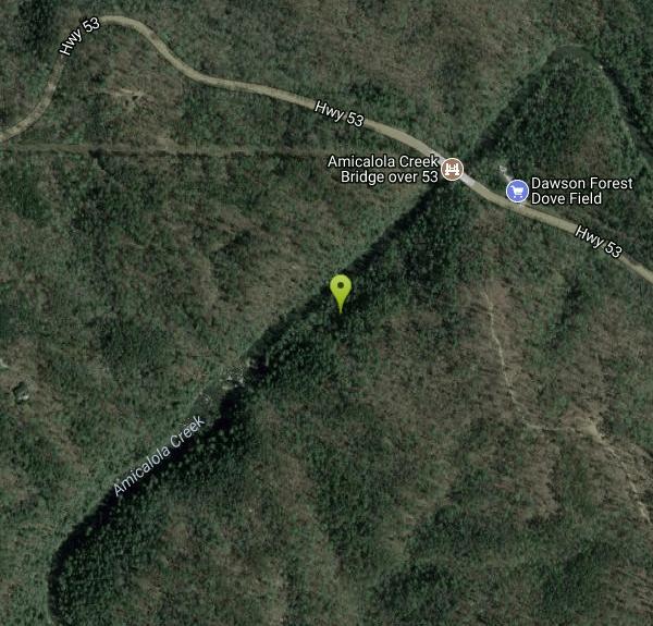
34°25'34.3"N 84°12'41.3"W Maps | Directions |
| State: | Georgia |
| Trail Length: | 3.00 miles |
| Trail Type: | Out & Back |
| Hike Difficulty: | Beginner |
| Trails/Routes: | 2.4 mi |
Hike and Swim
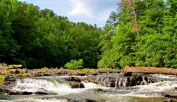
Edge of the World — known to locals as the Amicalola River Rapids — is one of the most popular natural swimming holes in the greater Atlanta area, drawing visitors from across the region to a scenic stretch of the Amicalola River near Dawsonville, Georgia. Here the river tumbles over a series of rocky ledges and small rapids into clear pools, framed by one of the prettiest hardwood-forest canyons in the North Georgia mountains. On a hot Georgia day, the cool, rushing water and the broad sunning rocks make it a beloved spot for families, swimmers, and picnickers.
The rapids sit within Dawson Forest Wildlife Management Area, and reaching them is part of the fun. A short, ADA-accessible boardwalk trail (about half a mile one way) leads from the parking area down to viewing platforms above the water, while a longer 2.5-mile loop trail winds through the woods and along the Amicalola for those who want a proper walk. Ambitious hikers can continue upstream in search of additional cascades, and you'll pass plenty of rocky picnic and lounging spots right beside the river along the way.
Important access note: because this is a state Wildlife Management Area, the Georgia Department of Natural Resources requires that everyone age 16 and older carry a valid Georgia Lands Pass, hunting license, or fishing license to enter — and wardens do check and issue fines. Passes are inexpensive and can be purchased online at gooutdoorsgeorgia.com or by phone. The DNR also closes the WMA for scheduled hunts — for example, keeping the area closed until 10 a.m. during spring turkey season and shutting it entirely on certain hunt dates — so it's worth checking the Dawson Forest WMA calendar before you go.
The Amicalola along this stretch is also a well-known whitewater run, and on higher water you may spot kayakers bouncing through its Class II–III rapids. The area pairs naturally with nearby Amicalola Falls State Park — home to the tallest cascading waterfall east of the Mississippi and only a short drive away — an easy way to round out a day in this scenic pocket of Dawson County.
A word on safety: this is moving water, not a placid pond. The rapids and rocks are slippery, the current can be strong, and the river rises quickly after rain — conditions that have caught swimmers off guard. Keep a close eye on children, scout the depth and current before you jump, and stay clear of the strongest flow, especially when the water is high or fast.
Come prepared with water shoes for the slick rock, plenty of drinking water, and sun protection, and pack out everything you bring to help keep this well-loved spot beautiful. Spring through early fall is prime swimming season, with summer weekends the busiest. With your lands pass in hand and a little caution around the water, Edge of the World lives up to its name — a refreshing, scenic escape in one of the loveliest corners of North Georgia.
More Information
Dawson Forest WMA | Department Of Natural Resources Division
Updated 2/5/26City of Atlanta Tract: A few roads may be closed to ongoing Winter Storm cleanup. Please check with the Gainesville office (770-535-5700) for updates.
https://georgiawildlife.com/dawson-forest-wmaBe courteous, informed, and prepared. Read trailhead guidelines, stay on the trail, and don't feed the wildlife.
Read More
- Plan Ahead and Prepare
- Travel & camp on durable surfaces
- Dispose of waste properly
- Leave what you find
- Minimize campfire impacts
- Respect wildlife
- Be considerate of other visitors
Directions
From Dawsonville, Georgia
- Head east toward GA-9 S (358 ft)
- Exit the traffic circle onto Main St (0.3 mi)
- Continue onto GA-53 W/
Jasper St (2.3 mi) - At the traffic circle, take the 2nd exit onto GA-53 (3.7 mi)



Other Swimming Holes and Hiking Trails Nearby
Pooles Mill
Ball Ground, Georgia
9.5 miles SSwim near Ball Ground, Georgia
Swim
Buford Dam Park Beach (Lake Lanier)
Buford, Georgia
20.4 miles SESmall sandy swim beach in a no-boat cove at the Corps of Engineers' Buford Dam Park on Lake Lanier, with shelters, a fishing pier and the Laurel Ridge Trail.
Hike, Kayak, Swim
Chattahoochee National Park
Cave Spring, Georgia
24.9 miles NSwim near Cave Spring, Georgia
Swim
Mill Creek
Woodstock, Georgia
26.7 miles SWSwim near Woodstock, Georgia
Swim
Vogle State Park
Blairsville, Georgia
28.8 miles NEA 233-acre park at the base of Blood Mountain in the Chattahoochee National Forest — one of Georgia's first state parks, founded in 1931.
Camp, Canoe, Swim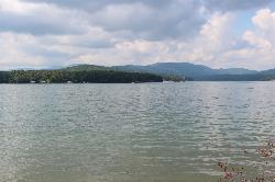
Morganton Point Recreation Area
Morganton, Georgia
30.7 miles NForest Service swim beach, campground and boat ramp on a wooded point jutting into Lake Blue Ridge, two miles from the town of Morganton.
Camp, Canoe, Hike, Kayak, Swim 5.6 mi
Emery Creek Trail
Chatsworth, Georgia
36.5 miles NWTwo beautiful waterfalls and a small swimming hole shine on this 5.9-mile Northern Georgia trail, but plan for multiple creek crossings — water shoes are a must.
Hike 0.8 mi
Holly Creek Picnic Area
Chatsworth, Georgia
36.8 miles NWA scenic North Georgia picnic and swimming spot with a shallow creek hole, easy rock jumps, and kayaking nearby.
Canoe, Kayak, Swim
Diving Rock
Atlanta, Georgia
39.3 miles SA 25-foot granite diving rock, a riverside beach, and cool, clear water on the Chattahoochee — a classic Atlanta swimming hole.
Swim
Yellow River Park
Stone Mountain, Georgia
44.8 miles SSwim near Stone Mountain, Georgia
Swim
Conasauga Area
Soddy-Daisy, Tennessee
46.2 miles NWSwim near Soddy-Daisy, Tennessee
Swim
Blue Hole Ocoee
Turtletown, Tennessee
46.4 miles NNumerous swimming holes 10-to-15 feet deep with tunnels to swim through, cliff jumping, and snorkeling in crystal-clear water — a great family adventure on the Ocoee.
SwimNearby Campsites
Vogle State Park
Blairsville, Georgia
28.8 miles NEA 233-acre park at the base of Blood Mountain in the Chattahoochee National Forest — one of Georgia's first state parks, founded in 1931.
Camp, Canoe, Swim
Morganton Point Recreation Area
Morganton, Georgia
30.7 miles NForest Service swim beach, campground and boat ramp on a wooded point jutting into Lake Blue Ridge, two miles from the town of Morganton.
Camp, Canoe, Hike, Kayak, Swim


