


205 Things to do near Amphitheater Lake
first prev 2 3 4 5 6 7 8 9 10 11 next lastShowing results within 50 miles Distance miles of End Highlands Rd, Alta, WY 83414, USA City, Zip, or Address

Warm River Campground
Ashton, Idaho
37.6 miles NWWarm River Campground is located nine miles northeast of Ashton, Idaho, along the slow-moving Warm River at an elevation of 5,200 feet. Willows line the riverbanks and pine trees offer partial...
Camp 3.2-47.0 mi
Yellowstone Branch Line Trail
Ashton, Idaho
37.7 miles NWYellowstone branch line trail runs from Warm River to the Montana border totaling 39 miles. There are a few places to jump on and off the trail as well as a few smaller trails that branch off of this...
Backpack, Cross-country Ski, Hike, Horseback, Mountain Bike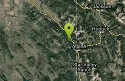
Palisades Hot springs
Swan Valley, Idaho
38.2 miles SWLegend has it... The hot water flows right into the lake. Feel free to dig your own little hot tub in the sand.
Hot Springs, Swim 17.5 mi
Tear Drop Lake
Ashton, Idaho
38.3 miles NWNestled in the Targhee National Forest just off of Ashton's Fish Creek Road, this tear drop shaped lake is a family adventure waiting to happen. The lake isn't very big but it is teeming with...
Camp, Canoe, Hike, Kayak, Mountain Bike, Swim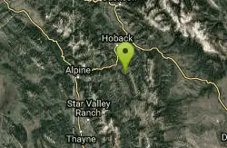
Bailey Lake
Jackson, Wyoming
38.3 miles SBailey Lake is located on the Guyandotte River in Wyoming and Mingo Counties in West Virginia, 3.3 miles (5.3 km) east of Justice. Originally referred to as Justice Reservoir, the lake was named by...
Camp, Hike, Horseback, Mountain Bike 0.3-0.6 mi
Bear Gulch
Ashton, Idaho
38.4 miles NWBear Gulch is an abandoned ski hill out of operation since 1969. While the vegetation is beginning to take over, there's still some great sledding to be had. It's just far enough into the...
Camp, Cross-country Ski, Hike, Sled

The Pit
Ashton, Idaho
38.6 miles NWThis location is great because there is no one around only locals know of this area and you can shoot anything out there. Watch out for target shooters there! Also stay away from the main road.
Airsoft, Paintball 13.2-13.5 mi
Bear Creek Hot Springs
Irwin, Idaho
38.7 miles SWBear Creek Hot Springs is a 15 mile out and back trail with a hot spring at the end. The trail is not well marked and is only recommended for very experienced outdoorsmen and primarily used for...
Backpack, Camp, Hike, Horseback, Hot Springs, Mountain Bike
Wolverine Creek Trail
Ririe, Idaho
38.8 miles WThe Wolverine Creek Trail is a doubletrack trail in Ririe, Idaho. It begins at South Fork Road and ends at Wolverine trailhead. It is commonly used by dirt bikes and four wheelers. This trail is...
Mountain Bike 0.1 mi
Lewis Lake Campground
Grant Village, Yellowstone National Park
38.9 miles NLewis Lake is located in the southern part of Yellowstone National Park. It is 4 miles southeast of Shoshone Lake. Lewis Lake offers a plethora great water activities. This lake offers...
Camp, Canoe, Kayak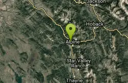
Alpine Campground
Alpine, Wyoming
39.1 miles SLocated two miles west of Alpine, Wyoming. Campground is situated in lodgepole pine trees, on flat terrain, and subject to wind and summer thunderstorms. Area is located near the south end of...
Camp 0.6-2.2 mi
Fish Creek Area
Ririe, Idaho
39.5 miles WFish Creek is a network of mountain bike trails up in the Big Hole Mountains. The trails are easily accessed from either the Ririe or Rexburg side of the range. The trail system is set up much...
Hike, Mountain Bike 29.6 mi
Ashton to Tetonia Trail
Ashton, Idaho
40.3 miles NWThe Idaho Department of Parks and Recreation undertook the project to transform the old Teton Valley Branch of the Union Pacific Railroad from Ashton to Tetonia into a trail for bikes, ATVs, and...
Mountain Bike 4.3 mi
Leaning Fir #169
Ririe, Idaho
40.5 miles WMountain Bike near Ririe, Idaho
Mountain Bike
Kelly Canyon Loops
Ririe, Idaho
40.8 miles WThis mountain bike trail near Kelly Canyon Ski Area has several options available. Highlights are the views in all directions from the top of the mountain. Trails: Waterfall...
Mountain Bike
South Fork Fall Creek Trail
Swan Valley, Idaho
40.9 miles SWOHV trail.
Mountain Bike 11.9 mi
Waterfall Loop
Ririe, Idaho
40.9 miles WTrail is a mixture of single track, forest road and double track. Provides a variety of scenery. About 1400 feet of elevation change throughout the trail.GPS is a must unless you are going with...
Mountain Bike 0.5-3.5 mi
Webster's Dam
Ririe, Idaho
40.9 miles WAlso known as Manmade Falls or the Woodmansee Dam, Webster Dam is an abandoned dam located deep in Moody Creek canyon, the dam was abandoned when sediment built up behind the dam which then...
Camp, Hike, Mountain Bike
Lower Hawley Gulch Trail
Ririe, Idaho
41.0 miles WThis is a singletrack biking trail in Ririe, Idaho. The trail is mainly flat with a few gradual slopes. You may have to carry your bike over obstacles such as fallen trees, logs, and small ponds....
Mountain Bike
Table Rock Campground
Ririe, Idaho
41.0 miles WTable Rock / Poison Flat Campground is located at the Caribou-Targhee National Forest which occupies over 3 million acres and stretches across southeastern Idaho, from the Montana, Utah, and Wyoming...
Camp


