


52 Hiking Trails near Spanish Fork, UT 84660
first prev 1 2 3 next lastShowing Hiking Trails within 50 miles Distance miles of Spanish Fork, UT 84660, USA City, Zip, or Address

Dripping Rock
Spanish Fork, Utah
3.7 miles SEDripping Rock is along a paved path adjacent to Spanish Oaks Golf Course.
Hike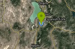
P Mountain and Little Mountain
Payson, Utah
6.4 miles SWP Mountain and Little Mountain is Payson's hometown hike, a short, rewarding ridge walk in the Uinta-Wasatch-Cache National Forest that leads to the point above the giant white "P" overlooking town,...
Hike
Bicentennial Park
Provo, Utah
7.0 miles NA 16-hole disc golf course in Provo beside a duck pond, a playground, a boardwalk nature trail with natural springs, and mature trees that make even moderate holes a genuine challenge.
Disc Golf, Hike, Sled
Y-Mountain Summit Trail
Provo, Utah
9.4 miles NA 1.2-mile climb east of BYU leads to a massive block Y on the hillside and sweeping panoramas over Provo, Orem, Utah Valley, and Utah Lake below.
Camp, Hike
Grotto Falls
Payson, Utah
11.3 miles SA gentle wooded creek trail with bridges leads to a waterfall and limestone grotto you can crawl around — all ages welcome and especially stunning in fall color season.
Hike 4.7 mi
Fifth Water Hot Springs
Provo, Utah
16.0 miles EA scenic 2.5-mile riverside hike to the famous Diamond Fork rock pools and waterfall, with soaks up to 108°.
Backpack, Camp, Hike, Hot Springs, Mountain Bike, Swim
Provo River Parkway Trail
Provo, Utah
17.2 miles NA fully paved 6-mile canyon ride from Vivian Park to the mouth of Provo Canyon, passing waterfalls and a fish-feeding spot — best done with two cars for a car-shuttle downhill.
Hike, Mountain Bike 1.2 mi
Battle Creek Falls
Pleasant Grove, Utah
17.3 miles NA short 1.2-mile family-friendly hike in Pleasant Grove to a scenic waterfall with views from below and above, plus a nearby rappelling and rock climbing area just beyond the falls.
Canyoneer, Hike
G Mountain Trail
Pleasant Grove, Utah
17.3 miles NA family-friendly 1.5-mile roundtrip hike from Kiwanis Park to a hillside 'G' landmark near Pleasant Grove — a little steep at the start and the end, but great for all ages.
Hike
Grove Creek Trail
Pleasant Grove, Utah
18.2 miles NA steep, shuttled downhill singletrack dropping from the shoulder of Mount Timpanogos through Grove Creek Canyon — the climb is brutal, but the descent is worth it.
Hike, Mountain Bike
Stewart Falls
Provo, Utah
20.2 miles NA glacier-fed, 200-foot multi-tiered waterfall on Mt. Timpanogos — about a 4-mile round trip hike through forest with a few steep edges near the falls.
Hike
Timpanogos Falls
Provo, Utah
20.2 miles NA lesser-known multi-tiered waterfall on the Mt. Timpanogos trail, visible early on and surrounded by wildflowers in late spring — a great beginner hike shared with the Stewart Falls trailhead.
Hike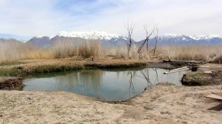
Saratoga Hot Springs
Saratoga Springs, Utah
20.9 miles NWThree naturally heated pools around 100°F year-round, a muddy beautiful setting, and an easy walk to nearby Utah Lake for wildlife watching between soaks.
Hike, Hot Springs 1.6-14.1 mi
Mount Timpanogas
Provo, Utah
21.9 miles NUtah's most-climbed mountain towers 7,000 feet above the Provo valley, stretching seven miles north to south with multiple peaks over 11,000 feet — a Wasatch landmark.
Camp, Hike, Horseback, Swim 0.3 mi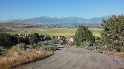
Kiowa Valley Path
Eagle Mountain, Utah
22.8 miles NWA 0.3-mile paved path affectionately dubbed 'Lizard Hill' by local kids — easy on any stroller, gentle enough for all ages, and filled with basking lizards and rabbits along the way.
Hike 1.5 mi
Timpanogas Cave
Provo, Utah
22.9 miles NColorful cave formations — cave bacons, columns, flowstone, and drapery — inside a Timpanogos mountain cave, reached by a 1.5-mile paved trail; tours run May through September.
Backpack, Cave, Hike 1.7 mi

Schoolhouse Springs Trail
Alpine, Utah
26.0 miles NA short, scenic trail at 5,300 feet in Alpine, Utah, featuring a lake and activities from horseback riding to hiking — best enjoyed between May and October.
Hike, Mountain Bike 1.3 mi
Eagle Crest Trail
Draper, Utah
26.5 miles NA beginner-level 2.4-mile mountain bike trail along the north side of Traverse Mountain in Draper, with sweeping views of Salt Lake Valley, Mount Timpanogos, Lone Peak, and Box Elder Mountain.
Hike, Mountain Bike
Mercer Hollow Trail
Draper, Utah
26.6 miles NA fast, flowy descent on the southern flank of Corner Canyon Ridge, packed with berms, rock features, rollers, and a quick uphill that rewards you on the way back down.
Hike, Mountain Bike 1.7 mi
Jacob's Ladder Trail
Sandy, Utah
27.5 miles NJacob's Ladder is the steep, relentless local favorite for climbing into the Lone Peak Wilderness above Draper, Utah — and a legendary technical descent.
Hike, Mountain Bike


