


Kiowa Valley Path
Eagle Mountain, Utah
| Address: | Eagle Mountain, UT 84005, USA |
| GPS: |
40°20'40.0"N 111°57'55.8"W Maps | Directions |
| State: | Utah |
| Trails/Routes: | 0.3 mi |
Hike
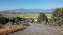
At 0.3 miles, this short little hike is almost more of a quick dog walk but kids seem to enjoy the lizards and rabbits that frequent the path. The lizards seem to enjoy basking in the heat of the paved trail. The path is affectionately known to kids in the area as Lizard Hill.
The trail is nicely paved making it easy for just about any kind of stroller. The trailheads are a little steep but other than than, it's about as easy as it gets.
More Information
Add ResourceBe courteous, informed, and prepared. Read trailhead guidelines, stay on the trail, and don't feed the wildlife.
Read More- Plan Ahead and Prepare
- Travel & camp on durable surfaces
- Dispose of waste properly
- Leave what you find
- Minimize campfire impacts
- Respect wildlife
- Be considerate of other visitors
Directions
From Eagle Mountain, Utah
- Head east on S Independence Way toward Revere Way (433 ft)
- Continue onto Church Way (0.1 mi)
- At the traffic circle, take the 1st exit (190 ft)
- Turn left onto Bobby Wren Blvd (0.3 mi)
- Turn right at the 1st cross street onto Pony Express Pkwy/Sweetwater NContinue to follow Pony Express Pkwy(5.0 mi)
- Turn right onto W 6400 N/Porters Crossing Pkwy (0.8 mi)
- Turn right onto E Golden Eagle Rd (0.1 mi)
- At the traffic circle, take the 3rd exit onto N Kiowa Pkwy (0.4 mi)
- Turn left onto E Yakima WayDestination will be on the right(0.1 mi)
endovereric
6/20/16 5:38 pm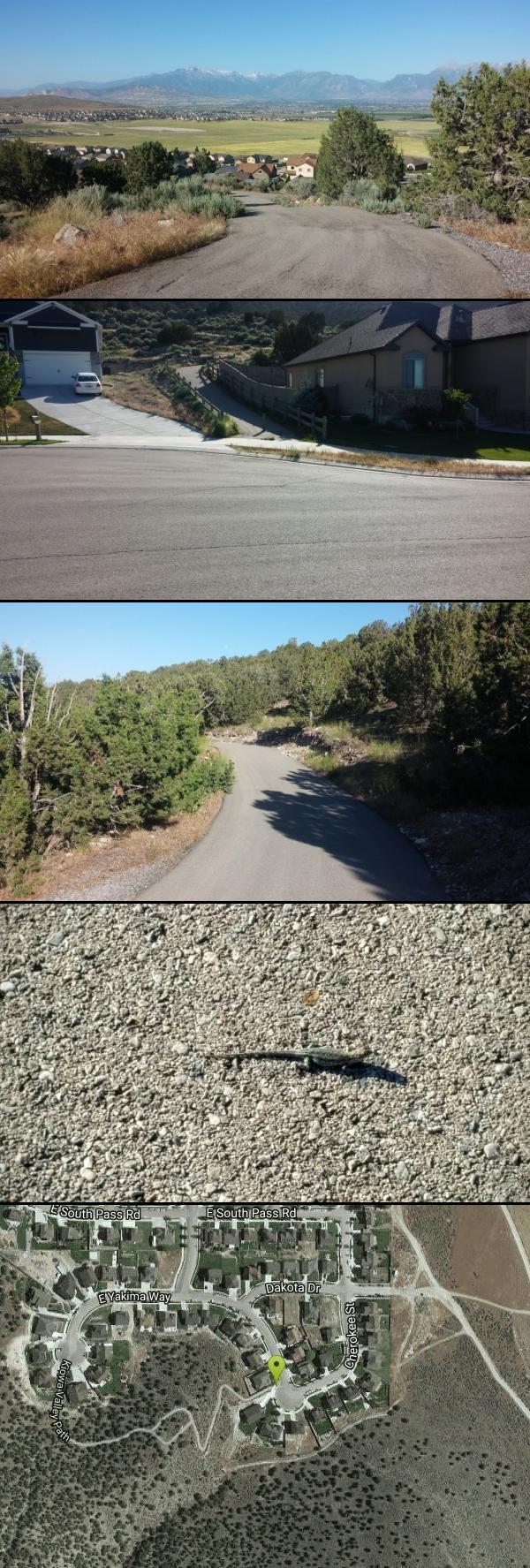


Other Hiking Trails Nearby
Saratoga Hot Springs
Saratoga Springs, Utah
3.5 miles EThree naturally heated pools around 100°F year-round, a muddy beautiful setting, and an easy walk to nearby Utah Lake for wildlife watching between soaks.
Hike, Hot Springs 1.3 mi
Eagle Crest Trail
Draper, Utah
11.1 miles NEA beginner-level 2.4-mile mountain bike trail along the north side of Traverse Mountain in Draper, with sweeping views of Salt Lake Valley, Mount Timpanogos, Lone Peak, and Box Elder Mountain.
Hike, Mountain Bike 0.8 mi
Red Rock Trail
Draper, Utah
11.3 miles NEA one-mile cliff-edge loop delivers sweeping Salt Lake Valley views and beginner-to-intermediate rock climbing on five walls with dental-themed route names.
Hike, Mountain Bike, Rock Climb
Little Valley Trail
Draper, Utah
11.6 miles NESuperbly constructed flow trails in a small Draper valley that are just as fun for adults as for kids — with connections to Corner Canyon for a longer ride.
Hike, Mountain Bike 0.6 mi
Potato Hill Trail
Draper, Utah
11.7 miles NEA short, paved trail system in Draper that connects Potato Hill to the Bonneville Shoreline Trail — combine with Red Potato and Lexie and Ethan trails for a 3-mile loop with smooth climbing.
Hike, Mountain Bike
Mercer Hollow Trail
Draper, Utah
11.9 miles NEA fast, flowy descent on the southern flank of Corner Canyon Ridge, packed with berms, rock features, rollers, and a quick uphill that rewards you on the way back down.
Hike, Mountain Bike 1.6 mi
Corner Canyon Trail
Draper, Utah
12.7 miles NEA go-to mountain biking area in South Salt Lake mixing beginner training trails in Little Valley with big table tops and wall rides in Maple Hollow.
Backpack, Hike, Mountain Bike 0.6 mi
Bst To Equestrian Center Loop
Draper, Utah
12.8 miles NEA 10-mile intermediate singletrack loop in Draper connecting the Bonneville Shoreline Trail and Equestrian Center with 417 feet of elevation along varied terrain.
Hike, Mountain Bike 0.2-1.8 mi
Lone Peak
Draper, Utah
13.0 miles NEOne of the Wasatch Front's taller peaks at over 11,000 feet, Lone Peak offers five different trailhead approaches, a 9-mile average round trip, rugged canyon terrain, and stunning Salt Lake valley views.
Hike, Mountain Bike, Rock Climb 1.2 mi
Ghost Falls Trail
Sandy, Utah
13.0 miles NEA family-friendly hike in Corner Canyon that winds through sandy rocky slopes and dry creek beds to the Ghost Falls loop, with helpful trail signs at the confusing intersections.
Hike, Mountain Bike, Snowshoe 1.7 mi
Jacob's Ladder Trail
Sandy, Utah
13.0 miles NEJacob's Ladder is the steep, relentless local favorite for climbing into the Lone Peak Wilderness above Draper, Utah — and a legendary technical descent.
Hike, Mountain Bike
Grove Creek Trail
Pleasant Grove, Utah
13.6 miles EA steep, shuttled downhill singletrack dropping from the shoulder of Mount Timpanogos through Grove Creek Canyon — the climb is brutal, but the descent is worth it.
Hike, Mountain Bike 0.5 mi
Draper City Park
Draper, Utah
13.7 miles NEA spacious Draper city park near the Porter Rockwell and Willow Creek trailheads, featuring two lighted pavilions, four baseball fields, playgrounds, and a famous central willow 'Tree of Life.'
Hike
G Mountain Trail
Pleasant Grove, Utah
14.0 miles EA family-friendly 1.5-mile roundtrip hike from Kiwanis Park to a hillside 'G' landmark near Pleasant Grove — a little steep at the start and the end, but great for all ages.
Hike 1.2 mi
Battle Creek Falls
Pleasant Grove, Utah
14.0 miles EA short 1.2-mile family-friendly hike in Pleasant Grove to a scenic waterfall with views from below and above, plus a nearby rappelling and rock climbing area just beyond the falls.
Canyoneer, Hike 0.8 mi
Bear Canyon Suspension Bridge
Draper, Utah
14.1 miles NEA 4.5-mile moderate hike in Draper connecting to a 185-foot suspension bridge over Bear Canyon, with sweeping Salt Lake Valley views and dozens of additional trails branching off nearby.
Hike, Mountain Bike 1.7 mi
Schoolhouse Springs Trail
Alpine, Utah
14.4 miles NEA short, scenic trail at 5,300 feet in Alpine, Utah, featuring a lake and activities from horseback riding to hiking — best enjoyed between May and October.
Hike, Mountain Bike 0.2 mi
Orson Smith trail
Draper, Utah
14.4 miles NEA short Draper foothills trail leading to a popular suspension bridge completed in 2015 at Bear Canyon — connecting to the Bonneville Shoreline Trail and open to hikers, bikers, and bird watchers.
Hike, Mountain Bike 1.5 mi
Timpanogas Cave
Provo, Utah
15.3 miles NEColorful cave formations — cave bacons, columns, flowstone, and drapery — inside a Timpanogos mountain cave, reached by a 1.5-mile paved trail; tours run May through September.
Backpack, Cave, Hike 0.4 mi
Hidden Valley Park trail
Sandy, Utah
15.7 miles NEA hidden shallow valley of grass, sandstone cliffs, and Navajo Sandstone domes just south of Moab — loop options total about one mile, but bring water because it gets hot.
Hike, Mountain BikeNearby Campsites

Mount Timpanogas
Provo, Utah
18.2 miles EUtah's most-climbed mountain towers 7,000 feet above the Provo valley, stretching seven miles north to south with multiple peaks over 11,000 feet — a Wasatch landmark.
Camp, Hike, Horseback, Swim
Y-Mountain Summit Trail
Provo, Utah
20.1 miles EA 1.2-mile climb east of BYU leads to a massive block Y on the hillside and sweeping panoramas over Provo, Orem, Utah Valley, and Utah Lake below.
Camp, Hike
Spruces Campground
Salt Lake City, Utah
26.7 miles NEA fee campground in Big Cottonwood Canyon near Salt Lake City — check USDA.gov for current rates and seasonal availability.
Camp, Sled
Mill Creek Canyon
Salt Lake City, Utah
27.9 miles NEAn out-and-back canyon trail with over 1,000 feet of elevation gain — the lower ski trail sees heavy traffic while the upper section above Elbow Fork stays quiet, with a reservable Yurt at the top December through April.
Camp, Cross-country Ski, Snowshoe 4.7 mi
Fifth Water Hot Springs
Provo, Utah
36.9 miles SEA scenic 2.5-mile riverside hike to the famous Diamond Fork rock pools and waterfall, with soaks up to 108°.
Backpack, Camp, Hike, Hot Springs, Mountain Bike, Swim
Holbrook Trailhead
Bountiful, Utah
37.7 miles NThe Holbrook Trailhead is a popular access point for the Bonneville Shoreline Trail and Holbrook Canyon above Bountiful, Utah, on the western face of the Wasatch. Perched on the bench right at the...
Airsoft, Backpack, Camp, Paintball, Snowshoe
Antelope Island State Park
Syracuse, Utah
49.4 miles NTwenty miles of trails cross Utah's Great Salt Lake island alongside free-roaming bison, antelope, and bobcats — best visited in early spring or late fall to beat the bugs.
Backpack, Camp, Hike, Horseback, Mountain Bike 5.6 mi
Antelope Island Lakeside Trail
Syracuse, Utah
49.5 miles NAn easy 2-hour loop on Antelope Island around the Great Salt Lake, with rock formations, views of the Sierra Nevadas, and the GSL — kid-friendly and good for bug fans.
Camp, Hike, Horseback


