


Provo River Falls
Kamas, Utah
| Address: | UT-150, Kamas, UT 84036, USA |
| GPS: |
40°39'27.5"N 110°56'45.1"W Maps | Directions |
| State: | Utah |
Hike
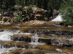
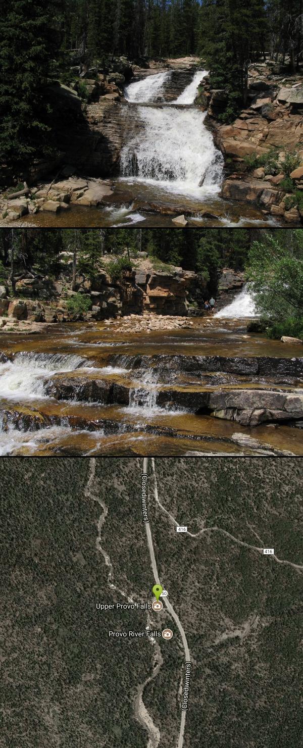
From the highway on the way to Mirror Lake, drivers will see the Provo River flow and cascade over several waterfalls on its way to the valley. Both the upper and lower falls are visible and during the early summer can be quite high from snowmelt. This is a very easy and accessible hike for anyone. Pull off from the highway into the parking lot and the waterfall easily comes into view. There are paths that provides additional vantage points for seeing both the upper and lower falls.
There are three different cascades to this waterfall. The first part can be seen from the parking lot, where there is a retaining wall and established viewing area. The second cascade can be seen along a trail, though in order to get a good picture, visitors will have to get a little closer to the edge. The third cascade is also visible from the trail, though visitors can get right up next to it if they carefully descend down the trail. The best picture for the third cascade might require actually going into the river or one of the close rocks along the shore.
Visitors can wade in the water, however the current can be swift when all the snowmelt is flowing. Also, the water is especially cold, so most won't stay in the water for very long. This is also a great place to go fishing, and people can be seen along the banks any day.
More Information
Add ResourceBe courteous, informed, and prepared. Read trailhead guidelines, stay on the trail, and don't feed the wildlife.
Read More- Plan Ahead and Prepare
- Travel & camp on durable surfaces
- Dispose of waste properly
- Leave what you find
- Minimize campfire impacts
- Respect wildlife
- Be considerate of other visitors
Directions
From Kamas, Utah
- Head north on S Main St toward E Center St (56 ft)
- Turn right at the 1st cross street onto UT-150 E/E Center StContinue to follow UT-150 EParts of this road may be closed at certain times or daysDestination will be on the left(23.8 mi)
The parking lot for viewing the Upper Falls is between mile marker 23 and 24 on the Mirror Lake Highway.

Other Hiking Trails Nearby

Mirror Lake
Salt Lake City, Utah
4.4 miles NEMirror Lake is a beautiful recreation area packed with opportunities to experience nature. Because of the stillness and clarity of the water, Mirror Lake is a beautiful reflection of the surrounding...
Backpack, Hike, Mountain Bike, Swim
Hell Hole Lake
Evanston, Utah
10.2 miles NEThe first 250 feet of this trail are on private property with access provided by Kayenta. The trail is actually the northern portion of Dry Wash. Sand and boulders litter the wash making hiking...
Camp, Hike, Horseback
Wasatch Crest
Salt Lake City, Utah
32.1 miles WThe Wasatch Crest Trail (GWT) is probably one of the best, if not the very best, singletrack trail in Utah! I prefer to do this ride as an out and back, starting at Millcreek Canyon's Big Water...
Hike, Mountain Bike
Silver Lake (Big Cottonwood)
Brighton, Utah
33.7 miles WThis hike has everything. The trail passes by three bodies of water and winds through beautiful woodland areas. Wildlife is in abundance. Everything from chipmunks to moose can be observed along...
Hike, Mountain Bike
Cecret (Secret) Lake
Alta, Utah
36.0 miles WCecret (pronounced "Secret") Lake is a beautiful lake located among alpine meadows in Little Cottonwood Canyons Albion Basin. Some folks spell Secret Lake as Cecret Lake, but the USGS...
Hike
Sugarloaf Peak
Alta, Utah
36.2 miles WSugarloaf Peak is an easily reached 11,000 ft. summit which overlooks Albion Basin, Secret Lake, and much of Utah's Alta ski resort. The easy terrain and relatively high trailhead elevation...
Hike
Donut Falls
Salt Lake City, Utah
36.8 miles WVery popular beginning hike in the Salt Lake City area. Many take this as a good intro hike into the outdoors, while others go for a trip out with friends to escape the rush of daily life. The...
Hike, Swim
American Fork Twin Peaks
Provo, Utah
38.0 miles WAmerican Fork Twin Peaks is the highest mountain on the Little Cottonwood Canyon ridge. The summit is the prominent peak overlooking the Snowbird ski resort. A short approach hike...
Hike
Timpanogos Falls
Provo, Utah
38.7 miles SWOne of the many waterfalls in the Mt Timpanogos area, Timpanogos Falls is a lesser known and visited waterfall. The trail for Timpanogos Falls departs from the same parking lot as Stewart Falls,...
Hike
Stewart Falls
Provo, Utah
38.9 miles SWStewart Falls is found nestled in the forest along the east side of Mt. Timpanogos. Fed by a glacier on the mountain, the crystal clear falls will leave visitors refreshed on a warm summer day. Those...
Hike
Pfeiferhorn Peak
Provo, Utah
39.0 miles WThe Pfeifferhorn is a majestic peak, which is located east of Salt Lake City, Utah in the Wasatch mountain range. It's easy access, proximity to alpine lakes and short trail make it a popular...
Backpack, Hike
Provo River Parkway Trail
Provo, Utah
39.1 miles SWThis isn't quite as much mountain biking as it is an easy downhill bike ride. The whole trail is paved. One of the best ways to do it is to take two vehicles and park one at Will's Canyon...
Hike, Mountain Bike
White Pine Lake
Sandy, Utah
39.4 miles WWhite Pine Canyon has long been the subject of intense controversy between advocates of wilderness and ski resort owners. The original boundaries of Lone Peak Wilderness Area, created in 1977, were...
Hike, Mountain Bike
Lake Blanche
Salt Lake City, Utah
39.4 miles WLake Blanche is a fun and popular hike. Lake Blanche, Lake Florence and Lake Lillian are all located next to each other in the upper reaches of the South Fork of Mill B. The trail to Lake Blanche...
Hike 1.6-14.1 mi
Mount Timpanogas
Provo, Utah
39.7 miles SWMt. Timp, as the locals call it, is the 2nd highest mountain in the Wasatch range (only Mt. Nebo is higher). What sets "Timp" apart is its location. It towers over the Provo, Orem, Pleasant...
Camp, Hike, Horseback, Swim
Hidden Falls
Salt Lake City, Utah
40.8 miles WHidden Falls is a popular road side attraction for anyone cruising Big Cottonwood Canyon on a sunny afternoon. The falls are within strolling distance of the parking lot and only require about 15...
Hike
Lisa Falls
Sandy, Utah
41.4 miles WLisa Falls is a great place to climb Spring through Fall, any time of day. The base is well shaded by trees and offers many flat places to belay, or just hang out and relax. The roaring waterfall...
Hike, Rock Climb
Storm Mountain
Salt Lake City, Utah
41.9 miles WStorm Mountain is on of the smaller peaks included in the Wasatch Range. Storm Mountain is located in Cottonwood Canyon. Storm Mountain Day Use Area is just 3 miles up Big Cottonwood Canyon,...
Hike, Mountain Bike, Rock Climb 0.7 mi
Great White Icicle
Sandy, Utah
42.2 miles WThe Great White Icicle is located in Little Cottonwood Canyon just outside of Salt Lake City, Utah. It is a climbing area that is a frozen waterfall in the winter and a cascading waterfall...
Hike, Rock Climb 2.6 mi
Salt Lake Valley Scenic Overlook
Salt Lake City, Utah
42.4 miles WThe Salt Lake Valley Scenic overlook starts on the Desolation trail in Millcreek Canyon near Salt Lake City, Utah and offers hikers a wide variety of destinations to stop at along the trail,...
HikeNearby Campsites
Hell Hole Lake
Evanston, Utah
10.2 miles NEThe first 250 feet of this trail are on private property with access provided by Kayenta. The trail is actually the northern portion of Dry Wash. Sand and boulders litter the wash making hiking...
Camp, Hike, Horseback
Spruces Campground
Salt Lake City, Utah
36.3 miles WCamping isn't free. See USDA.gov for details. If you know the coordinates of the sledding hill here, please comment.
Camp, Sled 1.6-14.1 mi
Mount Timpanogas
Provo, Utah
39.7 miles SWMt. Timp, as the locals call it, is the 2nd highest mountain in the Wasatch range (only Mt. Nebo is higher). What sets "Timp" apart is its location. It towers over the Provo, Orem, Pleasant...
Camp, Hike, Horseback, Swim
Mill Creek Canyon
Salt Lake City, Utah
40.3 miles WMill Creek is an out and back with over 1000 ft of elevation gain. The lower section of the ski trail gets a lot of foot traffic, but the upper section (above Elbow Fork) is generally very quiet....
Camp, Cross-country Ski, Snowshoe
Y-Mountain Summit Trail
Provo, Utah
45.0 miles SWY Mountain is located directly east of Brigham Young University (BYU) in Provo, Utah, United States. The Slide Canyon/Y Mountain Trail leads to a large block Y located 1.2 miles (1.9 km) from a...
Camp, Hike 4.7 mi
Fifth Water Hot Springs
Provo, Utah
45.1 miles SWAKA Diamond Fork Hot Springs A beautiful drive and a 2.5 mile hike along the river will end you at an amazing set of hot springs that's well worth the trip. There's a variety of...
Backpack, Camp, Hike, Hot Springs, Mountain Bike, Swim
Holbrook Trailhead
Bountiful, Utah
49.4 miles Wairsoft feaild woth bunkers
Airsoft, Backpack, Camp, Paintball, Snowshoe


