


Refine Search
- hike 74
- mountain bike 31
- camp 30
- swim 24
- backpack 14
- sled 12
- cave 12
- canoe 12
- cross-country ski 10
- kayak 9
- rock climb 8
- disc golf 7
- dive 7
- horseback 7
- airsoft 6
- paintball 5
- snowshoe 2
- hot springs 2
- skateboard 2
83 locations
Add Location
 Full Listing
Rock Climb
Last visited on 30 May 2016
Full Listing
Rock Climb
Last visited on 30 May 2016
Full Listing
Rock Climb
Last visited on 25 May 2016
 Full Listing
Hike
Last visited on 2 May 2015
Full Listing
Hike
Last visited on 2 May 2015
 Full Listing
Airsoft, Paintball
Last visited on 18 Oct 2014
Full Listing
Airsoft, Paintball
Last visited on 18 Oct 2014
 Full Listing
Camp, Hike
Last visited on 6 Sep 2014
Full Listing
Camp, Hike
Last visited on 6 Sep 2014
 Full Listing
Sled, Swim
Last visited on 4 Jul 2014
Full Listing
Sled, Swim
Last visited on 4 Jul 2014
 Full Listing
Airsoft, Paintball
Last visited on 2 Apr 2014
Full Listing
Airsoft, Paintball
Last visited on 2 Apr 2014
 Full Listing
Dive, Swim
Last visited on 4 Jul 2013
Full Listing
Dive, Swim
Last visited on 4 Jul 2013
 Full Listing
Cave
Last visited on 4 Aug 2010
Full Listing
Cave
Last visited on 4 Aug 2010
 Full Listing
Camp
Last visited on 12 Aug 2006
Full Listing
Camp
Last visited on 12 Aug 2006
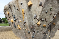
Phil Baux Park
Jackson, Wyoming
0.5 miles S of Jackson, WyomingPhil Baux park has your typical park equipment such as a playground, swing set, small picnic shelter, 8 picnic tables, horseshoe pits and plenty of green grass for other recreational activities.
What really makes this park unique is the Teton Boulder Project which consists of 3 large rock climbing structures. The structures are about 12 feet high and consist of natural style ledges and cracks as well as the screw on holds. There are overhangs and ascents. There are several marked routes. Skill levels range from the most beginner to the most advanced rock climbers.
Alongside the rock climbing walls is a memorial dedicated to those loved ones that have been lost to the mountains.
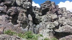
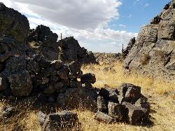
Basalt Bluff / Steve's Rock
Teton, Idaho
2.9 miles S of Teton, IdahoDon't go anywhere marked No Trespassing and Beware of the Attack Bees at the top of the cliffs and the Stinging Nettle at the bottom.
About a mile north of Loon Lake/Wentworth Springs Road junction, going towards Loon Lake, look up to the left to see this formation. Park on the road (narrow) and hike up to the the east face where all the climbs are. Can rappel off (2 ropes) or walk off to the north. Most routes are high quality with good rock. At last count there were 11 established routes here.
| Route | Difficulty | Ascents |
|---|---|---|
| 5.8 Hand Crack | 5.8 | 1 |
| Aoxomoxoa | 5.10b | 1 |
| Brown Shoes | 5.10c | 1 |
| Hangdogs Beget Eurodogs | 5.10a | 2 |
| Movin to Montana | 5.10c | 1 |
| Punk Titans Unchained | 5.10a | 1 |
| Three Ekka | 5.11a | 1 |
courtesy of RockClimbing.com
4.2 mi
 Full Listing
Backpack, Hike
Last visited on 27 Jun 2015
Full Listing
Backpack, Hike
Last visited on 27 Jun 2015
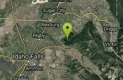
Lake Marie
Island Park, Idaho
9.7 miles N of Island Park, IdahoLake Marie sits on the North slope of Mount Jefferson in Fremont County, Idaho. The trail to get there cuts back and forth across the Idaho Montana border 4 times. Much of the trail is fairly flat along the ridge of the Continental Divide with mild ups and downs going each way. When the ridge begins to ascend toward Mount Jefferson, the trail vears North as it works it way across Jefferson. You'll go down some switchbacks through the trees which is about the only real shade on the trail. Then you'll travel West through a meadow full of wildflowers of all colors. After the meadow, you'll follow along the rocky trail across the Northern slope until it does a sharp turn to go back East. From there, there are a couple of options but essentially, you just need to head North until you see Rock Creek and ultimately drop in to Lake Marie.
Once you reach the lake, there is a beautiful meadow. with the trickling rock creek coming into it and another small stream leading out of it. Because Lake Marie is so freshly fed by the snowmelt from Mount Jefferson, the size varies dramatically between spring and fall but one thing will be constant: the water is cold.
Henry's Fork Green Way (St. Anthony Green Belt)
Saint Anthony, Idaho
0.6 miles SW of Saint Anthony, IdahoThis is a great walk along the river. While it is nestled right next to the highway, the closeness and beauty of the river flowing on the other side of the trail more than make up for it. Halfway along the trail, there's a statue of Andrew Henry and a loop that will take you right back for an easy 1 mile. The full length is a mile itself making a full 2 mile round trip.
Pet Friendly: Yes
Difficulty: Easy
Trail: Paved
Length:
- Statue Loop: 1 mile
- Full Round Trip: 2 miles
0.1-0.5 mi
 Full Listing
Camp, Hike, Mountain Bike, Sled
Last visited on 1 May 2015
Full Listing
Camp, Hike, Mountain Bike, Sled
Last visited on 1 May 2015
Eagle Park
Rexburg, Idaho
0.9 miles N of Rexburg, IdahoEagle Park is a little urban oasis. Once you drive in to this cottonwood forest along the river, you may forget that you're still inside Rexburg city limits. You can camp, picnic, throw rocks in the river, fish, mountain bike, or just go for a walk along the trail or road. All sites have picnic tables, fire rings, and tent pads. Just off the main parking lot is a nicely mowed grassy area that is a popular dog park. On the West end of the parking lot, you'll find a multi-use trail that will take you almost the entire length of the park.
Mountain Biking/Hiking/Walking
The trail system at Eagle Park is maintained in part by Free Arenas. If you have any would like to get involved or just want to share your thoughts on how to improve it, email [email protected].
Tenderfoot is primarily a mountain bike trail. The trail runs back behind most of the campsites. While it's built for mountain bikes, it's usually great for a nice quiet walk as well, and arguably the best way to see the park. This 0.5 mile trail is rated Easy but is about as tough as an easy trail can get. It's pretty mellow but does have a couple of very short ups.
Taut-line is cut into the slope along the fence line. It begins on the embankment at the West end of the campground and goes for 0.4 miles before meeting back up with Tenderfoot. The Northwest section is the longest section of trail in Eagle Park and is cut into a steep slope above marsh and ponds. It is generally downhill from the West end but has plenty of up and down. Towards the middle of the trail, there is a berm and a couple of table top jumps. The section South of the Tenderfoot junction was an Eagle Project completed by Ian Hoffman and his volunteer crew. The trail continues to cut up and down the side hill with a fun rock berm and a rock garden. The end drops in to connect back to Tenderfoot right near the junction with Bugler. The trail is a one-way trail from West to East and has short climbs and fun decents. Because it's much higher than the Tenderfoot Trail it parallels, Taut-line does not flood and actually bypasses the flood areas of Tenderfoot. Because the trail does go along a steep slope on the West end, remember to fall uphill. This trail is rated Intermediate.
Bugler drops off the Tenderfoot Trail and runs down and around a small pond just off the main lawn. There's a few decents, climbs, and berms adding a little bit of speed and a little more difficulty.
Jamboree drops off the Eagle Park Road near campsite 19 and continues down along the river to the old campsite 14 that's now a disc golf basket. This trail rolls back and forth through a trough of sorts with some jumps along the edges and potential for many more. It seeps ground water when the water is higher and is completely flooded in May/June when the river is really high. When it's dry though, it rides decently fast and is a lot of fun!
Skills Park Along the Tenderfoot Trail and just off the lawn is a skills park built as an Eagle Scout project by Erik Hurst and other volunteers. It features a large wrap-around berm on the north end, raised skinnies made of 2x8, 2x6, and 2x4 treated lumber, a ladder a-frame, a rock garden, and a see-saw.
While not all trails are intended to bi-directional and multi-use, they are all used as such so please be aware of others on the trail.
Looking for a little longer hike or ride? Go to the Northwest end of the park and you'll find an old embankment road that follows the airport fence line to the Nature Park. It's pretty popular to loop both parks together.
Sledding
There's some mounds above a bench that can be used as a sledding hill area just off the main grassy area. It's a terraced hill with a couple set runs and then quite a bit of open hill as well. Elevation is only about 20 feet from top to bottom but there's plenty to keep kids busy for awhile. There's even a more difficult run that includes jumps and drops for snowboards. The terrace trails are better when the snow's a little bit icier but the small hills are great for little kids that wnat to avoid the more popular hill at Smith Park
Camping
Picnicking is free but there is a fee for camping. Overnight camping fee is $10.00 per space paid via rexburg.org. All fees are used for future picnic tables, restrooms and other park improvements. The camp fee for boy scout troops may be waived as long as they perform an approved 1 hour service project to the park while camped here. Picking up garbage and pulling weeds are always approved. Weeds that need pulled include hounds tongue, cocklebur, bull thistle, and the occasional stinging nettle.
Posted Eagle Park Rules
- No RVs in park
- No motorcycles, scooters, or ATVs on park roads
- 7 day camping limit
- Tents only on designated tenting pads
- Fires in designated fire pits only. No non-burnable items in firepits.
- No smoking, tobacco, or alcoholic beverages
- Pets on leashes only. (All pet droppings to be put in bags for droppings)
- All garbage to be put in garbage cans. Pack it in - Pack it out.
- No firearms, firecrackers, or explosives
- Avoid loud music and noises — Be respectful of other campers
To reserve an entire shelter, call City Hall at 359-3020. Reservation fee is $25 per half day.
This is a community service project of Free Arenas, the Madison Lions Club, Trails of Madison County, the City of Rexburg, and numerous Eagle Scouts in the Yellowstone District of the Grand Teton Council, BSA. Constructed 2001-2005.
Please respect the flora and fauna and practice the Outdoor Code. This park only exists because of volunteer service from many in the community. Please, don't be afraid to help out by collecting some hounds tongue, cocklebur, and bull thistle. If you're looking for ideas for a bigger service project, contact [email protected]
Bighole Mountains / Moody
Ririe, Idaho
9.0 miles E of Ririe, IdahoThis is a little unofficial campground with a plenty of shade for your basecamp and a wooded field with great boundaries. There's 2 roads that split and merge giving you very simple boundaries. It's setup well to play from the SW to the NE and have one team wald. The SE half is about 15-20ft above the NW half but the transition's not to steep to run from the low side to the high side or vice versa. The NW side is fairly sparse but the SE side has a fair amount of brush cover. Even where there's not great barriers to hide behind, there are lots of trees to create some strategic line-of-sight cover.
One of the great things about this field is if you get there and it's taken, you can just drive a mile down the road and just go play in the trees.
Big Springs
Island Park, Idaho
7.6 miles NE of Island Park, IdahoThere's also a great little walking trail along the river with placards that tell about the ecosystem and history of the area. There's about a 1/2 mile that's paved and then a 1/2 mile of dirt trail. The trail is NOT a loop. The trailhead is on the South West side of the bridge. There's a great spot to feed the fish under the West side of the bridge so bring some quarters to buy fish food. The trail to Johnny Sack's Cabin is on the North Side of the Cabin.
Campground (Fee Required)
This campground Is located on the Ashton·lsland Park Ranger District, comprising nearly 650,000 acres of National Forest System lands. Numerous amenities are offered such as single and double sites which Includes fire rings. utlllty tables. picnic tables, and reslrooms. This campground is situated nen to the beautiful Henry's Fork shaded by Lodgepole Pines. Come In and relax with friends and family. Head on out and explore the Big Springs Interpretative Trail which starts at the bridge Just Outside the campground. Be sure to visit the historical Johnny Sack Cabin, offering a unique Insight Into the history of the Big Springs Area. Just follow the asphalt walkway which will take you to the cabin Just north of the campground. Explore the historical, cultural, geological, and recreational resources this area has to offer.
Take a scenic drive south along the Mesa Falls Scenic By·Way. Stop by the Mesa Falls Visitor Center for an interpretative tour and captivating view of Upper Falls. A two mile Interpretative hiking uall will offer you a view of Canyon Rim.
Length of Stay: Forest Order
Camping or occupying a Single site for a period longer than 16 consecutive days Is prohibited. After leaving a site, a minimum of 7 days Is required before any group or person(s) from that group may reoccupy their original location.
This limit of stay restriction Is necessary to reduce displacment of other Forest desiring to occupy a particular campsite, and reducing the opportunity for visitor or group of visitors from monopolizing a campsite for long periods time (in excess of 16 days).
Fire Safety: Only You Can Prevent Forest Fires
Make sure your fire is DEAD OUT
- NEVER leave a fire unattended.
- Keep your fires small. Firewood Is available for sale. See campground host.
- Check with campground host for current fire restrictions.
- Use existing fire rings. Scrape away litter end any other burnable material within a l0 foot-diameter circle surrounding the fire ring.
- Make sure all wood fits inside the fire ring.
- To put out a campfire, slowly pour water onto the fire and stir with a shovel until all material is cool to the touch.
- Do not bury your fire. The coals can smolder and re-ignite.
- Make sure the fire is dead out. Many wildfires have been caused by abandoned campfires.
Bear Country: Required Food Storage Order
Your Safety Is Important to Us
All food and other items that might attract bears must be stored where bears cannot access them at night and during the daytime when unattended. Attended means that a person is physically present within 100 feet and in direct sight of the food.
What are bear attractants?
- All food and anything that contacted food. This includes full or empty coolers, packaging, boxes, cans, bottles, dirty dishes and silverware, etc.
- All beverages and beverage containers, full or empty (including water)
- All garbage, food scraps, and cooking grease. Never dump grease, beverages, or scraps on the ground.
- Never leave garbage in your fire pit or outside.
- Pet food and pet food bowls.
- Gas cans.
- Grills. Burn grill for at least 5 minutes after use to get rid of any residues. Clorox the grease trap.
Anything with a strong odor is an attractant for bears. Attractants must be stored in a bear-resistant manner. If you are away from your campsite or asleep at night in your test/trailer/RV, these attractants MUST BE STORED. You may be fined if you do not properly store your attractants. If you cannot properly store your attractants, inform the campground host and a bear resistant container may be provided for you.
What is bear resistant storage?
Acceptable places to store and dispose of your attractants are inside a hard-sided trailer, an enclosed vehicle, inside a bear dumpster or trash can (this campground has bear-resistant dumpster). Coolers, tents, underneath your RV/trailer the back of pick-up trucks, boxes, beverage bottles, canned goods, soft-sided trailers, and other containers are not bear resistant. All garbage must go to bear-resistant dumpsters. Garbage must never be left outside unattended. If the dumpster is full, you must take your trash back with you and inform the campground host of the situation.
NOTICE: ATV and Motorcycle use is prohibited
ATVs and motorcycles are prohibited from use in this campground. The following are exempt:
- Licensed street legal motorcycles.
- Vehicles used by handicapped individuals.
- Vehicles used by campground hosts for their official duties.
ATVs and motorcycles may be trailered into the campground, kept in the campsite on a trailer, or parked at a location designated by the campground host.
Educate Yourself
Contact the Island Park or Ashton Ranger Station for information on which areas are open to ATVs.
If you have a Dog: Keep your pet secure at all times
In the national forest, you and your dog could meet people, horses, mountain bikes, ATVs, other dogs, and wild animals. Help make the outdoor experience enjoyable for you, your dog and all the forest's users by following these safety tips:
- Please remove all feces before vacating your site.
- Give your dog plenty of water and rest, and watch for signs of stress and fatigue.
- Keep your dog leashed and under control in campgrounds. Secure your pet in a shady spot and give it lots of attention to minimize barking.
- If you encounter wild animals, respect them by restraining your dog.
Fireworks are prohibited
Fireworks or other explosives are prohibited within campgrounds and other recreation sites.
Fishing Rules: A fishing license is required to fish in this forest
- A state fishing license is required to fish in this national forest.
- A fishing license can be purchased over-the-counter at various stores in the local area. For more information, contact Idaho Fish and Game.
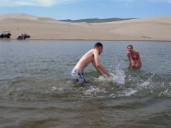
Egin Lakes
Saint Anthony, Idaho
8.9 miles W of Saint Anthony, IdahoEgin Lakes is one of the favorite gateways to the St. Anthony Sand Dunes. The lakes themselves are unusually shallow and where you'll actually find a lake depends greatly on what time of the summer you go. The earlier in the year, the larger the lake. If you do find a lake, you'll find plenty of shallow areas for water games. The 2-3 feet deep areas are great for tackle football, ultimate frisbee, volleyball, or any other running game you want to take to the water. If you come early in the summer you'll find the lake extended pretty far east into the sandiest parts. It's the closest you'll find to a real beach in Southeast Idaho.
There is a $5 per vehicle access fee which gets you into a great parking lot, parts store, showers. The Egin Lakes Campground also offers a potable water system, RV dump station and 48 improved camp units, including electrical service. If you do ride ATVs at the dunes, be sure to take all proper precautions, including a flag for visibility.
Rattle Rock / The Gauntlet
Menan, Idaho
6.6 miles N of Menan, IdahoRattle Rock is a much different arena than the flat or even hilly woods associated with rec ball or wooden scrap barriers like many established fields. You won't find any trees, spools, or straw bales here. This collapsed lava tube has created a gauntlet with 20 foot rock climbable rock walls on either side. Though wildfires in 2013 wiped out all of the large sagebrush and crumbled some of the manmade rock barriers, there's still plenty there to have a great time. There's still a lot of manmade rock walls, caves, and tunnels; at one time, there were over 40. A couple of the high vantage points have walls built around them to act as a turret. Surprisingly great place to play. If you're really adventurous, it can easily become an interesting bouldering/paintballing mix. There are plenty of Rattlesnakes out in desert and Rattle Rock is far from the exception. It's a good idea to walk the field and make sure all your opponents are human before you start playing. You'll want to check out the tunnels and caves as well. You wouldn't want to dive in there and find the spot already taken. Some people have played out here a lot and never seen a rattlesnake on the field but be cautious, safe, and play at your own risk.
If you continue down the road a bit more to the Southeast, there's a popular shooting spot that sometimes shoots towards The Gauntlet. Make sure there's nobody shooting your direction before you start to play. You may also consider putting a sign or something up over there to let people that may come know that you're up in the hill and would prefer not to be shot at.
0.1 mi
 Full Listing
Sled
Last visited on 15 Feb 2014
Full Listing
Sled
Last visited on 15 Feb 2014
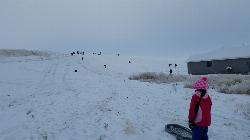
Founder's Square Hill (Under the Water Tower)
Rexburg, Idaho
1.8 miles SE of Rexburg, IdahoThis is a great sledding hill. It's about the perfect steepness and really wide. It's also big enough to make it worth a little run on a snowboard or an inner tube. While this is a pretty popular hill, it's pretty hard for it to get overcrowded.
In 2017, some houses were built at the bottom of the hill that make it a little less perfect but there's still plenty of hill for a good time. You just need to be respectful of the people's homes and the end of the slope. There's also a little winding rutted dirt road that comes down to the left of the hill that sometimes is a pretty great little run if the snow's just right.
0.8-1.3 mi
 Full Listing
Airsoft, Camp, Canoe
Last visited on 20 Sep 2013
Full Listing
Airsoft, Camp, Canoe
Last visited on 20 Sep 2013
Warm Slough Campground
Rexburg, Idaho
5.0 miles NW of Rexburg, IdahoThis is a pretty popular campsite that fills up pretty quick on busy weekends. Campsites are fairly spread out and there is no official donation box (as of July 2015). A couple of the campsites have picnic tables and there are several rock fire rings. There's also a restroom next to each boat ramp.
It's a popular put in and takeout spot on the river with two boat ramps, one on the creek and one on the river. There's also a pretty good spot to take out innertubes just under a mile downstream from the boatramp that's on the river, yet the boat ramp and takeout are only about 1000 feet away from each other which makes it really easy to do over and over again. There's another put-in further upstream that will almost double your float but also significantly increase your walk back. It's a pretty slow easy float and the water isn't super cold.
This used to be a popular spot for paintball which is now prohibited. Please take better care of the paintball fields we are permitted to use.
7.9 mi
 Full Listing
Hike
Last visited on 30 Aug 2013
Full Listing
Hike
Last visited on 30 Aug 2013
Borah Peak
Mackay, Idaho
18.7 miles NW of Mackay, IdahoThis is the highest peak in all of Idaho, standing 12,662 ft along the Lost River Range. There are several routes that can be taken in order to reach the summit with different levels of difficulty depending on the season. Mount Borah has been summited every month of the year, though the best season to climb is late summer or early fall.
The most common route used in climbing Mount Borah is Southwest "Chicken-out" Ridge. This is a Class 3-4 route, and if going in the summer/fall does not require any advanced or additional equipment. The trail starts through a pine forest and sage brush area. After the forested area, climbers will then go through some switchbacks as they make their way towards "Chicken-out" Ridge. The crux of the trail begins around 11,200 ft in elevation and at this point climbers must scramble, or use their hands on the steep trail, through the crux. There is a lot of exposure along the "Chicken-out" Ridge and for inexperienced climbers, this is the point where many turn back. For more experienced climbers, this part might not seem too bad and leave them wondering if they really have climbed through the worst section. While scrambling up the ridge, the last portion will have climbers scramble down. Exercise caution through this area because a snow knife-edge is present most of the year. Past this ridge the slope becomes a variety of different rocks, from scree and talus to bare slabs and ledges. At the top of Mount Borah is a registry, so feel free to sign it after reaching the top!
Other routes to the summit require either a lot of experience, or additional equipment, or in most cases both. Mount Borah is a great mountain to climb because there is something for every climber. Other routes include North Face Direct, North Face (traverse), Psycho Therapy, Borah Borah Borah, Northeast Ridge, Hidden Couloir, East Face Dye/Boyer, Dirty Traverse, East Face Direct, East Face-Northeast Ridge Variation, South Couloir, and Northwest Ridge.
3.8-6.4 mi
 Full Listing
Camp, Hike
Last visited on 3 Aug 2013
Full Listing
Camp, Hike
Last visited on 3 Aug 2013
Table Rock / Table Mountain
Driggs, Idaho
10.0 miles E of Driggs, IdahoAt 11,300 feet, Table Mountain is possibly the most beautiful climb this side of the Tetons and offers what may well be the very best view of the Grand Tetons. It's just far enough away to be able to see all three peaks and close enough to make out all the detail.
There are 2 main trails with different distances but either way, you've got to climb over 4000 feet.
The Face trail is much steeper but also much shorter. It cuts out all of the switchbacks and 'B' lines it for the top. It's considerably shorter and you don't have to go very far before the view begins to open up and you can see the beauty of Teton Canyon and its surrounding peaks. (about 3.5 miles one way)
Huckleberry trail is much longer but also a much more gradual incline/decline. The trail follows and crosses North Fork Teton Creek making it a great spot to get a filtered water refill.It's not known as huckleberry for nothing. You just have to catch it at the right time (Mid-Late Summer depending on weather) and get to the bushes before everybody else picks them clean. (about 6.5 miles one way)
Check conditions via webcam at tetoncam.com.
Elevation: 11,300ft
Elevation Gain: 4000ft
Length: 7-13 miles
0.1-0.3 mi
Full Listing
Disc Golf
Last visited on 13 Jul 2013
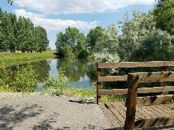
Rexburg Nature Park
Rexburg, Idaho
0.8 miles NW of Rexburg, IdahoRexburg Nature Park:
Life can be stressful, annoying, or just not good. Sometimes, it takes a moment to simply get away from the non-sense of this world; to gather yourself and seek peace and tranquility. That option is around the corner; you drive and see a trail, so you park and walk on the trail. As you walk, there's trees and sunlight shining on the leaves. You walk further and see a pond with ducks (both green and brown) and families sitting on the green grass with their kids; they watch, feed the ducks and take pictures with a smile on their face.
You go back to your vehicle and reminisce what you saw. Close to the south fork of the Teton River, is a nature park that isn't crowded with college students or infested with incoming traffic but a 15 acre park that was made so you can take your family or acquaintances for a picnic or a social gathering and enjoy; you also have the option to ride your bike or to jog on the trails.
The park is next to the Claire Boyle skate park, a beautiful golf course next to the fairgrounds and a 9 hole Frisbee golf course.
Features:
-Playground for the kids
-Fishing ponds ( A valid fishing license is required); fishing ponds for children as well.
-Wildlife and wildflowers
For more information and questions:
| Phone | 208-359-3020 Ext. 0 |
Twin Bridges
St. Anthony, Idaho
6.6 miles NE of St. Anthony, IdahoThere's an old abandoned bridge next to the one currently in use. The water is pretty deep underneath and offers two distinct levels to jump from. There's a little rope swing under the bridge and a path up river that makes a great put-in spot for a LITTLE float. If you've got little kids, there's a great little sandbar on the north side of the bridge just upstream from all the commotion. There are almost always people there on the nice days but you rarely ever have to wait to jump.
0.6-2.0 mi
 Full Listing
Camp, Cave, Hike
Last visited on 18 Jun 2013
Full Listing
Camp, Cave, Hike
Last visited on 18 Jun 2013
North Menan Butte ('R' Mountain)
Menan, Idaho
4.5 miles N of Menan, IdahoThe North Menan Butte is more commonly known to the locals and college students as R Mountain. Many kids know it better as Ou'R' Mountain. The butte is a rare and unique geological area and provides a great volcanic hike.
There's a paved parking lot and a vault toilet at the West trailhead. The first few hundred yards are well-maintained gravel and sand paths and the further you get, the less defined the trail gets, though it is relatively easy to find and follow. The switchback trails (South and West) are marked by sections of log fences. Towards the top of the West switchbacks, there's a chain handrail. It gets a little steep so you'll want some shoes with some grip. The sand on the rock makes it pretty slippery in the steeper parts. You'll get better grip after a good rain. Once you get up to the top, there's an informational placard. From there, it's easy to hike the rim and get an awesome view of the valley including Rexburg, Henry's Fork, and the Snake River.
It's a great hike for a small family or just a quick hike for a date. Even going up the West switchbacks and around rim, including the 'R', and back down the same way is only 3.5 miles (longest route) so you can do it pretty quick if you want. There's so much to look at that you could also spend hours climbing rocks, exploring caves, and playing around "The Ampitheater". If you just want to get to the 'R' as quickly as possible, you can do the hike in as little as 2 miles roundtrip.
Distances:
- West trailhead up the face to the rim: 0.5 miles
- West trailhead up the switchbacks to the rim: 0.75 miles
- West trailhead, from reaching the rim to 'R': 1 mile
- South trailhead to the rim: 0.3 miles
- South trailhead, from reaching the rim to 'R': 0.75 mile
- Through the caldera: 0.6 miles
- Around the rim: 2 miles
- Rim to 'R': 500 feet
There are no fees. Camping is allowed up to 5 nights but fires must be in an elevated fire pan and all the ash must be packed out.
Posted regulations:
- No motorized vehicle use
- Discharging of weapons or fireworks is prohibited
- Open fires are permitted only with an approved elevated fire pan and ash removal
- Burning pallets, tires, wire, plastic, glass, metal, magnesium, or hazardous material is prohibited
- Cutting or damaging vegitation is prohibited
- 5-day camping limit
0.3-0.6 mi
 Full Listing
Hike
Last visited on 16 Jun 2013
Full Listing
Hike
Last visited on 16 Jun 2013
Cress Creek Nature Trail
Rexburg, Idaho
11.9 miles S of Rexburg, IdahoMeandering along the scenic South Fork of the Snake River, the beautiful 1¼ mile Cress Creek Nature Trail will lead you on a journey through sagebrush-grass communities, over juniper covered slopes, and along a lush perennial creek. Cress Creek derives its name from the watercress plant, a favorite food of the moose that live in this area. With clear skies, prepare for an expansive view of the Snake River, volcanoes and farmland. The site offers ample parking, restrooms and trail accessibility, which attract a wide spectrum of trail users to the area. You will become familiar with life in the Cress Creek area as it is now and as it was long ago. If you hike quietly you may see deer, rabbits, small lizards, or possibly an eagle or a moose. The nature trail is self-guided with many beautiful interpretive signs posted along the way to assist you. The first half-mile of the trail is accessible by wheelchair.
On the northeastern corner of the trail, there's an overlook trail. Parts of it are pretty nice like the rest of the loop but some is barely recognizable as a trail. Parts of the trail are steep and parts of it go over some pretty loose rock. It goes for about a ½ mile all the way to the top of the hill. Just below the rim, there are several really cool caves. From the top, you can see from Rexburg to Idaho Falls.
5.9-9.1 mi

Sand Point
Forks, Washington
19.2 miles NW of Forks, WashingtonBackpack and Hike near Forks, Washington
Full Listing
Backpack, Hike
Last visited on 16 Jun 2011
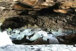
Civil Defense Caves
Rexburg, Idaho
23.0 miles N of Rexburg, IdahoThe caves are large lava tubes. The name comes from the cold war era when they were anticipated as a safe area in the case of an attack. The entrance is pretty bouldery and does require a small amount of agility. Once in, it's easy enough for even little kids. Off the entrance, there are two main tubes. The right is pretty easy, the left is a little more difficult but does have bats. The right tube is mostly a flat gravely floor with a very large arched ceiling with rocks and boulders here and there. There's plenty of room to run around. College kids often play glow in the dark tag and other similar night games out here. It's pretty well patroled due to the high interest. At the end is a little more like caverns that you can crawl around through.
The caves are pretty cold year round. You're even likely to find some ice near the entrance. You'll want to bring jackets, lights, and good footwear. Sadly there is quite a bit of broken glass throughout the caves.
The dirt road up to the caves is very rocky and often washed out. You probably want to drive something with pretty good clearance.
The caves are closed October through April to protect the bat habitat.
Teton Canyon Campground
Alta, Wyoming
5.9 miles E of Alta, WyomingTeton Canyon is the start of several great adventures, including the Alaska Basin Trail, Table Rock, Devil's Stairs, and the Teton Crest. The campground offers a perfect basecamp to get an early start. Each campsite has a picnic table, grill, fire ring, and bear box for storing food. There are also 2 sites specifically for those with horses. Drinking water is available and firewood can be bought from the camp hosts.
Check fsda website for rates
×


