


Founder's Square Hill (Under the Water Tower)
Rexburg, Idaho
| Address: | ~1269 Stone Dr, Rexburg, ID 83440, USA |
| GPS: |
43°47'59.3"N 111°46'35.0"W Maps | Directions |
| State: | Idaho |
| Trails/Routes: | 0.1 mi |
Restrooms Picnic Tables
Sled
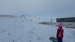
This is a great sledding hill. It's about the perfect steepness and really wide. It's also big enough to make it worth a little run on a snowboard or an inner tube. While this is a pretty popular hill, it's pretty hard for it to get overcrowded.
In 2017, some houses were built at the bottom of the hill that make it a little less perfect but there's still plenty of hill for a good time. You just need to be respectful of the people's homes and the end of the slope. There's also a little winding rutted dirt road that comes down to the left of the hill that sometimes is a pretty great little run if the snow's just right.
More Information
Add Resource- Plan Ahead and Prepare
- Travel & camp on durable surfaces
- Dispose of waste properly
- Leave what you find
- Minimize campfire impacts
- Respect wildlife
- Be considerate of other visitors
Directions
From Rexburg, Idaho
- Head south on S 3rd W toward W 2nd S (0.4 mi)
- Turn left onto W 4th S (0.1 mi)
- At the traffic circle, take the 1st exit onto S 2nd W (0.4 mi)
- Turn left onto W 7th S (0.6 mi)
- Turn right onto S 2nd E (0.5 mi)
- Turn left onto Sunrise Dr (0.2 mi)
- Sunrise Dr turns right and becomes Washington Blvd (384 ft)
- Turn right onto Jefferson Dr (466 ft)
- Jefferson Dr turns left and becomes Stone DrDestination will be on the left(0.2 mi)
This hill is back behind the water tower in Founder's Village. To get there, you'll go up past the temple and take the first left. That'll take you into Founders Village. Once you're in the village, just keep right until you get to the hill. It'll be straight in front of you after you pass underneath the water tower.
endovereric
12/18/16 10:22 amendovereric
12/28/17 11:03 am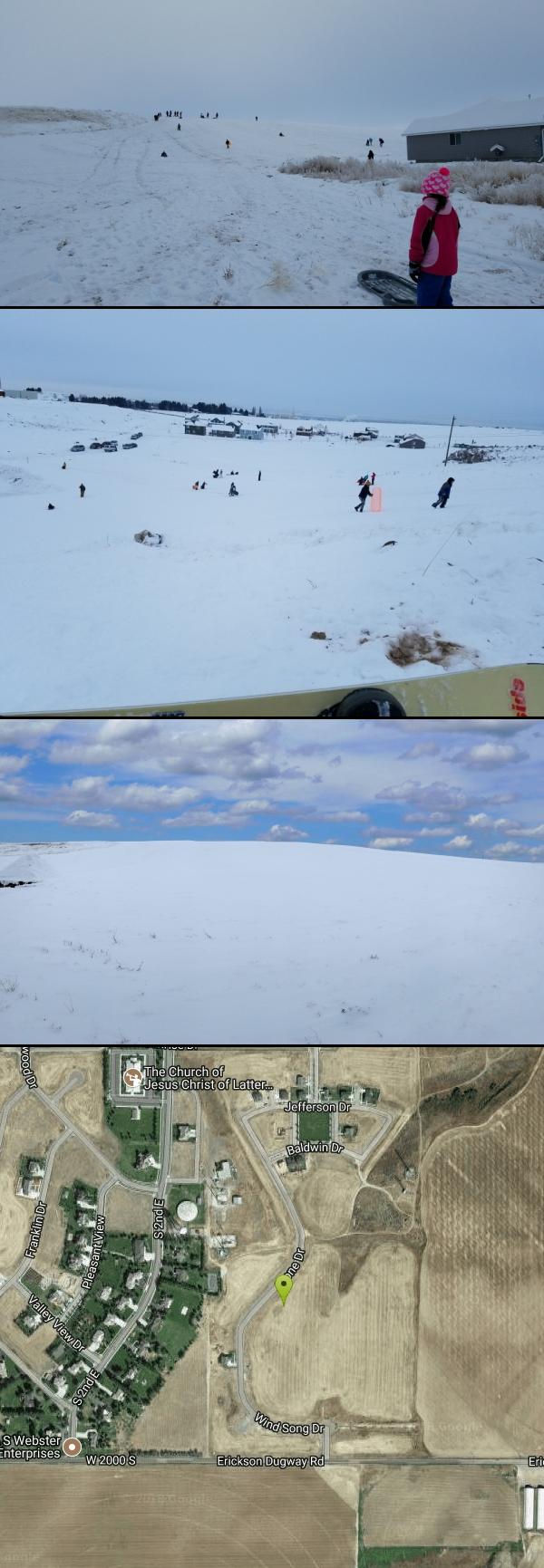


Other Sledding Hills Nearby
Hidden Valley Park
Rexburg, Idaho
1.8 miles NSled near Rexburg, Idaho
Sled
Smith Park
Rexburg, Idaho
1.8 miles NCity snow piled into a 30–40-foot sledding hill with a utility-box jump ramp makes Smith Park a beloved winter escape for kids in Rexburg.
Sled 0.4-0.7 mi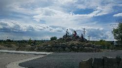
Rexburg Bike Park
Rexburg, Idaho
2.3 miles NA beginner-friendly bike park behind Rexburg Rapids with mounts in small, medium, and large sizes — and the same hills turn into great sledding terrain when snow arrives in winter.
Mountain Bike, Sled 0.2-0.5 mi
Eagle Park
Rexburg, Idaho
2.7 miles NA cottonwood forest park inside Rexburg city limits with campsites, fishing, a dog park, mountain biking on easy and moderate loops, and rock-throwing by the river.
Camp, Hike, Mountain Bike, Sled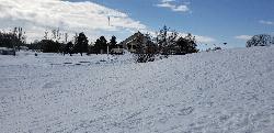
Teton Lakes Golf Course
Rexburg, Idaho
3.5 miles NWA year-round golf course that transforms into a free cross-country ski destination in winter, with over two miles of groomed set and skate tracks — plus the community Cupid Cup XC race each season.
Cross-country Ski, Sled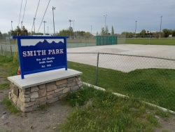
Smith Park
Sugar City, Idaho
5.0 miles NSugar Hill is a smaller sledding hill in Sugar City's Smith Park. It's great for younger kids or just some quick runs. You can often get a good run on every side.
Skateboard, Sled
Park on Center St
Sugar City, Idaho
5.2 miles NSled near Sugar City, Idaho
Sled
Jefferson County Lake (AKA Rigby Lake)
Rigby, Idaho
9.4 miles SWSandy beaches, two floating docks with a slide, volleyball, playgrounds, and a safe swim zone — Jefferson County Lake is eastern Idaho's go-to summer swimming spot.
Camp, Canoe, Dive, Kayak, Sled, Swim
Egin Lakes
Saint Anthony, Idaho
12.1 miles NUnusually shallow, sandy lakes on the gateway to the St. Anthony Sand Dunes — great for water games in 2-to-3-foot-deep water, the closest thing to a real beach in SE Idaho.
Sled, Swim
St. Anthony Sand Dunes
Saint Anthony, Idaho
14.7 miles NWinter transforms the St. Anthony Sand Dunes into the smoothest sledding surface around — hills in every direction, bowl features, and halfpipe-like terrain on mountains of snow-covered sand.
Sled
Ucon Pit
Idaho Falls, Idaho
17.3 miles SWThis is a great set of hills. The hills are big. There's almost no obstacles. With hills on every side, it's almost impossible to find this place over crowded.
Sled 0.3-0.6 mi
Bear Gulch
Ashton, Idaho
34.3 miles NEAn abandoned ski hill from 1969 with overgrown runs that still deliver great sledding — the lower run is fast and winding all the way down to the old ski lift.
Camp, Cross-country Ski, Hike, SledNearby Campsites
Eagle Park
Rexburg, Idaho
2.7 miles NA cottonwood forest park inside Rexburg city limits with campsites, fishing, a dog park, mountain biking on easy and moderate loops, and rock-throwing by the river.
Camp, Hike, Mountain Bike, Sled 0.8-1.3 mi
Warm Slough Campground
Rexburg, Idaho
6.7 miles NWA popular river campground with two boat ramps and an easy, slow-moving inner tube float — the take-out is 1,000 feet from the put-in, making multiple runs a breeze.
Airsoft, Camp, Canoe
Beaver Dick Park
Rexburg, Idaho
6.7 miles WA 9.5-acre Snake River park near Rexburg with fire pits, pavilions, fishing, boating, swimming, and a rich history tied to legendary frontiersman Beaver Dick Leigh.
Camp, Canoe, Disc Golf, Swim
Twin Bridges Park
Rexburg, Idaho
8.8 miles SA 27-acre Snake River park between two bridges near Rexburg with shaded campsites, fire pits, pavilions, a playground, and BLM ground for hiking and hunting on three sides.
Camp, Canoe
Jefferson County Lake (AKA Rigby Lake)
Rigby, Idaho
9.4 miles SWSandy beaches, two floating docks with a slide, volleyball, playgrounds, and a safe swim zone — Jefferson County Lake is eastern Idaho's go-to summer swimming spot.
Camp, Canoe, Dive, Kayak, Sled, Swim 0.6-2.0 mi
North Menan Butte ('R' Mountain)
Menan, Idaho
10.7 miles WA volcanic butte locals call R Mountain, with a paved trailhead, chain handrails near the top, informational signs at the rim, and views of Rexburg and the Snake River.
Camp, Cave, Hike 0.5-3.5 mi
Webster's Dam
Ririe, Idaho
11.4 miles SEAn abandoned dam in Moody Creek canyon where sediment split the stream into two beautiful 15-foot waterfalls — stunning in spring runoff and blazing with fall colors.
Camp, Hike, Mountain Bike
Big Hole Dispersed Campsites
Ririe, Idaho
12.2 miles SEA network of dispersed campsites with fire rings in the Big Hole mountains above Kelly Canyon — first come, first served, no reservations, and Leave No Trace principles are essential.
Camp
Paramount Wall / Blanche Rock
Ririe, Idaho
12.7 miles SEA sport climbing wall above the road near Ririe with great exposure, afternoon shade, and well-loved 5.9–5.10 lines — most routes work with a 50-meter rope, established by Chuck Oddette and crew.
Camp, Horseback, Rock Climb
Kelly Island Campground
Ririe, Idaho
13.4 miles SEA BLM campground with 14 family sites and 1 group site for RVs or tents, open May through September — vault toilets, pets welcome, and rates from $5–$20 per night.
Camp
Table Rock Campground
Ririe, Idaho
15.0 miles SEA campground in Caribou-Targhee National Forest — part of a 3-million-acre stretch from Montana to the Utah and Wyoming borders — with access to the Curlew National Grassland.
Camp
Wolf Flats Recreation Area
Ririe, Idaho
16.2 miles SEWolf Flats is a completely free, dispersed, undeveloped camping area with 25 locations to camp. Some areas are large enough to accommodate groups of 50 people.
Camp
Moody Meadows
Driggs, Idaho
17.6 miles SEGood place for kids, they can ride bikes in the meadow, play in the stream, and camping is off of the road. Hiking, motorbiking, and horseback riding trails are abundant in the area.
Camp
Sealander Park
Idaho Falls, Idaho
31.7 miles SWA peaceful 15-acre park steeped in Idaho homesteader history — listed on the National Register of Historic Places, Sealander Park is available to reserve for picnics, reunions, weddings, and retreats.
Camp
Fall Creek Falls
Swan Valley, Idaho
31.9 miles SEA shaded Snake River campground near Swan Valley with abundant wildlife, great trout fishing, and Fall Creek Falls a quarter-mile away.
Camp, Cave, Hike, Kayak, Swim
Warm River Campground
Ashton, Idaho
32.1 miles NESlow-moving warm water and willow-lined banks make this campground a perfect spot for tubing, trout fishing, and peaceful mountain biking at 5,200 ft elevation.
Camp
Pine Butte / The Caldera
St. Anthony, Idaho
32.2 miles NAn old volcano in the Idaho desert that feels like stepping into a mountain forest — pine-covered hillsides, a meadow ringed by aspen and boulders, and a quarter-mile easy trail to the caldera floor.
Camp, Hike, Horseback
Pine Creek Campground
Victor, Idaho
32.6 miles SEThe Pine Creek Campground has 10 single units and has restrooms.
Camp
Falls Campground
Victor, Idaho
32.8 miles SEA Snake River campground near Swan Valley with cottonwood shade, abundant wildlife — eagles, osprey, moose, and deer — and Fall Creek Falls just a quarter mile away; Palisades Reservoir is 20 miles out.
Camp
Porcupine Creek
Ashton, Idaho
34.0 miles NEA backcountry hunting, fishing, camping, and swimming spot in Targhee National Forest, surrounded by forests, meadows, a creek, and unmarked trails — bear country, so pack and store food carefully.
Camp, Swim


