


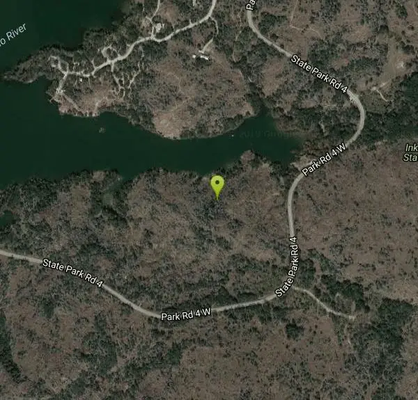
Devils Water Hole
Burnet, Texas

| GPS: |
30°43'58.2"N 98°22'22.6"W Maps | Directions |
| State: | Texas |
| Trails/Routes: | 0.1 mi |
Restrooms Picnic Tables Lakes Rivers Waterfalls Trails Rocks State Park
Hike and Swim
Devil's Waterhole is a canyon swimming hole located in Inks Lake State Park. This beautiful reservoir is a part of the Colorado River and takes a hike to find, but once you arrive the beauty will be well worth it. Devil's Waterhole is surrounded beautiful rock formations and woods where hiking trails are available and diving spots can be found. The water is calm, deep and cool the perfect place to bring your floaties and enjoy a relaxing day on the water.
Because of the rocky terrain swim shoes are recommended to protect feet from injury. No lifeguards are posted at this swimming hole, so swimming and diving are at your own risk. It is recommended to swim in groups and only dive with experience in areas with deeper water. Parking is available in several places throughout the park, but the nearest parking lot fills up quickly. The earlier you arrive the easier it will be to find a spot.
Inks Lake State Park is open from 8:00 am to 10:00 pm daily and costs $6.00 for a day pass (children 12 and under enter for free). The day pass includes other areas and activities at Inks Lake State Park as well as the cost for parking. Reservations are required for Devil's Waterhole and can be made on the state park website or by calling their costumer service center.
More Information
Be courteous, informed, and prepared. Read trailhead guidelines, stay on the trail, and don't feed the wildlife.
Read More- Plan Ahead and Prepare
- Travel & camp on durable surfaces
- Dispose of waste properly
- Leave what you find
- Minimize campfire impacts
- Respect wildlife
- Be considerate of other visitors
Directions
From Burnet, Texas
- Head west on W Polk St/
E State Hwy 29 toward S Water St Continue to follow W Polk St(0.3 mi) - Continue onto TX-29 W/
Buchanan Dr Continue to follow TX-29 W(8.8 mi) - Turn left onto Park Rd 4 W/
State Park Rd 4 (3.2 mi) - Turn right onto State Hwy Park Rd 4Partial restricted usage road(0.2 mi)
- Turn leftRestricted usage road(0.7 mi)
- Turn leftRestricted usage road(0.1 mi)
The park is located 9 miles west of Burnet. Take State Highway 29 to Park Road 4. Go south 3 miles to the park headquarters.


Trails
Distance ?
744 feetElevation Gain ?
-17 feetReal Ascent ?
18 feetReal Descent ?
35 feetAvg Grade (-1°)
-2%Grade (-7° to 8°)
-11% to 15%Elevation differences are scaled for emphasis. While the numbers are accurate, the cut-away shown here is not to scale.
Other Swimming Holes and Hiking Trails Nearby

Llano Slab
Kingsland, Texas
7.5 miles SWLlano Slab is a public swimming hole on the Llano River. Here the river is slow moving and separated into several pools of varying depth by unique granite formations.The variety in the pools make...
Swim
Krause Springs
Spicewood, Texas
22.0 miles SECamp and Swim near Spicewood, Texas
Camp, Swim
Colorado Bend State Park
San Saba, Texas
23.9 miles NColorado Bend State Park is a beautiful destination with 6 miles of Colorado River front and 35 miles of hiking and biking trails. This lush park offers a variety of activities to its visitors...
Camp, Hike, Kayak, Mountain Bike, Swim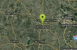
Hancock Springs Pool
Lampasas, Texas
24.9 miles NESulfurous apring used to be health resort now a spring fed town pool. Fees: Yes, see web site
Swim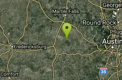
Pedernales Area
Perryton, Texas
28.1 miles SSwim near Perryton, Texas
Swim
Pedernales Falls
Johnson City, Texas
28.5 miles SPedernales Falls is a tranquil swimming hole in the beautiful Pendernales Falls State Park. The park is known for the stunning limestone formations and waterfalls created by the Padernales...
Camp, Hike, Horseback, Mountain Bike, Swim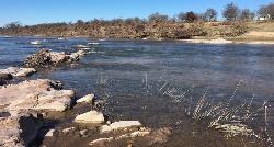
Castell Crossing
Llano, Texas
34.7 miles WCastell Crossing is a 950 foot stretch of riverfront on the Llano River that is open from 30 minutes before sunset to 30 minutes after sunset. This is the perfect place to spend the day...
Canoe, Kayak, Swim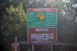
Hippie Hollow Park
Austin, Texas
36.6 miles SESituated on 109 peaceful acres, Hippie Hollow is a clothing optional park securely nestled in the natural beauty of the Hill County of Lake Travis, only 20 minutes off Interstate 35, but a world...
Swim 0.4-0.9 mi
Wild Basin Wilderness Preserve
Austin, Texas
43.9 miles SEThis trail and preserve is a great place to hike and explore nature. You can get a guided tour, which allows for a more educational experience, or you can take your time to just enjoy the scenery and...
Hike
Blanco State Park
Blanco, Texas
44.6 miles SBlanco State Park is a unique little park on the Blanco River. This spring fed swimming hole is created by a multi level rectangular damn in the River. The water cascades over the unique angles...
Camp, Canoe, Hike, Kayak, Swim
Hill Of Life
Austin, Texas
45.5 miles SEHike and Swim near Austin, Texas
Hike, Swim 0.2 mi
Mayfield Nature Preserve
Austin, Texas
46.1 miles SEMayfield has so many great trails. There are a couple of loops you could travel that leads you to other trails, and will take you on many adventures around the preserve. Please...
Hike
Sculpture Falls
Austin, Texas
46.2 miles SEHike and Swim near Austin, Texas
Hike, Swim 1.2 mi
Barton Creek Greenbelt
Austin, Texas
47.4 miles SEThis hike can be up to 7.9 miles long and starts up near Zilker Park. You can choose the length of your hike, walk, or run. The easiest access to the Greenbelt, though, is through the Loop 360...
Hike
Twin Falls
Austin, Texas
47.4 miles SEHike and Swim near Austin, Texas
Hike, Swim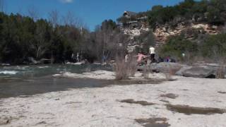
Campbell's Hole, Austin, TX, USA
Austin, Texas
47.9 miles SEHike and Swim near Austin, Texas
Hike, Swim
Zilker Park
Austin, Texas
48.2 miles SEHike and Swim near Austin, Texas
Hike, Swim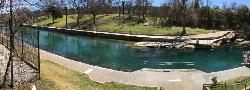
Barton Springs Pool
Austin, Texas
48.4 miles SEWithin Zilker Park's 358 acres lies one of the crown jewels of Austin - Barton Springs Pool. The pool itself measures three acres in size, and is fed from underground springs with an average...
SwimNearby Campsites
Krause Springs
Spicewood, Texas
22.0 miles SECamp and Swim near Spicewood, Texas
Camp, Swim
Colorado Bend State Park
San Saba, Texas
23.9 miles NColorado Bend State Park is a beautiful destination with 6 miles of Colorado River front and 35 miles of hiking and biking trails. This lush park offers a variety of activities to its visitors...
Camp, Hike, Kayak, Mountain Bike, Swim
Pedernales Falls
Johnson City, Texas
28.5 miles SPedernales Falls is a tranquil swimming hole in the beautiful Pendernales Falls State Park. The park is known for the stunning limestone formations and waterfalls created by the Padernales...
Camp, Hike, Horseback, Mountain Bike, Swim
Blanco State Park
Blanco, Texas
44.6 miles SBlanco State Park is a unique little park on the Blanco River. This spring fed swimming hole is created by a multi level rectangular damn in the River. The water cascades over the unique angles...
Camp, Canoe, Hike, Kayak, Swim


