


Harry Harm Park
Bigfork, Montana
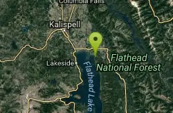
Hike
More Information
Add ResourceBe courteous, informed, and prepared. Read trailhead guidelines, stay on the trail, and don't feed the wildlife.
Read More- Plan Ahead and Prepare
- Travel & camp on durable surfaces
- Dispose of waste properly
- Leave what you find
- Minimize campfire impacts
- Respect wildlife
- Be considerate of other visitors
Directions
From Bigfork, Montana
- Head north toward Monroe St (144 ft)
- Turn left at the 1st cross street onto Monroe St (338 ft)
- Monroe St turns right and becomes Chickadee Ln (348 ft)
- Turn left onto Commerce St (0.3 mi)
- Turn left onto Grand Ave (128 ft)
- Turn right onto Holt Dr (269 ft)
- Turn left onto MT-35 E (0.8 mi)
- Turn right onto Harry Horn Rd (449 ft)
- Turn left (200 ft)

Other Hiking Trails Nearby

Jewel Basin
Kalispell, Montana
10.6 miles NEBeautiful hiking area in the Montana wilderness, Jewel Basin is home to lakes with plenty of fish, and many peaks to ascend.
Backpack, Camp, Hike 4.5 mi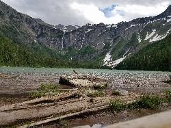
Avalanche Lake
Apgar Village, Glacier National Park
44.7 miles NHike near Apgar Village, Glacier National Park
Hike 0.9 mi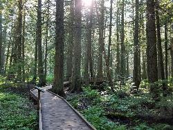
Trail of the Cedars
Apgar Village, Glacier National Park
44.8 miles NThe Trail of the Cedars is one of the most popular hikes in the park because of it offers great views without too much exertion. It is a short loop hike around Avalanche Creek in Glacier...
Hike 5.0 mi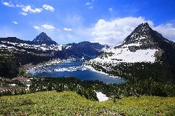
Hidden Lake
Glacier National Park
47.2 miles NThe Hidden Lake Trail in Glacier National Park is a moderate to strenuous hike that offers breathtaking views of the surrounding landscape. Located in the northwest region of Montana, the park is...
Hike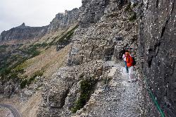
Highline Trail
Logan Pass, Glacier National Park
47.2 miles NOne of the most popular hikes in Glacier National Park. The Highline Trail is on many people's hiking lists because it showcases all of the beauty of Glacier National Park in just one hike. This...
Backpack, Hike
Clements Mountain Trail
Logan Pass, Glacier National Park
47.3 miles NLocated in Glacier National Park, Clements Mountain is a four mile round trip hike. Clements Mountain is often mistaken for Reynolds Mountain, both of which can be seen from the Logan Pass...
Backpack, Camp, Hike, Rock Climb 1.4-4.6 mi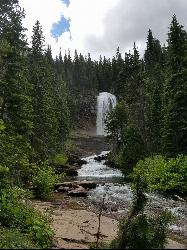
St Mary and Virginia Falls
Rising Sun, Glacier National Park
47.8 miles NEVirginia Falls is one of two major waterfalls that feed into St Mary Lake. The trail is about 3.7 miles roundtrip, where visitors will see other waterfalls such as St Mary waterfall. The trail begins...
Hike 0.6 mi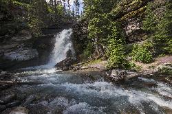
Baring Falls
Glacier National Park
48.3 miles NEThe Baring Falls are named after the Baring Creek, which flows into the Middle Fork of the Flathead River. The falls themselves are a stunning sight to behold, with a 30-foot drop into a pool of...
Hike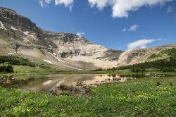
Siyeh Pass Trail
Logan Pass, Glacier National Park
48.4 miles NELIke many of the trails found throughout Glacier National Park, Siyeh Pass trail takes hikers through beautiful meadows and forests, complete with top-of-the-world views. The trail begins at Siyeh...
Backpack, HikeNearby Campsites
Jewel Basin
Kalispell, Montana
10.6 miles NEBeautiful hiking area in the Montana wilderness, Jewel Basin is home to lakes with plenty of fish, and many peaks to ascend.
Backpack, Camp, Hike
Apgar Campground
Apgar Village, Glacier National Park
32.8 miles NApgar Campground is a beautiful campsite located in the heart of Glacier National Park in Montana. Situated on the shores of Lake McDonald, this campground offers stunning views of the surrounding...
Camp
Fish Creek Campground
Glacier National Park
34.3 miles NFish Creek Campground is a popular campsite located within Glacier National Park in Montana. It offers a peaceful and picturesque setting for travelers looking to experience the beauty of the...
Camp
Sprague Campground
Glacier National Park
39.1 miles NSprague Campground is a popular destination for travelers visiting Glacier National Park in Montana. Located on the west side of the park, the campground is named after Amos Sprague, one of the first...
Camp
Two Medicine Campground
Glacier National Park
44.4 miles NECamp near Glacier National Park
Camp
Avalanche Campground
Glacier National Park
44.7 miles NAvalanche Campground is a popular destination for visitors to Glacier National Park in Montana. Located on the western side of the park, the campground is just a short drive from the Apgar Visitor...
Camp
Logging Creek Campground
Glacier National Park
44.8 miles NLogging Creek Campground is a popular camping destination located in the beautiful Glacier National Park in Montana. With its stunning mountain views and close proximity to a variety of outdoor...
Camp
Quartz Creek Campground
Glacier National Park
46.7 miles NQuartz Creek Campground is a popular destination for campers visiting Glacier National Park in Montana. Located in the heart of the park, this campground offers a peaceful and serene setting for...
Camp
Clements Mountain Trail
Logan Pass, Glacier National Park
47.3 miles NLocated in Glacier National Park, Clements Mountain is a four mile round trip hike. Clements Mountain is often mistaken for Reynolds Mountain, both of which can be seen from the Logan Pass...
Backpack, Camp, Hike, Rock Climb
Cut Bank Campground
Glacier National Park
49.3 miles NENestled in a beautiful forested setting along the Cut Bank Creek, Cut Bank Campground offers a peaceful and serene atmosphere for campers to enjoy. The campground has a total of 48 campsites, all...
Camp


