


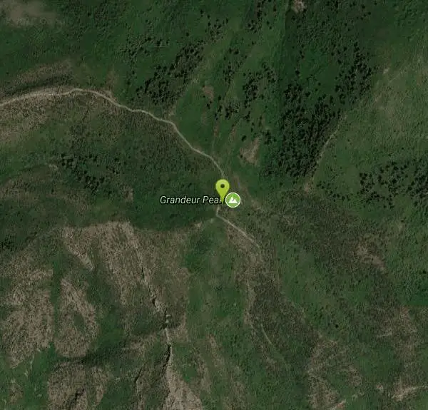
Grandeur Peak
Salt Lake City, Utah

Hike
Grandeur Peak is the most easily accessible of the major peaks that form the Salt Lake City skyline. For many valley residents Grandeur Peak was there first major summit. The peak offers great views of the valley and year round access to hikers of all abilities.
More Information
Add ResourceBe courteous, informed, and prepared. Read trailhead guidelines, stay on the trail, and don't feed the wildlife.
Read More- Plan Ahead and Prepare
- Travel & camp on durable surfaces
- Dispose of waste properly
- Leave what you find
- Minimize campfire impacts
- Respect wildlife
- Be considerate of other visitors
Directions
From Salt Lake City, Utah
- Head west on 400 S/University Blvd toward Main St (0.2 mi)
- Turn left at the 1st cross street onto W Temple (0.2 mi)
- Turn right onto 500 S/Cesar E. Chavez Blvd (0.6 mi)
- Take the I-80 E/I-80 W ramp on the left to Cheyenne/Reno/S.L. International Airport/Las Vegas (0.2 mi)
- Keep left at the fork, follow signs for I-15 S/I-80 E/Cheyenne/Las Vegas and merge onto I-15 S/I-80 E (2.5 mi)
- Keep right at the fork to continue on I-80 E, follow signs for Cheyenne/Interstate 80 (5.0 mi)
- Take exit 128 for Interstate 215 S/Belt Route (1.2 mi)
- Continue onto I-215 S/Belt Route (1.4 mi)
- Take exit 4 for 3900 S toward Hospital (0.2 mi)
- Turn left onto 3900 S (0.1 mi)
- Turn left onto Wasatch Blvd (0.1 mi)
- Turn right at the 1st cross street onto 3800 S/Millcreek Canyon RdContinue to follow Millcreek Canyon Rd(2.2 mi)
From the end of Wasatch Boulevard walk up the dirt road and take the first right fork. The dirt road heads towards the mountain. To the left (north) is the first ridge from Parleys Canyon. In the gully formed by the first and second ridge south of Parleys Canyon, there is a well-maintained trail leading up the bottom of the gully. This is the best route for climbing the West Ridge. The trail follows the gully and than cuts left to the ridge top and a view of Parleys Canyon. From the Parleys Canyon viewpoint the route is a well-used hiker made trail which follows the steep ridge to the summit.
Other Hiking Trails Nearby

Salt Lake Valley Scenic Overlook
Salt Lake City, Utah
1.1 miles SThe Salt Lake Valley Scenic overlook starts on the Desolation trail in Millcreek Canyon near Salt Lake City, Utah and offers hikers a wide variety of destinations to stop at along the trail,...
Hike
Pete's Rock
Salt Lake City, Utah
4.5 miles SWA large rock next to the Mount Olympus trailhead known locally as Pete's Rock and is a popular place for casual rock climbing. Mount Olympus is a prominent 9,026 feet peak on the east side of the...
Hike, Rock Climb
Hidden Falls
Salt Lake City, Utah
5.3 miles SHidden Falls is a popular road side attraction for anyone cruising Big Cottonwood Canyon on a sunny afternoon. The falls are within strolling distance of the parking lot and only require about 15...
Hike
Storm Mountain
Salt Lake City, Utah
5.8 miles SStorm Mountain is on of the smaller peaks included in the Wasatch Range. Storm Mountain is located in Cottonwood Canyon. Storm Mountain Day Use Area is just 3 miles up Big Cottonwood Canyon,...
Hike, Mountain Bike, Rock Climb
Ferguson Canyon
Cottonwood Heights, Utah
6.8 miles SFerguson canyon is small canyon between Big and Little Cottonwood Canyons. This canyon has gained popularity over the last few year and is a popular destination for rock climbers. This is one hike...
Hike, Mountain Bike, Rock Climb
Donut Falls
Salt Lake City, Utah
7.1 miles SEVery popular beginning hike in the Salt Lake City area. Many take this as a good intro hike into the outdoors, while others go for a trip out with friends to escape the rush of daily life. The...
Hike, Swim
Lake Blanche
Salt Lake City, Utah
7.8 miles SELake Blanche is a fun and popular hike. Lake Blanche, Lake Florence and Lake Lillian are all located next to each other in the upper reaches of the South Fork of Mill B. The trail to Lake Blanche...
Hike 4.7 mi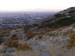
Bonneville Shoreline Trail
Salt Lake City, Utah
8.5 miles NWBonneville Shoreline Trail is a great place for hiking, biking, and trail running. It stretches from North Salt Lake to Parley's Canyon. The trail follows the shoreline of ancient Lake...
Hike, Mountain Bike 0.7 mi
Great White Icicle
Sandy, Utah
9.4 miles SThe Great White Icicle is located in Little Cottonwood Canyon just outside of Salt Lake City, Utah. It is a climbing area that is a frozen waterfall in the winter and a cascading waterfall...
Hike, Rock Climb
Lisa Falls
Sandy, Utah
9.4 miles SLisa Falls is a great place to climb Spring through Fall, any time of day. The base is well shaded by trees and offers many flat places to belay, or just hang out and relax. The roaring waterfall...
Hike, Rock Climb
Pfeiferhorn Peak
Provo, Utah
10.0 miles SEThe Pfeifferhorn is a majestic peak, which is located east of Salt Lake City, Utah in the Wasatch mountain range. It's easy access, proximity to alpine lakes and short trail make it a popular...
Backpack, Hike 1.1-4.7 mi
Bells Canyon
Sandy, Utah
10.1 miles SBells Canyon is a moderate, 4.5 mile hike that begins in a residential area and ends at a waterfall in the enter of the canyon's forest. The first 1/2 mile of the hike is relatively...
Backpack, Hike, Mountain Bike, Snowshoe 0.2 mi
Rocky Mouth Trail/Waterfalls
Sandy, Utah
11.3 miles SThis adventure begins with a very scenic hike to a beautiful waterfall and ends with a magnificent rappel through a short slot canyon and down the waterfall. The hike to the waterfall is a great trip...
Canyoneer, Hike, Rock Climb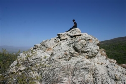
Mueller Park Trail
Bountiful, Utah
11.6 miles NThe Mueller Park Trail is a great year-round trail that's almost right off the road. It's considered moderate difficulty. It's a gradual grade with beautiful views. It's a popular...
Cross-country Ski, Hike, Mountain Bike
Silver Lake (Big Cottonwood)
Brighton, Utah
11.7 miles SEThis hike has everything. The trail passes by three bodies of water and winds through beautiful woodland areas. Wildlife is in abundance. Everything from chipmunks to moose can be observed along...
Hike, Mountain Bike 0.4 mi
Hidden Valley Park trail
Sandy, Utah
11.8 miles SHidden Valley Trail has different levels and gradual uphill fun and makes for a good adventure trail. It's a wide, shallow valley that is hidden from view; hence the name. The valley’s...
Hike, Mountain Bike
Cecret (Secret) Lake
Alta, Utah
11.9 miles SECecret (pronounced "Secret") Lake is a beautiful lake located among alpine meadows in Little Cottonwood Canyons Albion Basin. Some folks spell Secret Lake as Cecret Lake, but the USGS...
Hike
American Fork Twin Peaks
Provo, Utah
12.0 miles SEAmerican Fork Twin Peaks is the highest mountain on the Little Cottonwood Canyon ridge. The summit is the prominent peak overlooking the Snowbird ski resort. A short approach hike...
Hike
Sugarloaf Peak
Alta, Utah
12.1 miles SESugarloaf Peak is an easily reached 11,000 ft. summit which overlooks Albion Basin, Secret Lake, and much of Utah's Alta ski resort. The easy terrain and relatively high trailhead elevation...
Hike
White Pine Lake
Sandy, Utah
12.2 miles SWhite Pine Canyon has long been the subject of intense controversy between advocates of wilderness and ski resort owners. The original boundaries of Lone Peak Wilderness Area, created in 1977, were...
Hike, Mountain BikeNearby Campsites

Mill Creek Canyon
Salt Lake City, Utah
2.5 miles EMill Creek is an out and back with over 1000 ft of elevation gain. The lower section of the ski trail gets a lot of foot traffic, but the upper section (above Elbow Fork) is generally very quiet....
Camp, Cross-country Ski, Snowshoe
Spruces Campground
Salt Lake City, Utah
7.8 miles SECamping isn't free. See USDA.gov for details. If you know the coordinates of the sledding hill here, please comment.
Camp, Sled
Holbrook Trailhead
Bountiful, Utah
12.8 miles Nairsoft feaild woth bunkers
Airsoft, Backpack, Camp, Paintball, Snowshoe 1.6-14.1 mi
Mount Timpanogas
Provo, Utah
20.1 miles SMt. Timp, as the locals call it, is the 2nd highest mountain in the Wasatch range (only Mt. Nebo is higher). What sets "Timp" apart is its location. It towers over the Provo, Orem, Pleasant...
Camp, Hike, Horseback, Swim
Y-Mountain Summit Trail
Provo, Utah
32.9 miles SY Mountain is located directly east of Brigham Young University (BYU) in Provo, Utah, United States. The Slide Canyon/Y Mountain Trail leads to a large block Y located 1.2 miles (1.9 km) from a...
Camp, Hike 5.6 mi
Antelope Island Lakeside Trail
Syracuse, Utah
33.2 miles NWThe Lakeside Trail is a kid-friendly trail with great views and many bugs. This is a gorgeous scenic hike winding around part of the Great Salt Lake. The trail on Antelope Island that runs about...
Camp, Hike, Horseback
Antelope Island State Park
Syracuse, Utah
33.4 miles NWLocated just 41 miles north of Salt Lake City, Antelope Island State Park encompasses a vast selection of outdoor activities and spectacular scenery providing a peaceful nature experience. Experience...
Backpack, Camp, Hike, Horseback, Mountain Bike 2.9 mi
Pineview Reservoir
Eden, Utah
40.9 miles NLocated on the backside of the Wasatch Front, Pineview Reservoir in the Ogden River Canyon is home to stunning views of the water, sandy beaches, the Southern Skyline trail, paved ramps, and...
Camp, Canoe, Hike, Kayak, Mountain Bike, Swim 4.7 mi
Fifth Water Hot Springs
Provo, Utah
48.0 miles SEAKA Diamond Fork Hot Springs A beautiful drive and a 2.5 mile hike along the river will end you at an amazing set of hot springs that's well worth the trip. There's a variety of...
Backpack, Camp, Hike, Hot Springs, Mountain Bike, Swim
Hell Hole Lake
Evanston, Utah
48.3 miles EThe first 250 feet of this trail are on private property with access provided by Kayenta. The trail is actually the northern portion of Dry Wash. Sand and boulders litter the wash making hiking...
Camp, Hike, Horseback


