


Map of 857 Hiking Trails in United States
first prev 1 2 3 4 5 6 7 8 9 10 next lastShowing Hiking Trails in United States City, Zip, or Address
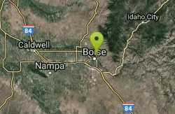
Central Foothills
Boise, Idaho
1.3 miles NE of Boise, IdahoFrom foothills to mountain tops, Idaho's wilderness offers some of the best hiking in the country. With over 19,000 miles of trails, hikers can find everything from paved recreational trails...
Hike, Mountain Bike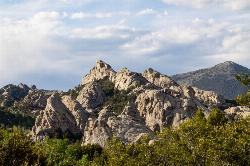
City of Rocks National Reserve
Malta, Idaho
23.3 miles SW of Malta, IdahoThe City of Rocks, or "The City" as locals call it, is one of the best places in the country to go rock climbing. Throughout the valley granite spires dominate the skyline, reaching...
Camp, Hike, Horseback, Mountain Bike, Rock Climb
Hidden Falls
Salt Lake City, Utah
12.3 miles SE of Salt Lake City, UtahHidden Falls is a popular road side attraction for anyone cruising Big Cottonwood Canyon on a sunny afternoon. The falls are within strolling distance of the parking lot and only require about 15...
Hike 3.2-47.0 mi
Yellowstone Branch Line Trail
Ashton, Idaho
7.6 miles NE of Ashton, IdahoYellowstone branch line trail runs from Warm River to the Montana border totaling 39 miles. There are a few places to jump on and off the trail as well as a few smaller trails that branch off of this...
Backpack, Cross-country Ski, Hike, Horseback, Mountain Bike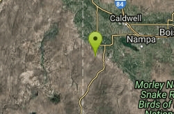
Jump Creek
Marsing, Idaho
7.1 miles SW of Marsing, IdahoA surprising waterfall and lush riparian community filled with waterbirch and red osier dogwood trees. Visitors can hike the easy ¼ mile Jump Creek Falls Trail - you may get your feel wet!...
Canyoneer, Hike, Rock Climb, Swim 13.2-13.5 mi
Bear Creek Hot Springs
Irwin, Idaho
9.8 miles S of Irwin, IdahoBear Creek Hot Springs is a 15 mile out and back trail with a hot spring at the end. The trail is not well marked and is only recommended for very experienced outdoorsmen and primarily used for...
Backpack, Camp, Hike, Horseback, Hot Springs, Mountain Bike
Pine Butte / The Caldera
St. Anthony, Idaho
21.7 miles N of St. Anthony, IdahoThis is about as close to an oasis as you can get in the deserts of Idaho. It's an old volcano in the middle of the sagebrush desert. As soon as you start down the path, you can feel the air...
Camp, Hike, Horseback
Y-Mountain Summit Trail
Provo, Utah
2.8 miles E of Provo, UtahY Mountain is located directly east of Brigham Young University (BYU) in Provo, Utah, United States. The Slide Canyon/Y Mountain Trail leads to a large block Y located 1.2 miles (1.9 km) from a...
Camp, Hike 4.7 mi
Fifth Water Hot Springs
Provo, Utah
19.0 miles SE of Provo, UtahAKA Diamond Fork Hot Springs A beautiful drive and a 2.5 mile hike along the river will end you at an amazing set of hot springs that's well worth the trip. There's a variety of...
Backpack, Camp, Hike, Hot Springs, Mountain Bike, Swim 0.2 mi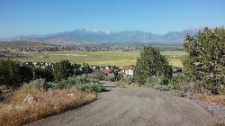
Kiowa Valley Path
Eagle Mountain, Utah
3.0 miles NE of Eagle Mountain, UtahAt 0.3 miles, this short little hike is almost more of a quick dog walk but kids seem to enjoy the lizards and rabbits that frequent the path. The lizards seem to enjoy basking in the heat of the...
Hike
Tom's Thumb Trail
Scottsdale, Arizona
15.6 miles NE of Scottsdale, ArizonaTom's Thumb Trail is a popular trail on the McDowell Sonoran Preserve due to its unique thumb-like granite rock formation. This is a 4.7 out-and-back, intermediate trail because of its 1,200...
Hike, Mountain Bike, Rock Climb 0.8 mi
Bear Canyon Suspension Bridge
Draper, Utah
1.6 miles E of Draper, UtahThe Bear Canyon Suspension Bridge is a 185ft bridge that connects the Bear Canyon to the Bonneville Shoreline Trail. The bridge was built and completed in 2015 thanks to donations from residents and...
Hike, Mountain Bike 2.0 mi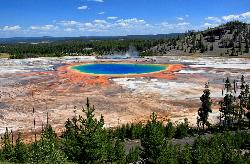
Grand Prismatic Spring Overlook Trail
Old Faithful, Yellowstone National Park
3.8 miles N of Old Faithful, Yellowstone National ParkThe Grand Prismatic Spring Overlook Trail gives hikers an opportunity to see the famous aerial view of the Grand Prismatic Spring. The vibrant rainbow waters of the Grand Prismatic Spring are...
Hike 0.6 mi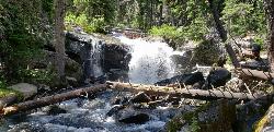
Pintler Falls
Wise River, Montana
23.8 miles W of Wise River, MontanaHike near Wise River, Montana
Hike 1.4 mi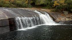
Turtleback Falls
Lake Toxaway, North Carolina
3.3 miles SW of Lake Toxaway, North CarolinaTurtleback Falls was named for its domed shape, similar to the back of a turtle. It's also called "umbrella falls" for the same reason. Visitors slide down Turtleback as the...
Backpack, Hike, Swim 7.6 mi
Mount Jefferson
Island Park, Idaho
9.7 miles N of Island Park, IdahoMount Jefferson, at 10, 203 feet is the highest point in the Centennial Mountains, a small, local range on the border of Idaho and Montana a little west of Yellowstone. These mountains consist of a...
Hike 1.7 mi
Buckskin Morgan Ridge
Ririe, Idaho
9.0 miles E of Ririe, IdahoCLOSED. This land is owned and managed by the US Forest Service and is not designated for use. As of July 2024, being caught mountain biking on this trail could recieve up to a $5000 fine and a...
Hike, Mountain Bike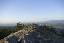
Spencer Butte
Eugene, Oregon
4.8 miles S of Eugene, OregonIn need of a nearby hiking fix? Spencer Butte is the perfect place to get away from the city of Eugene and into the forest. Spencer Butte is a prominent landmark in Lane County, Oregon. It is...
Hike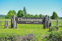
Champoeg State Park
Saint Paul, Oregon
4.9 miles NE of Saint Paul, OregonChampoeg State Park (commonly pronounced SHAM-poo-EE) is a historic pioneer site as well as a beautiful outdoor recreational area. The Native Americans originally pronounced it CHAM-po-EGG, but it...
Camp, Disc Golf, Hike, Mountain Bike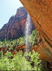
Emerald Pools Trail
Hurricane, Utah
19.0 miles E of Hurricane, UtahThe Emerald Pools were named for their unusual color. At some times of the year, algae gives the water in these pools a distinctive hue. A series of basins have been carved into a rock ledge in the...
Hike


