


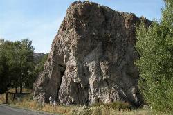
Paramount Wall / Blanche Rock
Ririe, Idaho

| Address: | 5451 Kelly Canyon Rd, Ririe, ID 83443, USA |
| GPS: |
43°38'19.7"N 111°39'10.4"W Maps | Directions |
| State: | Idaho |
Camp, Horseback, and Rock Climb
Sitting high above the road, the routes at Paramount offer great exposure and relief from the afternoon summer sun. Chuck Oddette, Steve Reiser and Jed Miller established the routes from 1989 to 1990. While not the hardest climbing around, Paramount is home to great lines in the 5.9 - 5.10 range a perfect place for the budding lead climber. All routes except Fly By Night, Positively Negative, and Spraypaint can be done with a 50-meter rope.
Courtesy of SEIClimbing.comMore Information
Add Resource- Plan Ahead and Prepare
- Travel & camp on durable surfaces
- Dispose of waste properly
- Leave what you find
- Minimize campfire impacts
- Respect wildlife
- Be considerate of other visitors
Directions
From Ririe, Idaho
- Head east on Smith St toward 1st E St (0.3 mi)
- Continue onto Archer Rd (1.6 mi)
- Turn right onto E 200 N/Heise Rd/Poplar Loop (0.9 mi)
- Slight right onto Heise Rd/Poplar Loop (0.2 mi)
- Continue straight onto N 4800 E/Heise Rd/Poplar LoopContinue to follow Heise Rd/Poplar Loop(2.9 mi)
- Slight left onto E 100 N/Heise Rd/Poplar Loop (187 ft)
- Slight left onto N 5050 E (0.4 mi)
- Turn right onto E Heise Rd (2.3 mi)
- Continue straight onto Kelly Canyon RdDestination will be on the left(1.0 mi)
From Idaho Falls drive east on Highway 26 for about 16 miles and turn left at the signs for Kelly Canyon Ski Hill and Heise Hot Springs – continue following the signs to the ski hill. At 3 miles, turn right after crossing the Snake River and continue past the hot springs. Just past the golf course, Heise Rock comes into view on the left. Continue on past Heise. Drive past the first cattle guard and follow the road as it turns left sharply and begins to climb – there is a small parking area to the left about 200 yards up the road. Follow the loose trail up to the base of the climbing area. You can also park further up the road to the left in the parking area of Little Kelly Canyon just before the second cattle guard.
Courtesy of SEIClimbing.com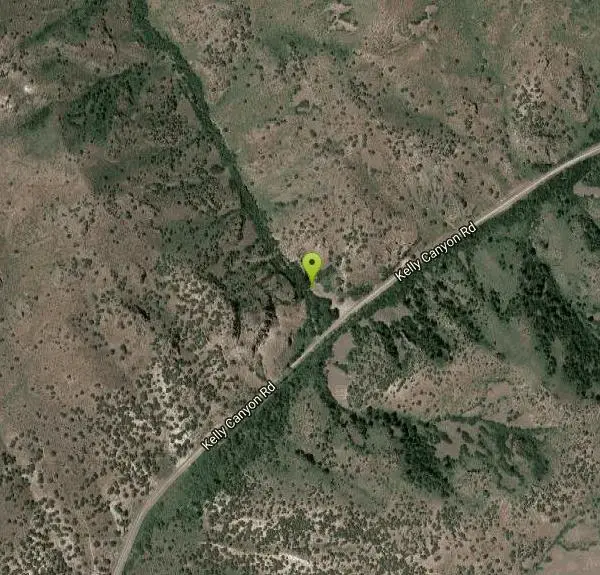

Other Rock Climbing Walls and Horseback Trails Nearby
Heise Rock (AKA Elephant Rock)
Ririe, Idaho
1.1 miles WCLOSED. Rock climbing is no longer permitted. This volcanic plug sits just off the road near the Heise Hot Springs Golf Course. It is also referred to as Elephant Rock or Chuck's Choss Pile. Aid...
Rock Climb 0.3 mi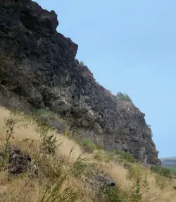
Pointless Crag
Ririe, Idaho
2.7 miles SNO MORE BOLTING as of 5/2012 requested by the Bureau of Land Management. The BLM has asked us NOT to park on the road below the cliff. Please use the obvious parking area next to the river...
Rock Climb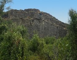
South Park
Ririe, Idaho
3.1 miles SRock Climb near Ririe, Idaho
Rock Climb
Blacktail Day Use Area
Ririe, Idaho
5.9 miles SWOn the North end of Ririe Reservoir there is a great little park with cliff jumping and even rock climbing. There is a trail from the south end of the parking lot down along the cliffs. There are...
Dive, Rock Climb, Swim
The Arcane
Ririe, Idaho
7.3 miles ERock Climb near Ririe, Idaho
Rock Climb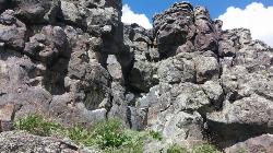
Basalt Bluff / Steve's Rock
Teton, Idaho
14.4 miles NDon't go anywhere marked No Trespassing and Beware of the Attack Bees at the top of the cliffs and the Stinging Nettle at the bottom. About a mile north of Loon Lake/Wentworth Springs Road...
Rock Climb
Market Lake Wildlife Management Area
Roberts, Idaho
26.1 miles WMallards, Canada geese, canvasbacks, cinnamon and green-winged teal, northern shovelers and ruddy ducks are common waterfowl species nesting and raising broods on the WMA. Several thousand...
Hike, Horseback 5.6-8.3 mi
Palisades Creek Trail / Lakes and Waterfall Canyon
Irwin, Idaho
27.7 miles SEPalisades Creek Trail is located about 50 miles southeast of Idaho Falls and about 60 miles west of Jackson Hole WY in Swan Valley Idaho. The four mile hike up to lower Palisades Lake or the 6.2 mile...
Backpack, Camp, Hike, Horseback, Mountain Bike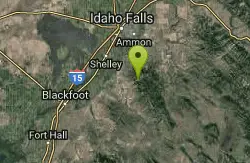
RPM Wall
Firth, Idaho
28.8 miles SWWolverine Canyon is full of limestone. The RPM wall being the currently developed wall and has some decent routes.
Rock Climb
Badger Creek
Tetonia, Idaho
29.4 miles NEBadger Creek is a stream located just 13.6 miles from Ashton, in Teton County, in the state of Idaho, United States, near France, ID. Whether you’re spinning, baitcasting or fly fishing your...
Camp, Cross-country Ski, Hike, Mountain Bike, Rock Climb
Bear Creek Campground at Palisades
Irwin, Idaho
30.8 miles SEPalisades Reservoir is ideal for water skiing in the summer and features many picnic spots and boat docks. The area forest service hosts nine campgrounds containing 181 family units. Boat launch...
Camp, Hike, Horseback, Mountain Bike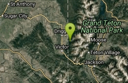
Darby Canyon Cliffs
Alta, Wyoming
31.6 miles EAn interesting cave by Darby Canyon is the major draw to this popular west slope hike, closely followed by intermittent waterfalls splashing down the canyon rim along with impressive displays of...
Rock Climb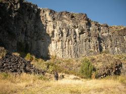
The Playground
Shelley, Idaho
32.6 miles SWThe Playground is a fun, moderate to hard place to sport rock climb. You can find approximately nine routes (popular ones include: Tied to the Whipping Post, Cure for the Hangover, Anchored to...
Rock Climb 13.2-13.5 mi
Bear Creek Hot Springs
Irwin, Idaho
32.8 miles SEBackpack, Camp, Hike, Horseback, Hot Springs, and Mountain Bike near Irwin, Idaho
Backpack, Camp, Hike, Horseback, Hot Springs, Mountain Bike 3.9 mi
Little Elk Creek Trail
Irwin, Idaho
32.9 miles SEBackpack, Hike, Horseback, and Mountain Bike near Irwin, Idaho
Backpack, Hike, Horseback, Mountain Bike 0.1-6.2 mi
Darby Wind Cave
Driggs, Idaho
34.3 miles EDarby Wind Cave is a beautiful hike full of waterfalls, wildflowers, streams, and mountainous views. The sites you see will depend on the time of year you visit but it will always be beautiful and...
Backpack, Cave, Hike, Rock Climb 13.8 mi
Big Elk Creek
Irwin, Idaho
34.7 miles SEBig Elk Creak Campground is a very versitile campground with plenty of activities to keep busy. Campgrounds are available, with three group sites that include picnic tables and campfire rings. There...
Backpack, Camp, Canoe, Hike, Horseback, Kayak 3.2-47.0 mi
Yellowstone Branch Line Trail
Ashton, Idaho
37.3 miles NEYellowstone branch line trail runs from Warm River to the Montana border totaling 39 miles. There are a few places to jump on and off the trail as well as a few smaller trails that branch off of this...
Backpack, Cross-country Ski, Hike, Horseback, Mountain Bike 15.0-18.4 mi
Alaska Basin
Driggs, Idaho
37.7 miles EThe Alaska Basin Trail is a stunning trail through the Jedediah Wilderness near Driggs, Idaho and goes East into Wyoming, just outside of Grand Teton National Park. The trail is wide...
Backpack, Hike, Horseback
Indian Creek Campground (Palisades)
Irwin, Idaho
39.5 miles SEPalisades Reservoir is a picturesque body of water in eastern Idaho on U.S. Highway 26 near the Idaho & Wyoming border and about 25 miles west of Jackson Hole Wyoming. The reservoir is nestled...
Camp, Hike, Horseback, SwimNearby Campsites

Kelly Island Campground
Ririe, Idaho
1.1 miles SWThis is a BLM campground with 14 campsites for RVs or tents and 1 group campsite. Daily Rates $5-20 Showers No Bathrooms Vault...
Camp
Table Rock Campground
Ririe, Idaho
3.2 miles ETable Rock / Poison Flat Campground is located at the Caribou-Targhee National Forest which occupies over 3 million acres and stretches across southeastern Idaho, from the Montana, Utah, and Wyoming...
Camp
Big Hole Dispersed Campsites
Ririe, Idaho
3.3 miles NEA dispersed campsite is simply an unestablished and unmaintained area where people camp. Often, this means that there is a campfire or other basic campsite feature to identify the site and that's...
Camp
Wolf Flats Recreation Area
Ririe, Idaho
3.5 miles SEWolf Flats is a completely free, dispersed, undeveloped camping area with 25 locations to camp. Some areas are large enough to accommodate groups of 50 people.
Camp 0.5-3.5 mi
Webster's Dam
Ririe, Idaho
4.9 miles NEAlso known as Manmade Falls or the Woodmansee Dam, Webster Dam is an abandoned dam located deep in Moody Creek canyon, the dam was abandoned when sediment built up behind the dam which then...
Camp, Hike, Mountain Bike
Twin Bridges Park
Rexburg, Idaho
6.1 miles NWTwin Bridges is a campground 12 miles South East of Rexburg on S. 600 E. It is maintained by Madison County Parks Department. It is a 27 acre park of pristine land rich with wildlife on the Snake...
Camp, Canoe
Moody Meadows
Driggs, Idaho
9.9 miles EGood place for kids, they can ride bikes in the meadow, play in the stream, and camping is off of the road. Hiking, motorbiking, and horseback riding trails are abundant in the area.
Camp
Jefferson County Lake (AKA Rigby Lake)
Rigby, Idaho
13.2 miles WRigby Lake has long been a favorite swimming hole for those in the area. The county has taken it well under its wing and made it a buzzing spot on any warm summer day. Along with the long standing...
Camp, Canoe, Dive, Kayak, Sled, Swim 0.1-0.5 mi
Eagle Park
Rexburg, Idaho
15.4 miles NWEagle Park is a little urban oasis. Once you drive in to this cottonwood forest along the river, you may forget that you're still inside Rexburg city limits. You can camp, picnic, throw rocks in...
Camp, Hike, Mountain Bike, Sled
Beaver Dick Park
Rexburg, Idaho
18.0 miles NWBeaver Dick is a park 4.5 miles west of Rexburg, Idaho on Hwy 33. It's a 9.5 acre park that passes next to the west bank of the Henry Fork of the Snake River; it's a popular...
Camp, Canoe, Disc Golf, Swim 0.8-1.3 mi
Warm Slough Campground
Rexburg, Idaho
19.3 miles NWThis is a pretty popular campsite that fills up pretty quick on busy weekends. Campsites are fairly spread out and there is no official donation box (as of July 2015). A couple of the campsites...
Airsoft, Camp, Canoe
Fall Creek Falls
Swan Valley, Idaho
19.5 miles SEFalls Campground is located next to the Snake River near beautiful Swan Valley, only 45 miles east of Idaho Falls, Idaho. Mixed growth cottonwood trees provide partial shade, and grassy meadows with...
Camp, Cave, Hike, Kayak, Swim 0.6-2.0 mi
North Menan Butte ('R' Mountain)
Menan, Idaho
19.6 miles NWThe North Menan Butte is more commonly known to the locals and college students as R Mountain. Many kids know it better as Ou'R' Mountain. The butte is a rare and unique geological area and provides...
Camp, Cave, Hike
Falls Campground
Victor, Idaho
20.4 miles SEFalls Campground is located next to the Snake River near beautiful Swan Valley, only 45 miles east of Idaho Falls, Idaho. Mixed growth cottonwood trees provide partial shade, and grassy meadows...
Camp
Pine Creek Campground
Victor, Idaho
22.8 miles EThe Pine Creek Campground has 10 single units and has restrooms.
Camp 5.6-8.3 mi
Palisades Creek Trail / Lakes and Waterfall Canyon
Irwin, Idaho
27.7 miles SEPalisades Creek Trail is located about 50 miles southeast of Idaho Falls and about 60 miles west of Jackson Hole WY in Swan Valley Idaho. The four mile hike up to lower Palisades Lake or the 6.2 mile...
Backpack, Camp, Hike, Horseback, Mountain Bike
Sealander Park
Idaho Falls, Idaho
29.3 miles SWThe story of Sealander park begins with Carl Sealander. Leaving Sweden in 1893 at the age of seventeen, Carl worked in mining communities across Colorado and Utah before meeting his wife, Lizzie...
Camp
Badger Creek
Tetonia, Idaho
29.4 miles NEBadger Creek is a stream located just 13.6 miles from Ashton, in Teton County, in the state of Idaho, United States, near France, ID. Whether you’re spinning, baitcasting or fly fishing your...
Camp, Cross-country Ski, Hike, Mountain Bike, Rock Climb
Mike Harris Campground
Victor, Idaho
29.8 miles EMike Harris Campground is located along scenic Teton Pass, just 5 miles from Victor, Idaho at an elevation of 6,200 feet. Visitors enjoy fishing, exploring local trails and sightseeing in this...
Camp
Bear Creek Campground at Palisades
Irwin, Idaho
30.8 miles SEPalisades Reservoir is ideal for water skiing in the summer and features many picnic spots and boat docks. The area forest service hosts nine campgrounds containing 181 family units. Boat launch...
Camp, Hike, Horseback, Mountain Bike


