


18 locations
Add Location


 Full Listing
Show more
Hike, Swim
Added on 21 Jul 2018
Full Listing
Show more
Hike, Swim
Added on 21 Jul 2018

Twin Falls
Austin, Texas
4.4 miles W of Austin, TexasHike and Swim near Austin, Texas
Full Listing
Show more
Hike, Swim
Added on 21 Jul 2018
Zilker Park
Austin, Texas
1.8 miles W of Austin, TexasHike and Swim near Austin, Texas
Full Listing
Show more
Hike, Swim
Added on 21 Jul 2018
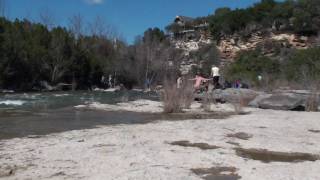
Sculpture Falls
Austin, Texas
4.8 miles W of Austin, TexasSculpture Falls is one of Austin's most beloved natural swimming holes, hidden along Barton Creek in the beautiful Barton Creek Greenbelt — a nearly eight-mile ribbon of wild limestone canyon that threads right through the heart of the city, a genuine slice of the Texas Hill Country just minutes from downtown. Here the creek spills over a broad shelf of sculpted ledges into a series of clear, cool green pools; over thousands of years the water has carved the soft Edwards limestone into the smooth, artful shapes and channels that give the falls their name.
Reaching it takes a little effort, which helps keep it a touch quieter than the busier greenbelt spots nearer downtown. Many hikers come in from the upstream end at the Trail's End access, home of the infamous “Hill of Life” — a steep, rocky descent that drops roughly 300 feet in half a mile and is the greenbelt's toughest pitch, beloved by trail runners and mountain bikers — then follow the creek a bit over a mile downstream, passing the popular Twin Falls along the way. You can also come from other trailheads like Gus Fruh or the Barton Springs end, though those make for a longer walk. At Sculpture Falls you'll find pools deep enough for swimming, flat ledges for lounging and sunbathing, and refreshing water around 70°F on a scorching Texas afternoon. It's dog-friendly, too, and the tall limestone cliffs that line the greenbelt draw rock climbers to routes nearby.
One crucial caveat: Barton Creek is spring- and rain-fed and runs seasonally, so it can drop low or dry up entirely during summer heat and Central Texas droughts. The falls are only worth the trek when the creek is actually flowing — the sweet spot is generally two to four days after a good rain, before the water turns murky or vanishes — so check recent conditions and rainfall before you go.
The greenbelt is ecologically special as well as scenic. Barton Creek recharges the Edwards Aquifer and feeds the famous Barton Springs downstream, home to the endangered Barton Springs salamander, so it's a place to tread lightly: use the trash cans, keep sunscreen, soap, and glass out of the pools, don't build rock dams, and stay on established paths to protect the fragile creek. On hot weekends it can get genuinely crowded, so an early start helps with both parking and solitude.
Practical notes: wear sturdy shoes with grip for the rocky, sometimes-slick trail and creek bed, and carry plenty of water for the hike, because there is none along the trail and the exposed stretches bake in summer. Watch depth before jumping from the ledges, keep a close eye on kids near the drop-offs, and be ready for a real workout on the climb back up the Hill of Life if you came in that way. Spring and early summer, in the days after rain, are absolutely prime — and if you time it right, Sculpture Falls is about as good as a wild city swimming hole gets anywhere in Texas.
Hill Of Life
Austin, Texas
4.9 miles W of Austin, TexasHike and Swim near Austin, Texas
Full Listing
Show more
Hike, Swim
Added on 21 Jul 2018
Campbell's Hole, Austin, TX, USA
Austin, Texas
2.6 miles W of Austin, TexasHike and Swim near Austin, Texas
Full Listing
Show more
Hike, Swim
Added on 21 Jul 2018
0.5-0.6 mi
 Full Listing
Show more
Hike, Mountain Bike
Added on 18 Jun 2018
Full Listing
Show more
Hike, Mountain Bike
Added on 18 Jun 2018
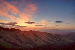
Grizzly Peak Trail
Berkeley, California
2.1 miles NE of Berkeley, CaliforniaGrizzly Peak Trail is located near La Loma Park in the Berkeley Hills section of the city of Berkeley, California and leads to an incredible lookout of the San Francisco Bay area. Driving up Grizzly Peak Road there are many spectacular places to pull over to take photos. This is a great hike to take out-of-town guests or tourists to go on, and it can be done on the way to or from Oakland/Berkeley.
Many runners have said that this trail is great for running and that the peak is a great place to stop and enjoy the view. If you choose to run to the peak and back, it would be about a 1-mile run, roundtrip. If you want to run the whole trail, it would be a little over 2 miles. This trail is dog-friendly, however, you should keep your dog on a leash. This hike is the best and most beautiful when done on a clear day, so be sure to check the weather the day before your hike.
The peak can be climbed almost year round because its elevation is relatively low. During periods of recent snowfall, it may be best to avoid the peak because of the ice and snow. Snow doesn't last too long on the peak, usually melting off most of the routes within a few days of snow. In the height of summer, temperatures may be too warm for an enjoyable climb.
The peak was named because of the Grizzly bears inhabiting the area until the late 1880s. The last grizzly in all of California was killed in the Sierra foothills east of Fresno in August 1922.
0.3 mi
 Full Listing
Show more
Hike
Added on 18 Jun 2018
Full Listing
Show more
Hike
Added on 18 Jun 2018
Burney Falls
Burney, California
9.2 miles N of Burney, CaliforniaBurney Falls has been considered one of the most spectacular waterfalls in the state. It stands at 129 feet tall and is coated by curtains of green fern. The best part about this waterfall, for many hikers and Californians is that it flows year-round. This is one of the very few waterfalls in California that has good water flow throughout the year. The waterfall is loud, but can also be pretty remarkable in how peaceful it can feel.
The main attraction, can be accessed directly from the parking area or through many different trails which lead to higher or lower views of the falls. Each angle is beautiful in their unique ways. The best time of the day to go is earlier in the morning and a little before sunset. If you go in the middle of the day, it could get crowded. Â
The water temperature never rises over 42 degrees Fahrenheit, but the fisherman never seem to mind because of the great fishing that happens. The fishing that takes place is catch-and-release fly fishing.Â
There is an $8 day-parking fee at this park. Do not park on the street near the entrance of the park, because your car could be subjected to citations or be towed.Â
0.4 mi
 Full Listing
Show more
Hike
Added on 18 Jun 2018
Full Listing
Show more
Hike
Added on 18 Jun 2018
Glen Alpine Falls
South Lake Tahoe, California
6.6 miles SW of South Lake Tahoe, CaliforniaAs you drive up to the falls, take a look around. The views are spectacular. The drive can feel long, but the waterfall is peaceful and worth the drive. This waterfall is considered one of the shorter waterfalls around but it is wider. It is a peaceful location because of the sounds of birds chirping and the water flowing.
The best time to come to the waterfall is the middle of spring (June) all the way until the end of summer (August). That is when the water flow is the strongest and the most beautiful.
Something to keep in mind, there is no real trail to the falls, just because you can park right near it. But there are many places to park alongside the road, and you can walk up that road to the falls. There is an overlook point that you can sit at and watch the water flow down. If you are more adventurous, you can climb down the rocks to the water below.
Be sure to check it out when you are in or near Lake Tahoe.
4.0 mi
 Full Listing
Show more
Hike
Added on 18 Jun 2018
Full Listing
Show more
Hike
Added on 18 Jun 2018
Palomarin Trail
Bolinas, California
3.7 miles NW of Bolinas, CaliforniaThis hike is about 5 miles north from Bolinas is the Palomarin Trailhead. As you hike the trail you overlook the ocean and beautiful beaches. The trail takes you up to different lakes and then ends at the beautiful Alamere Falls. Enjoy the stunning views of the pacific combined with varying terrain through forests, tall brush, and exposed dirt trails.
If you hike to falls during the summer, something great to do on your way back to the trailhead is to take a swim in Bass Lake. When you reach the path near the coast, it gets more narrow and steep. You'll often notice a little traffic jam as people figure out how to navigate their way down.
There are two steep parts when you're heading to the coast. The first steep path leads you just above the main part of the falls where you will see smaller waterfalls and the second leads you to the beach. If there are other people on the path with you, just leave room between you and them when you're headed down to the beach, just to ensure safety.
This is not a dog friendly path.
KEEP IN MIND: When you reach beach to the falls, remember that the park staff would prefer that visitors do not go to Alamere Falls itslef; it is advised that you view the falls from the beach. However, there is a "path" to the falls that is well known and can be navigated safely to get to the falls. Just remember to proceed with caution.
3.8 mi
 Full Listing
Show more
Hike
Added on 18 Jun 2018
Full Listing
Show more
Hike
Added on 18 Jun 2018
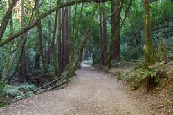
East Ridge Trail
Oakland, California
6.9 miles E of Oakland, CaliforniaThis trail is deeply tucked away up into the hills of Oakland. East Ridge is the perfect trail to deeply appreciate the beauty of the Redwoods and has many entry points. This trail weaves through grassy meadows and over ridges and steep slopes. This trail has shady parts and will lead you to the falls.
This trail on this hike is wide, even and gentle. This hike is accessible to all hikers that want to enjoy it. This trail winds steeply down to the valley floor and after rain, can be very slippery. Hikers that hike at a normal, relaxed pace, can complete this loop in about 2-3 hours. If speed is your thing, trails are equally ideal for trail running.
This hike is accessible all year round. This trail is exposed and can be pretty hot and dusty in the summer. During the rainy seasons, trails can be slippery and muddy after rain. During the winter season, keep your eye out for the massive clusters of ladybugs that migrate to the park’s trees each winter along the park’s coast redwoods.
Dogs must be leashed if you take them on this hike. The main entrance, Redwood Gate, charges a $5 parking fee during peak season. The park is opens at 5am and closes at 10pm. So if you like hiking or running at the crack-of-dawn or would prefer going after work, you can enjoy the trail and facilities.
5.6 mi
 Full Listing
Show more
Hike
Added on 18 Jun 2018
Full Listing
Show more
Hike
Added on 18 Jun 2018
Quarry Trail
Cool, California
2.0 miles N of Cool, CaliforniaThis is a hike along the river and an old, historic railway. The trail leads you to a a beautiful amphitheater carved from limestone.You are surrounded by beautiful nature and peaceful noises. The trail is wide and you can take your time to take in all the beauty. The only part that is a little more difficult is the last stretch up to the quarry.
The railway that you will see used to carry out limestone and was taken 7 miles to Auburn for cement productions. Each train was filled about four times a day. In 1942, the metal from the old railway was used as scrap metal during WWII.
There are some places on the trail that aren't clearly marked, especially when you get to the quarry. Stay wary of where you are and keep an eye out for signs that will guide you to where you need to go. The trail is great all year around, but between April and June, the wildflowers are the most beautiful.
KEEP IN MIND: California does charge $10 as a day-use fee for each car going into the parking area, although prices are subject to change. Dogs are allowed if they are leashed. There are no bikes allowed on this hike.
0.4-0.9 mi
 Full Listing
Show more
Hike
Added on 1 Jun 2018
Full Listing
Show more
Hike
Added on 1 Jun 2018
Wild Basin Wilderness Preserve
Austin, Texas
5.7 miles NW of Austin, TexasThis trail and preserve is a great place to hike and explore nature. You can get a guided tour, which allows for a more educational experience, or you can take your time to just enjoy the scenery and peacefulness. You can choose the difficulty of your hike. You can choose an easier loop or hike all the way around the preserve.
There is a donation box at the trailhead for $3.00 per person. That is also where you will find the different hikes and their difficulty. The "Easy Access Loop" is stroller-friendly for moms who have babies and want to take a little hike. There is a lot of things to see and do in the preserve. You could make this a day activity, or shorten it depending on your schedule.
Trails are available daily from sunrise to sunset. The Wild Basin Creative Research Center is open Monday through Friday from 9:00 a.m. until 4:00 p.m. Parking and restrooms are available. Wild Basin offers educational events, guided hikes for the public and school field trips, volunteer workdays, and classroom space.
Pets, bikes and food are prohibited to keep the preserve clean and the species safe. Smoking is also prohibited. If you have any questions about anything, contact the preserve's Visitor Center.
1.2 mi
 Full Listing
Show more
Hike
Added on 1 Jun 2018
Full Listing
Show more
Hike
Added on 1 Jun 2018
Barton Creek Greenbelt
Austin, Texas
4.4 miles W of Austin, TexasThis hike can be up to 7.9 miles long and starts up near Zilker Park. You can choose the length of your hike, walk, or run. The easiest access to the Greenbelt, though, is through the Loop 360 Entrance. This location is filled with biking, hiking and running trails. There are great locations to have picnics.
On the trail there are a couple of great swimming locations. When the water levels are right these are the access points to go to to find the best swimming locations:
- Spyglass Access (1601 Spyglass Dr.): There is usually easy-access street parking at this location. Once you head down the hill at the trail access, take a left and you’ll find your way to the Flats & the Campbell’s Hole swimming spot.
- Gus Fruh Access (2642 Barton Hills Dr.): You could get to Gus Fruh from the Spyglass entrance and just simply keep going, but you can take a more direct route and park in this residential neighborhood. The water in this location is beautiful and the swimmning is perfect.
- Trail End/Sculpture Falls Access (1710 Camp Craft Road): Here you will find the trails end, the famous Hill of Life and the Sculpture Falls swimming area. Be warned, however, that you’ll need to be ready for a half-mile uphill hike to get to the falls. The falls are small and beautiful and is a great location for family-friendly fun.
This trail is open year-round and have great activities for families. The best times to go are earlier in the day before it gets too hot and right before the sun sets.
0.3 mi
 Full Listing
Show more
Hike
Added on 1 Jun 2018
Full Listing
Show more
Hike
Added on 1 Jun 2018
Mayfield Nature Preserve
Austin, Texas
3.6 miles NW of Austin, TexasMayfield has so many great trails. There are a couple of loops you could travel that leads you to other trails, and will take you on many adventures around the preserve.
Please remember that Mayfield is a nature preserve, so when visiting, it is especially important to leave the wildlife alone, including the peacocks around the garden.This is to ensure their and your safety. When roaming the preserve refrain from boisterous activities and let the serenity of the area surround you.
Mayfield Park includes a historic cottage, 2 acres of colorful cottage gardens with beautiful, large palm trees, bright peacocks and beautiful water lilies. Mayfield Preserve is a 21 to 22 acre natural area that surrounds the park, containing walking trails and wildlife habitats.
Something to keep in mind that makes Mayfield interesting, is that it is a feature that makes GPS readings harder to come by. The heavy foliage cover over much of the park provided uneven GPS reception for much of the hike, but you can find the hike marked on the trails.
IMPORTANT INFORMATION: Open daily during weekdays between 8:30 am until 4:30 pm, but closed during the weekend. There are no pets allowed because of the wildlife. If you are looking to reserve a spot, or are a photographer, you must read through these guidelines to know who to contact.
0.1-0.9 mi
 Full Listing
Show more
Hike
Added on 31 May 2018
Full Listing
Show more
Hike
Added on 31 May 2018
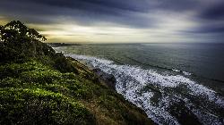
Natural Bridges State Park / Monarch Butterfly Trail
Santa Cruz, California
2.0 miles SW of Santa Cruz, CaliforniaThis trail is perfectly tucked away from the business of Santa Cruz. Monarch butterflies, during the Winter, fly here to stay warm. As you walk through the Monarch Grove, you will see trees covered with butterflies. Their wings fluttering look like tree leaves blowing in the wind, until you take a closer look. It is a peaceful place to be as you learn about Monarch butterflies and watch them fly around.
Monarch butterfly migration begins at different times but they start arriving in the grove around mid-October. This is the perfect time of year to take a nice stroll on the boardwalk and watch the butterflies. The park is filled with eucalyptus trees which give the butterflies the perfect protection for them in the winter months. Since this is a preserve, it is asked not to grab or hold butterflies and to stay quiet to help continue making them feel safe. The end of the Monarch season is around mid-February. It is the perfect, family friendly location.
There is one main trail, but you can customize the length of your walk/hike depending on what you would like to do.
The trail leads to a beautiful sandy beach. You will see a huge, beautiful rock arch to your left of the beach. The water is refreshingly cool. Watching the sunset over the water, pulls out the orange colors of the arch rock making the scene bright and peaceful.
This is the perfect location to see shore birds, migrating whales, and playing otters offshore. As you continue to walk around the beach, you will come across tide pools where you can get a glimpse of sea life. The low tide allows visitors to see star fish and other sea animals. It is a great location for families to explore and enjoy their time together.
Important Information: There is a $10 vehicle day-use fee. The water is shallow enough for children to play safely, but it is necessary for parents to supervise their children because there aren't lifeguards on duty. Bikes are permitted on the paved roads around the park and beach. Dogs are also permitted on paved roads and in the park but not on the beach.
1.5 mi
 Full Listing
Show more
Hike
Added on 31 May 2018
Full Listing
Show more
Hike
Added on 31 May 2018
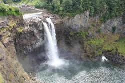
Twin Falls Trail
North Bend, Washington
5.5 miles SE of North Bend, WashingtonDuring this three mile hike, you'll be trekking near the river. You will be surrounded by the peaceful sound of rushing water. About a mile and a half into the hike, you will arrive at the viewpoint bridge, which allows people the opportunity to view the beautiful waterfall. Rain or shine, this is a beautiful hike to embark on.
This amazing route has easy access to the river. It also provides plenty open places and overlooks which allow hikers of all ages and skills to go at their own comfortable pace. Due to the closeness to the many larger metropolitan areas near the trail, makes this a heavily used trail during the weekends. Using this trail on weekdays is highly recommended.
History of the location: This trail was forced to be closed at the beginning of 2014 dues to heavy rainfall and erosion that wiped out a key section of the trail. But, fortunately, through the work of EarthCorps, a local nonprofit, the trail was rerouted and rebuilt so the community could once enjoy the iconic Twin Falls and then reopened in May of 2016.
To many people, this is a must-see and must-do hike because it is peaceful, beautiful and enlightening.
5.4 mi
Middle Fork Snoqualmie Trail
North Bend, Washington
12.2 miles E of North Bend, WashingtonCLOSED. Closed due to landslide activity.
Full Listing
Show more
Hike, Mountain Bike
Added on 31 May 2018
1.3 mi
 Full Listing
Show more
Hike
Added on 31 May 2018
Full Listing
Show more
Hike
Added on 31 May 2018
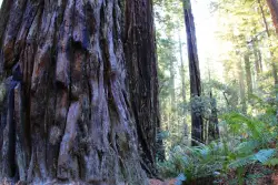
Lady Bird Johnson Grove Trail
Orick, California
2.5 miles NE of Orick, CaliforniaThis is a short hike that surrounds you with greenery and beautiful, tall trees. As you hike through the grove, you may hear birds chirping, but you will mostly just hear your feet walking on the dirt trail. It is a quiet, peaceful place to go to escape the day-to-day noise.
For a major redwood attraction, this trail is, unusually, at 1200 feet above sea level. This ridgeside grove is spectacular because it is much more than shrubs and trees.The trees are very tall and the greenery that surrounds you is brilliant. This grove is free of noise from the city traffic because of it's elevation. It is often in the clouds and gets a lot more fog than lowland groves.
History of Location: President Richard Nixon, in August 1969, dedicated the grove to Lady Bird Johnson who was an environmental activist, women's right activist, as well as former first lady. Richard Nixon named the grave after Mrs. Johnson because of the beautiful works she accomplished in her life and how the grove echoed that sentiment.
This is a free attraction, about a mile and a half, round-trip, surrounded by lots of parking, and a visual trail guide is available for purchase, for a dollar.
×


