


Refine Search
- hike 14
- camp 8
- rock climb 5
- backpack 5
- mountain bike 4
- sled 3
- cross-country ski 3
- cave 3
- horseback 3
- swim 2
- dive 1
- disc golf 1
- kayak 1
22 locations
Add Location
 Full Listing
Show more
Cross-country Ski, Hike, Kayak
Last visited on 22 Sep 2019
Full Listing
Show more
Cross-country Ski, Hike, Kayak
Last visited on 22 Sep 2019
 Full Listing
Show more
Cave
Last visited on 8 Aug 2017
Full Listing
Show more
Cave
Last visited on 8 Aug 2017
 Full Listing
Show more
Camp, Hike
Last visited on 24 Apr 2017
Full Listing
Show more
Camp, Hike
Last visited on 24 Apr 2017
 Full Listing
Show more
Sled
Last visited on 18 Feb 2017
Full Listing
Show more
Sled
Last visited on 18 Feb 2017
 Full Listing
Show more
Rock Climb
Last visited on 30 Jul 2016
Full Listing
Show more
Rock Climb
Last visited on 30 Jul 2016
 Full Listing
Show more
Camp, Hike
Last visited on 23 Jul 2016
Full Listing
Show more
Camp, Hike
Last visited on 23 Jul 2016
 Full Listing
Show more
Dive, Swim
Last visited on 15 Jul 2016
Full Listing
Show more
Dive, Swim
Last visited on 15 Jul 2016
 Full Listing
Show more
Sled, Swim
Last visited on 24 Apr 2016
Full Listing
Show more
Sled, Swim
Last visited on 24 Apr 2016
 Full Listing
Show more
Camp, Hike, Horseback
Last visited on 26 Jun 2015
Full Listing
Show more
Camp, Hike, Horseback
Last visited on 26 Jun 2015
Mesa Falls
Ashton, Idaho
10.0 miles NE of Ashton, IdahoUpper Mesa Falls, aka Big Falls, is an absolutely awesome waterfall on the Henrys Fork of the Snake River. The falls drop 114 ft. and measure 300 ft. across. To get to the falls from the parking lot is 0.2 miles of paved walkway and several sturdy stairs with plenty of gaurdrails and handrails. There are several platforms along the route for viewing and taking photos. Catch it in the morning to see the rainbows in the lingering mist that often rises well above the platforms. There's a wheelchair accessible path that can get a pretty good view of the falls but does not go right down to it.
Lower Mesa Falls is about a mile down river from the Upper Falls. There's two great viewing options. One is from a cliff hovering 200 feet above the falls and the other is from the the Observation Site sitting 0.25 miles away and almost 500 feet above the falls. To get to the cliff above the falls, there's a trailhead on the South East end of the main parking lot. The trail is 1 mile each way (2 mile out and back) with about a 100 ft. difference in elevation (about the same as the stairs the the Upper Falls platforms). The trail goes through the woods well away from the river itself but there are no guardrails at the end when you're peering over the edge of the cliffs to see the waterfall. To see the falls from the observation site is free and the walk from your car to the lookout is only about 500 ft.
This is an Idaho State Park and there are day use fees. Passes have reciprocity with Harriman State Park which is only about 20 minutes away. Get there before 5pm to check out the old inn which has been transformed into a fun and informative visitor's center.
3.9-14.4 mi
 Full Listing
Show more
Backpack, Hike, Rock Climb
Last visited on 17 Aug 2019
Full Listing
Show more
Backpack, Hike, Rock Climb
Last visited on 17 Aug 2019
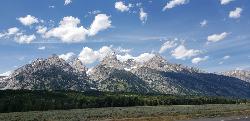
Grand Teton
Jackson Hole, Wyoming
17.6 miles N of Jackson Hole, WyomingAt 13,770 feet above sea level, the Grand Teton towers majestic over Southeastern Idaho and Western Wyoming, making it a life goal of many amateur climbers and outdoor enthusiasts.
The more popular routes all begin at the Lupine Meadows Trailhead and continue up through Garnet Canyon and The Meadows before splitting North. Most routes require rock climbing equipment and are only for skilled climbers. A guide is highly encouraged on any route. With 3k feet of exposure, falling from multiple segments of the trail would mean certain death.
Trailhead altitude: 6,732 ft
Summit altitude: 13,770 ft
Rexburg Area Ice Caves
Rexburg, Idaho
29.1 miles N of Rexburg, IdahoNot to be mistaken with the Civil Defense Caves (which are near by), the Ice Caves are about an hour North outside of Rexburg. The Ice Caves were originally formed as lava tubes. The shape of the caves traps cold winter air in the cave and forms large areas of ice on the floor and beautiful ice crystals on the walls and ceiling. The ice remains frozen year round and makes for an awesome time. The ice caves are a few hundred yards deep and require good footwear, warm clothes and a flashlight to navigate. There is often a good amount of water near the entrance. There's a bridge of rocks across the area but you may get a little wet getting in the cave. There are areas where you'll need a rope to be able to ascend portions of ice. Please do not light fires or introduce any other heat source into the caves.
3.2-47.0 mi
 Full Listing
Show more
Backpack, Cross-country Ski, Hike, Horseback, Mountain Bike
Last visited on 20 Jul 2017
Full Listing
Show more
Backpack, Cross-country Ski, Hike, Horseback, Mountain Bike
Last visited on 20 Jul 2017
Yellowstone Branch Line Trail
Ashton, Idaho
7.6 miles NE of Ashton, IdahoYellowstone branch line trail runs from Warm River to the Montana border totaling 39 miles. There are a few places to jump on and off the trail as well as a few smaller trails that branch off of this larger trail. A lot of the traffic covers small portions of this trail so not many people tackle the trail in its entirety. The trail offers a variety of different activities. It is open for backpacking, hiking, mountain biking, horseback riding, and all terrain vehicles under a certain size. Depending on what you want to spend your day doing it’s a good idea to plan accordingly.
Also known as The Great Western Trail of Idaho, The Warm River Rail Trail, Route of the Yellowstone Special, or the northern portion of the Yellowstone Grand Teton Rail Trail.
2.8-4.1 mi
 Full Listing
Show more
Backpack, Camp, Hike, Horseback, Mountain Bike
Last visited on 3 Jun 2017
Full Listing
Show more
Backpack, Camp, Hike, Horseback, Mountain Bike
Last visited on 3 Jun 2017
Palisades Creek Trail / Lakes and Waterfall Canyon
Irwin, Idaho
4.4 miles E of Irwin, IdahoThe Palisades Creek Trail is one of the classic hikes and backpacking trips of the Swan Valley region, climbing a gorgeous glacier-carved canyon to a pair of mountain lakes on the edge of the Palisades Wilderness Study Area, about 50 miles southeast of Idaho Falls (and an hour west of Jackson, Wyoming). Following clear, tumbling Palisades Creek nearly the whole way, it's a well-maintained, moderately graded trail that rewards hikers with waterfalls, wildflowers, and some of the finest mountain scenery in eastern Idaho.
The trail begins at the well-signed Palisades Creek trailhead at the end of the county road above the little community of Irwin, where there's a parking area and a Forest Service trailhead. From there the path threads a dramatic canyon of towering rock walls, crossing the creek on sturdy bridges and passing several waterfalls that spill from the heights — scenery that makes even the day hike to the lower lake feel like a true mountain adventure. Because it's so scenic and so accessible, it's deservedly popular; there's no permit or fee to hike, but weekends draw a crowd, and backpackers should plan for company at the more sought-after campsites.
It's about 4.3 miles to Lower Palisades Lake, gaining a gentle thousand feet or so — an ideal day hike or first-time backpacking trip. Strong hikers and overnighters can push on another 2.5 miles to Upper Palisades Lake (around 14 miles round trip), leaving the main trail to turn up Waterfall Canyon, where the namesake cascades tumble down the walls. Both lakes were formed ages ago when massive landslides came down the canyon and dammed the creek. The upper lake generally offers better backcountry camping, since the closer sites at the lower lake fill up first.
The fishing is superb. Palisades Creek is a major spawning tributary for the famous South Fork of the Snake, and it and the lakes teem with native Yellowstone cutthroat trout — a wonderful place to cast a line or simply relax by the water. Wildlife is everywhere: hikers regularly see moose (often standing belly-deep in the lakes), along with elk, deer, waterfowl, and mountain goats on the high walls.
This is genuine bear country — both black bears and grizzlies range here — so carry bear spray, know how to use it, make noise on blind corners, and store all food properly, especially if you camp. Because the trail lies within a Wilderness Study Area, it's open to foot and horse travel only (no bikes or motors), which helps keep it wild and quiet.
Timing matters: early in the season the trail can run with snowmelt and the lakes can be muddy and high, so late summer into fall is often the sweetest window — drier trail, settled lakes, and golden hillsides. Bring bug protection for early summer, plenty of water, sturdy footwear for the creek crossings, and layers for fast-changing mountain weather, and you'll quickly understand why Palisades Creek is such a regional favorite.
6.2 mi
 Full Listing
Show more
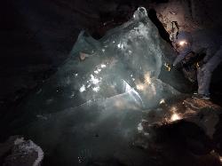
Backpack, Cave, Hike, Rock Climb
Last visited on 26 May 2017
Full Listing
Show more
Backpack, Cave, Hike, Rock Climb
Last visited on 26 May 2017
Darby Wind Cave
Driggs, Idaho
7.6 miles E of Driggs, IdahoDarby Wind Cave is a beautiful hike full of waterfalls, wildflowers, streams, and mountainous views. The sites you see will depend on the time of year you visit but it will always be beautiful and just a little bit of a challenge.
The trail starts out relatively flat, following along close to where the old road used to run. There are a few creek crossings which will vary in difficulty depending on how much snow there was over the winter and how long it's been since things began to thaw. Late summer will usually find you crossing dry or nearly dry creek beds. If you hike when runoff is high, there are log bridges. You don't have to be highwire ready but one of the bridges will take a little bit of balance. The trail turns up South up into the canyon. About as soon as it starts to go up, you'll turn and begin a series of switchbacks (10 turns). These will take you up the East wall of the canyon.
The switchbacks are not incredibly steep but you'll gain elevation pretty quickly. After the switchback, the trail follows along a rim above the canyon where you can look across the canyon and see two beautiful waterfalls and mouth of the cave seemingly high overhead. At the South end of the canyon, you'll come across a rock overhang. It's fun at any time during the summer but earlier when the water is higher, you'll find a little waterfall and stream that the kids will love to play in and you'll be hard pressed not to soak your head and feet and cool off a bit yourself.
From the the overhang, the hike continues West along the South end of the canyon through some more forest and a beautiful meadow. Take a minute to look up from the trail to enjoy the view of Fossil Peak to the South. Just after the meadow, you'll begin another series of switchbacks up to the falls and cave. The first set (2 turns) will take you up to a dispersed campsite and monument. The next leg will take you to the creek where you can look up and get photos of the falls and cave. The next set puts you out just underneath a very large and beautiful waterfall that drops out over a ledge. The ledge itself is a popular repel accessible from above. You can walk all the way around these falls and even catch some spray on the downwind side. The next set of switchbacks are stairs cut out of the rock. Halfway will take you to an even better view of Fossil Peak and the remainder will take you to the mouth of the cave itself. To enter the cave, you'll have to cross one more creek which can be pretty scary and dangerous when the water is high. Entering the cave during high water can be just as scary.
Once you're in, the Wind Cave snakes through the Darby Formation, a thick layer of 350 million year-old dolomite. A flashlight for the cave is a definite must. Near the mouth, there's a series of ledges popular for bouldering. Just up about 100 yards, you'll come to a small hole you'll have to crouch to get through. You'll quickly realize why they're called the wind caves as you're blasted with wind from the caves coming out that hole. After about 200 yards, you'll want your climbing gear. The caves stretch for miles and if you go far enough, you'll enter the part known as the ice caves. Travel far enough, you'll come out the other side. Be careful though. The cave becomes pretty cavelike and it's really easy to get lost and, even in the busy season, it may be days until that nightmare ends with a rescue team.
The hike is about 3.1 miles from the South Fork Darby Canyon trailhead to the caves and is a 1,800 feet elevation gain. You'll find a lot of resources that claim the hike is a shorter distance. These sources either begin from the end of the old road or don't take into account one or both series of switchbacks. The cave itself sits at 8,940 feet above sea level.
0.3-0.6 mi
 Full Listing
Show more
Camp, Cross-country Ski, Hike, Sled
Last visited on 24 Apr 2017
Full Listing
Show more
Camp, Cross-country Ski, Hike, Sled
Last visited on 24 Apr 2017
Bear Gulch
Ashton, Idaho
9.7 miles NE of Ashton, IdahoBear Gulch is an abandoned ski hill out of operation since 1969.
While the vegetation is beginning to take over, there's still some great sledding to be had. It's just far enough into the hills that there's plenty of snow all through the winter and often from Fall to Spring. The most popular sledding run is on one of the overgrown ski runs. Starting above the parking lot it goes down through a "no motorized vehicles" gate and on down to the creek and old ski lift. Most people stick to the upper portion, especially with smaller children. However, there are a range of heights to start from so there really is something for all ages. The lower portion is faster and windy with usually a decent enough trail cut out that it guides you through every twist and turn all the way to the bottom. Being able to turn isn't essential but you may feel like slowing down or even stopping. Just be careful not to stop in front of somebody else. The hike up is pretty long and a little steep. Be sure to stay out of the way of other sledders coming down.
Y-Mountain Summit Trail
Provo, Utah
2.8 miles E of Provo, UtahY Mountain is located directly east of Brigham Young University (BYU) in Provo, Utah, United States. The Slide Canyon/Y Mountain Trail leads to a large block Y located 1.2 miles (1.9 km) from a parking area at the mountain's base. This hillside letter was built over a hundred years ago as the insignia for BYU. For years the trail to the Y has been one of the most hiked trails in Utah Valley and provides a beautiful view of Provo and Orem, the rest of the many cities in Utah Valley and Utah Lake. The trail is also regularly used by hikers, bikers, paragliders and hunters to access the backcountry in the Slide Canyon area.
The large white Y on the side of the mountain has become the nationally recognized insignia for BYU and the reason why BYU is often called "the Y". It is made of concrete and is 380 feet high and 130 feet wide (116 by 40 m). The Y is even larger than the "Hollywood Sign" in Los Angeles.
There are 14 strands of lights placed around the perimeter of the Y, which are lit five times a year by the Intercollegiate Knights. It is lit for Freshman Orientation, Homecoming, Y Days, and graduation in April and August.
Rock Canyon Park
Provo, Utah
2.6 miles NE of Provo, UtahThis is the biggest park in Provo, Utah, with lots to do. The hills are great for sledding.
0.8 mi
 Full Listing
Show more
Hike
Last visited on 15 Sep 2016
Full Listing
Show more
Hike
Last visited on 15 Sep 2016
Conant Creek Pegram Truss Railroad Bridge
Ashton, Idaho
5.0 miles SE of Ashton, IdahoAs part of the Rails to Trails project, this old railroad bridge has been transformed into a very safe little viewing experience for the whole family. You can drive right up to the bridge where there is a great little spot to park. Conant Creek meeanders hundreds of feet below the bridge. It's about 300 yards across and whether you're taking in the vibrant colors of spring, the beautiful fall colors, or the Tetons looming in the background, the view is spectacular.
The bridge is part of the 30 mile Ashton-Tetonia Trail. There is a smaller bridge less than 2.5 miles north on the trail.
3.8-6.4 mi
 Full Listing
Show more
Camp, Hike
Last visited on 4 Aug 2016
Full Listing
Show more
Camp, Hike
Last visited on 4 Aug 2016
Table Rock / Table Mountain
Driggs, Idaho
10.0 miles E of Driggs, IdahoAt roughly 11,100 feet, the flat-topped summit of Table Mountain serves up what many consider the single finest view of the Grand Teton anywhere — and one of the great day hikes on the quiet, western (Idaho) side of the range. From the broad mesa top you stand just far enough back to take in all three Teton peaks at once, yet close enough to pick out the detail on the Grand's sheer east face across the deep gulf of the canyon. It's a jaw-dropping payoff, and a hard-earned one.
The mountain holds a remarkable place in history. In 1872, pioneering survey photographer William Henry Jackson hauled his heavy glass-plate camera gear by mule to the top of Table Mountain and made the first photographs ever taken of the Grand Teton — images that helped introduce the range to the wider world and build support for protecting it. Jackson chose this peak precisely because its gentle western slopes could be reached without technical climbing, and that's still what makes the summit attainable for strong day hikers today.
The trailhead sits at the end of Teton Canyon Road outside Driggs and Alta, and nearly the entire route lies within the Jedediah Smith Wilderness of the Caribou-Targhee National Forest. There are two main ways up, and both climb over 4,000 feet. The Face Trail is the steeper, shorter option (about 3.5 miles one way), skipping the switchbacks to head more or less straight up. The Huckleberry (North Fork) Trail is longer but far more gradual (about 6.5 miles one way), following and crossing the North Fork of Teton Creek — handy spots to filter water — through meadows and, in mid-to-late summer, ripe huckleberries for those who beat the crowds to the bushes. Many hikers link the two into a big loop of roughly 11–13 miles, and tough-but-knee-conscious hikers generally prefer to climb up the steep Face and come down the gentler Huckleberry, sparing their knees the pounding of a steep descent. The lower trail is a delight in its own right, tracing rushing Teton Creek past a string of waterfalls.
The wildflowers here are spectacular. As the snow recedes, Table Mountain's meadows erupt in color — sweeping displays of lupine, arrowleaf balsamroot, and Indian paintbrush, with columbine in the shadier pockets and delicate alpine blooms up high. In the Tetons the canyon meadows tend to peak from early-to-mid July, while the highest ground saves its show for late July into August; even when snow still blocks the upper trail, the lower meadows near the trailhead put on an easy, photogenic display. It's one of the finest wildflower hikes in the region.
This is high, exposed country, so plan accordingly. At over 11,000 feet the air is thin and the weather changes fast: afternoon thunderstorms build quickly over the peaks in summer, so start early and aim to be off the open summit by early afternoon. Table Mountain is enjoyed year-round — it's a popular snowshoe and backcountry-ski destination in the snowy months. If you're after dry summer hiking, though, know that you're likely to encounter snow on the upper mountain before mid-July: early-season snowfields often begin around 9,500 feet with larger patches up high, and the Huckleberry side can hold avalanche debris and downed trees until it melts out. It's frequently still passable with the right footwear — just come expecting it. Conditions are typically most reliably snow-free from about mid-July through September. It's also easy to lose the trail, especially on the descent, so pay attention to your route and carry a map or GPS. Keep an eye out for wildlife, too — moose are a common sight in the canyon, and the area is home to the occasional mountain lion.
Bring layers, sun protection, plenty of water (and a filter), and sturdy footwear for the long, steep grade. You can check current conditions on the webcams at tetoncam.com before you drive up. Backpackers sometimes camp in the meadows below the summit to catch the Grand at sunrise — an unforgettable sight — while following Leave No Trace and wilderness regulations. However you do it, Table Mountain earns its reputation: a leg-burning climb to a mesa in the sky, carpeted in wildflowers, with the Grand Teton filling the horizon just as it did for Jackson a century and a half ago.
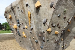
Phil Baux Park
Jackson, Wyoming
0.5 miles S of Jackson, WyomingPhil Baux park has your typical park equipment such as a playground, swing set, small picnic shelter, 8 picnic tables, horseshoe pits and plenty of green grass for other recreational activities.
What really makes this park unique is the Teton Boulder Project which consists of 3 large rock climbing structures. The structures are about 12 feet high and consist of natural style ledges and cracks as well as the screw on holds. There are overhangs and ascents. There are several marked routes. Skill levels range from the most beginner to the most advanced rock climbers.
Alongside the rock climbing walls is a memorial dedicated to those loved ones that have been lost to the mountains.
13.8 mi
 Full Listing
Show more
Backpack, Hike, Rock Climb
Last visited on 29 Jul 2016
Full Listing
Show more
Backpack, Hike, Rock Climb
Last visited on 29 Jul 2016
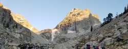
Middle Teton
Jackson Hole, Wyoming
17.6 miles N of Jackson Hole, WyomingAt 12,804 ft above sea level, the Middle Teton is a challenging and beautiful hike from the trailhead all the way to the peak. The first part of the trail is dirt trails through the trees. That becomes switchbacks after awhile. After about 4 miles, that emerges into a rocky trail where you begin walking below the towering peaks of the Middle and South Tetons. The trail remains rocky/gravelly until you get up through Garnett Canyon to The Meadows. This is a common place to pitch a tent. Many people use this as a base camp to hike the Middle, South, and Grand Teton.Â
Southwest Couloir
From The Meadows, the easy hike is over. It becomes bouldering up the hill among the glaciers. It's steep and deceiving. The next major checkpoint is the saddle between the Middle and South but there are about 3 false saddles before that. The real one is obvious. From the cliff that is the saddle, you can see Ice Flow Lake, the Alaska Basin trail, Table Mountain, Devil's Stairs, Battleship Mountain, The Wall, and everything in between. For many, this view is enough.
From the saddle, the trail continues up along the ridge and glaciers until you reach the Southwest Couloir. At that point, the trail becomes more of a scramble until you reach the top. From the top, you can clearly see the Grand Teton, as well as the South Teton, and Teewinot.
Cave Falls of Yellowstone
Ashton, Idaho
22.9 miles E of Ashton, IdahoCave Falls is one of Yellowstone National Park's most distinctive waterfalls — not for its height, but for its sheer breadth. Spanning some 250 feet across (nearly the length of a football field) while dropping only about 20 feet, this wide curtain of whitewater on the Fall River is the widest waterfall in Yellowstone. Tucked into the park's remote southwest Bechler region near the Idaho-Wyoming border, it's a beautiful and refreshingly uncrowded corner of the park.
Best of all, Cave Falls is wonderfully easy to reach — the falls sit right at the end of the road, just steps from the parking area, making this a rare Yellowstone gem accessible to nearly everyone, families included. From the same spot, a short, scenic walk along the Fall and Bechler rivers leads to lovely Bechler Falls, an easy add-on for a little more adventure.
The area is the gateway to Yellowstone's waterfall-rich Cascade Corner. Right at the falls, the Cave Falls Campground (in the Caribou-Targhee National Forest) offers riverside sites with fire rings and picnic tables plus excellent fishing on the Fall River, while the Bechler Ranger Station — the only entrance to this corner of Yellowstone — sits a couple of miles away.
To get there, drive east from Ashton, Idaho on ID-47 and then Cave Falls Road for roughly 24 miles (the last dozen on gravel). Summer through early fall is the season, once the gravel road is clear of snow. This is bear country, so carry bear spray and store food properly, and as always, pack out everything you bring in. Easy, scenic, and off the beaten path, Cave Falls is a perfect introduction to Yellowstone's wild Bechler country.
Twin Bridges
St. Anthony, Idaho
6.6 miles NE of St. Anthony, IdahoTwin Bridges is a beloved bridge-jumping and swimming spot on the river near St. Anthony, Idaho — a summer institution for families, teens, and college students across the upper Snake River Valley. The name comes from the setup: an old abandoned bridge stands right beside the one still in use, and the deep, slow water beneath the old span makes for about the best bridge jumping around, with no traffic to dodge and easy parking nearby.
The jumping is the main event, and it's well suited to a range of nerve. There are two distinct levels to leap from — a lower point around 11 feet and a higher one around 17 feet — so you can start small and work your way up, and the water below is plenty deep for cannonballs, flips, and gainers. Locals consider it about as good and as “reasonably safe” as bridge jumping gets, with one firm caveat: keep clear of the rocks along the sides, which can be exposed depending on the water level.
There's more to it than jumping. A little rope swing often hangs under the bridge — a favorite of the little kids — and a path up the river makes a good put-in for a short, mellow float back down. For families with young children, there's a sandbar on the north side just upstream of the action, perfect for wading and splashing away from the jumpers. The slow current is ideal for simply hanging out in the water while you watch your friends show off.
A fun local curiosity: downstream of the little rock dam on the north side lie the sunken remains of an old car, washed here after an accident years ago. When the water is low and clear you can spot its chrome bumper from the rocks and swim down for a look — a quirky bit of underwater sightseeing that regulars love.
Part of the appeal is how welcoming and community-minded the spot is. Generations of upper-valley families and Rexburg-area college students have made Twin Bridges their go-to summer swimming hole, and there's a friendly, everybody-shares-the-water vibe on a busy afternoon. It's the kind of simple, free, small-town summer pleasure that keeps people coming back week after week.
A few practical notes: it's a popular place, so expect a crowd on hot, sunny days and holidays — though it handles a lot of people well, and you rarely wait long to jump. Bring water shoes for the rocky spots, sun protection, and drinking water, always check the water depth and clear your landing before jumping (levels change through the season), keep an eye on kids near the current, and pack out all your trash. For a classic, easygoing eastern-Idaho swimming hole, Twin Bridges is hard to beat.
0.6-2.0 mi
 Full Listing
Show more
Camp, Cave, Hike
Last visited on 21 Jun 2016
Full Listing
Show more
Camp, Cave, Hike
Last visited on 21 Jun 2016
North Menan Butte ('R' Mountain)
Menan, Idaho
4.5 miles N of Menan, IdahoThe North Menan Butte is more commonly known to the locals and college students as R Mountain. Many kids know it better as Ou'R' Mountain. The butte is a rare and unique geological area and provides a great volcanic hike.
There's a paved parking lot and a vault toilet at the West trailhead. The first few hundred yards are well-maintained gravel and sand paths and the further you get, the less defined the trail gets, though it is relatively easy to find and follow. The switchback trails (South and West) are marked by sections of log fences. Towards the top of the West switchbacks, there's a chain handrail. It gets a little steep so you'll want some shoes with some grip. The sand on the rock makes it pretty slippery in the steeper parts. You'll get better grip after a good rain. Once you get up to the top, there's an informational placard. From there, it's easy to hike the rim and get an awesome view of the valley including Rexburg, Henry's Fork, and the Snake River.
It's a great hike for a small family or just a quick hike for a date. Even going up the West switchbacks and around rim, including the 'R', and back down the same way is only 3.5 miles (longest route) so you can do it pretty quick if you want. There's so much to look at that you could also spend hours climbing rocks, exploring caves, and playing around "The Ampitheater". If you just want to get to the 'R' as quickly as possible, you can do the hike in as little as 2 miles roundtrip.
Distances:
- West trailhead up the face to the rim: 0.5 miles
- West trailhead up the switchbacks to the rim: 0.75 miles
- West trailhead, from reaching the rim to 'R': 1 mile
- South trailhead to the rim: 0.3 miles
- South trailhead, from reaching the rim to 'R': 0.75 mile
- Through the caldera: 0.6 miles
- Around the rim: 2 miles
- Rim to 'R': 500 feet
There are no fees. Camping is allowed up to 5 nights but fires must be in an elevated fire pan and all the ash must be packed out.
Posted regulations:
- No motorized vehicle use
- Discharging of weapons or fireworks is prohibited
- Open fires are permitted only with an approved elevated fire pan and ash removal
- Burning pallets, tires, wire, plastic, glass, metal, magnesium, or hazardous material is prohibited
- Cutting or damaging vegitation is prohibited
- 5-day camping limit
3.8 mi
 Full Listing
Show more
Hike, Mountain Bike
Last visited on 15 Jun 2016
Full Listing
Show more
Hike, Mountain Bike
Last visited on 15 Jun 2016
Stinking Springs
Ririe, Idaho
6.5 miles E of Ririe, IdahoStinking Springs is a great early to late season trail. Being at the edge of the Big Hole range, it gets spring earlier and winter later than other trails in the range. It's closed from December through April to accommodate wintering mule deer but is often very accessible up until it's closed and as soon as its open.The trail begins at the Stinking Springs Multiple Use Area parking lot on East Heise Road to the right (South) of the Sidewinder trailhead. You'll be looking for the gate with a cattle guard. The small spring gate will take you to Sidewinder, a MTB specific trail.
The trail starts out pretty straight and gradual but as you get higher up, there are more and more switchbacks that get more and more bermed as you get higher up. At the upper end, you'll find well bermed corners, rock rolls, and rock gardens great for more experienced mountain bikes. The once beautifully laid rock corners have broken down somewhat making them more of a chunky ride than they were originally though. If you continue up the trail, you can connect into the trails at Kelly Canyon and throughout the Bighole range.
Although this is primarily an ATV and dirt bike trail, Stinking Springs is the unsung hero of mountain biking with its brother Sidewinder. Most bikers take Sidewinder up and down or use Stinking Springs as a climbing trail to access Sidewinder. However, coming down Stinking Springs has a little bit of a Wolverine Canyon feel to it with wide track, beautiful berms and floating jumps. It's not as rollie as those Space Cruz trails and has far fewer switchbacks but is a fast roll with a lot of fun.
29.6 mi
 Full Listing
Show more
Mountain Bike
Last visited on 9 Jun 2016
Full Listing
Show more
Mountain Bike
Last visited on 9 Jun 2016
Ashton to Tetonia Trail
Ashton, Idaho
0.7 miles NE of Ashton, IdahoThe Idaho Department of Parks and Recreation undertook the project to transform the old Teton Valley Branch of the Union Pacific Railroad from Ashton to Tetonia into a trail for bikes, ATVs, and snowmobiles, runners, cross-country skiers, and horses. The trail goes from Ashton to Tetonia and can be accessed via Ashton, Marysville, Bitch Creek, Felt, or Tetonia. Information can be found at kiosks in Marysville and at Bitch Creek.
Elevation Gain (Southbound): 787 ft
Length: 29.6 mi
Egin Lakes
Saint Anthony, Idaho
8.9 miles W of Saint Anthony, IdahoEgin Lakes is one of the favorite gateways to the St. Anthony Sand Dunes. The lakes themselves are unusually shallow and where you'll actually find a lake depends greatly on what time of the summer you go. The earlier in the year, the larger the lake. If you do find a lake, you'll find plenty of shallow areas for water games. The 2-3 feet deep areas are great for tackle football, ultimate frisbee, volleyball, or any other running game you want to take to the water. If you come early in the summer you'll find the lake extended pretty far east into the sandiest parts. It's the closest you'll find to a real beach in Southeast Idaho.
There is a $5 per vehicle access fee which gets you into a great parking lot, parts store, showers. The Egin Lakes Campground also offers a potable water system, RV dump station and 48 improved camp units, including electrical service. If you do ride ATVs at the dunes, be sure to take all proper precautions, including a flag for visibility.
Pine Butte / The Caldera
St. Anthony, Idaho
21.7 miles N of St. Anthony, IdahoThis is about as close to an oasis as you can get in the deserts of Idaho. It's an old volcano in the middle of the sagebrush desert. As soon as you start down the path, you can feel the air change and the vegetation becomes that of a mountain forest. There are a ton of pine trees on the hillsides and a beautfiul meadow at the bottom surrounded by thick aspen trees. The bottom part of the sides nearly all the way around is covered with large boulders great for a little rock hiking if you care to explore. The path in is about as easy a hike as it gets. Maybe a little steep at points but it's only about a quarter mile down in. It's pretty small and there's a pretty established place for fires with plenty of dead wood scattered around.
×


