


28.4K Summer 2017 by endovereric
first prev 1 next last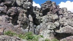
Basalt Bluff / Steve's Rock
Teton, Idaho
2.9 miles S of Teton, IdahoDon't go anywhere marked No Trespassing and Beware of the Attack Bees at the top of the cliffs and the Stinging Nettle at the bottom.
About a mile north of Loon Lake/Wentworth Springs Road junction, going towards Loon Lake, look up to the left to see this formation. Park on the road (narrow) and hike up to the the east face where all the climbs are. Can rappel off (2 ropes) or walk off to the north. Most routes are high quality with good rock. At last count there were 11 established routes here.
| Route | Difficulty | Ascents |
|---|---|---|
| 5.8 Hand Crack | 5.8 | 1 |
| Aoxomoxoa | 5.10b | 1 |
| Brown Shoes | 5.10c | 1 |
| Hangdogs Beget Eurodogs | 5.10a | 2 |
| Movin to Montana | 5.10c | 1 |
| Punk Titans Unchained | 5.10a | 1 |
| Three Ekka | 5.11a | 1 |
courtesy of RockClimbing.com

Sheep Falls on Henry's Fork
Island Park, Idaho
15.6 miles S of Island Park, IdahoSheep Falls is a beautiful, lesser-known waterfall on the Henry's Fork of the Snake River near Island Park, Idaho, where the river squeezes through a narrow basalt chute and drops about 25 feet in a churn of whitewater. It may be shorter than the famous Upper and Lower Mesa Falls just across the way, but it's every bit as scenic — and far quieter, making it a wonderful reward for a short, easy hike.
The trail to Sheep Falls is a gentle stroll of roughly a mile each way on a relatively well-maintained path, suitable for the whole family and rarely crowded. The route sits on the opposite side of the river from Mesa Falls, off Highway 20: head north past Ashton, turn onto Sheep Falls Road, and follow it to the trailhead — though be warned, the final dirt road is rough and rocky, so a high-clearance vehicle is a good idea.
There are calmer pockets near the falls where people wade and swim on hot summer days, but the water here deserves real respect. The current above and around the chute is powerful and can sweep you off your feet and pull you toward the drop. Stay well back from the lip, keep a close eye on children, and only consider getting in where the water is clearly calm and you know it's safe — when in doubt, enjoy the falls from the bank.
The best season runs roughly May through October, when the road is passable and the river is at its most beautiful. Bring sturdy shoes, water, and a camera, pack out everything you bring in, and you'll discover one of the Island Park area's most underrated natural treasures.

Fall Creek Falls
Swan Valley, Idaho
2.1 miles SW of Swan Valley, IdahoFall Creek Falls is one of eastern Idaho's most beloved and photographed waterfalls — a broad, 60-to-70-foot curtain of water that spills over mossy travertine ledges directly into the Snake River near Swan Valley. It's a genuinely unusual sight: most waterfalls tumble into a creek or pool, but this one pours straight into a major river, framed by the cottonwoods and canyon walls of the beautiful Swan Valley. It's especially glorious in autumn, when the riverside trees blaze gold and the whole scene lights up.
The best part for most visitors is how easy it is to reach. From Highway 26 just west of Swan Valley, turn onto gravel Fall Creek Road (Forest Road 058) and follow it along the Snake River to a small pull-out near the falls. From there it's more of a short walk than a hike — cross a small stream and stroll a couple of minutes to a flat perch right at the top of the falls, with sweeping views over the waterfall and the river beyond.
Adventurous visitors can scramble down for a closer look. A steep, sandy slide and a set of natural rock steps lead down toward the base, where you'll find a mossy grotto tucked behind and beneath the falls — a magical little chamber where you can stand in the cool mist and shade with the water curtaining down in front of you. The ceiling is low, so watch your head, and the rock steps kick up far less dust than the loose slide.
Be careful near the edges. The viewpoints at the top sit right above the falls, with abrupt, unrailed cliff drops of 10 to 15 feet in places, so keep well back from the lip and hold onto children — the rock can be slick near the water. The short scramble to the bottom is steep and can be slippery too.
The falls are a favorite of paddlers, too: because the water spills right into the Snake, kayakers and rafters floating this stretch below Palisades Dam can pull up close to the base for a view you can't get any other way. In winter the falls partially freeze into curtains and columns of ice, drawing photographers to the snowy canyon. However you come at it — on foot from the road above or by boat from the river below — it's a quick, high-reward stop between Idaho Falls and the Wyoming line.
The falls run year-round and reward a stop in any season, though flows are fullest with spring snowmelt and the color is best in fall. For photographers, midday sun is harsh out here; early morning or evening light is far kinder. Keep an eye on the river, too — boaters and rafters drift past below, and the area teems with wildlife, including the American white pelicans that cruise this stretch of the Snake. A Forest Service campground and public boat ramps sit nearby, making it easy to turn a quick stop into a longer stay. Bring water and sturdy shoes, and enjoy one of those “how have I never seen this before?” Idaho gems.

Packsaddle Lake
Tetonia, Idaho
9.3 miles W of Tetonia, IdahoPacksaddle Lake is a little-known gem tucked into the Big Hole Mountains west of Tetonia, Idaho — a small, cold, tree-ringed mountain lake with a rope swing, a hidden-away feel, and glimpses of the Tetons on the way in. It sees a fraction of the crowds of the more famous Teton-side lakes, which is a big part of its charm, but earning that solitude takes a rough drive and a steep little hike.
Getting there is the crux. The access road is genuinely rough — a high-clearance or four-wheel-drive vehicle is strongly recommended, and drivers of cars and minivans report needing some creative maneuvering to pick their way up. About 0.4 miles below the trailhead the road takes a steep, washed-out turn, and there are good pull-offs where you can simply park and walk the rest. From the upper trailhead it's a short but steep descent of around 300 feet in under half a mile down to the water; you'll spot the lake from the top of the trail, and switchbacks make the grade manageable.
At the lake you'll find a small camp area on the eastern shore and a rope swing out over the water — swing out far enough, since the lake shallows and drops off quickly near the edge, and the water is bracingly cold. It's a fun spot to swim, float (bring an inflatable if you can), picnic, and cool off after the hike in. Mountain bikers can also reach the lake by a longer, climbing singletrack from the lower trailhead that serves up beautiful Teton views before dropping to the water.
A few seasonal notes: the mosquitoes can be fierce up top in early summer (they ease off down by the lake), so bring repellent, and water levels drop as the season goes on. Snow lingers on the high road into early summer and returns in fall — more than one group has gotten a vehicle stuck in an early- or late-season snow squall up here.
The Big Hole Mountains that cradle the lake are a quieter, lower range just west of the Tetons, laced with trails and dotted with small lakes — a locals' playground for hiking, mountain biking, and hunting that rarely feels crowded. Packsaddle is one of its little treasures: a place to swing off the rope, float away an afternoon, cast for the occasional trout, or pitch a tent for a low-key overnight under the stars. On the drive and hike in, the reward is those signature Teton views rising to the east over the intervening ridges.
Come prepared for backcountry conditions: there are no facilities, so carry plenty of water, sun protection, and everything you'll need, and pack out all your trash. For those willing to brave the road, Packsaddle Lake is a rewarding, off-the-radar escape in the quiet Big Hole Mountains.

Table Rock / Table Mountain
Driggs, Idaho
10.0 miles E of Driggs, IdahoAt roughly 11,100 feet, the flat-topped summit of Table Mountain serves up what many consider the single finest view of the Grand Teton anywhere — and one of the great day hikes on the quiet, western (Idaho) side of the range. From the broad mesa top you stand just far enough back to take in all three Teton peaks at once, yet close enough to pick out the detail on the Grand's sheer east face across the deep gulf of the canyon. It's a jaw-dropping payoff, and a hard-earned one.
The mountain holds a remarkable place in history. In 1872, pioneering survey photographer William Henry Jackson hauled his heavy glass-plate camera gear by mule to the top of Table Mountain and made the first photographs ever taken of the Grand Teton — images that helped introduce the range to the wider world and build support for protecting it. Jackson chose this peak precisely because its gentle western slopes could be reached without technical climbing, and that's still what makes the summit attainable for strong day hikers today.
The trailhead sits at the end of Teton Canyon Road outside Driggs and Alta, and nearly the entire route lies within the Jedediah Smith Wilderness of the Caribou-Targhee National Forest. There are two main ways up, and both climb over 4,000 feet. The Face Trail is the steeper, shorter option (about 3.5 miles one way), skipping the switchbacks to head more or less straight up. The Huckleberry (North Fork) Trail is longer but far more gradual (about 6.5 miles one way), following and crossing the North Fork of Teton Creek — handy spots to filter water — through meadows and, in mid-to-late summer, ripe huckleberries for those who beat the crowds to the bushes. Many hikers link the two into a big loop of roughly 11–13 miles, and tough-but-knee-conscious hikers generally prefer to climb up the steep Face and come down the gentler Huckleberry, sparing their knees the pounding of a steep descent. The lower trail is a delight in its own right, tracing rushing Teton Creek past a string of waterfalls.
The wildflowers here are spectacular. As the snow recedes, Table Mountain's meadows erupt in color — sweeping displays of lupine, arrowleaf balsamroot, and Indian paintbrush, with columbine in the shadier pockets and delicate alpine blooms up high. In the Tetons the canyon meadows tend to peak from early-to-mid July, while the highest ground saves its show for late July into August; even when snow still blocks the upper trail, the lower meadows near the trailhead put on an easy, photogenic display. It's one of the finest wildflower hikes in the region.
This is high, exposed country, so plan accordingly. At over 11,000 feet the air is thin and the weather changes fast: afternoon thunderstorms build quickly over the peaks in summer, so start early and aim to be off the open summit by early afternoon. Table Mountain is enjoyed year-round — it's a popular snowshoe and backcountry-ski destination in the snowy months. If you're after dry summer hiking, though, know that you're likely to encounter snow on the upper mountain before mid-July: early-season snowfields often begin around 9,500 feet with larger patches up high, and the Huckleberry side can hold avalanche debris and downed trees until it melts out. It's frequently still passable with the right footwear — just come expecting it. Conditions are typically most reliably snow-free from about mid-July through September. It's also easy to lose the trail, especially on the descent, so pay attention to your route and carry a map or GPS. Keep an eye out for wildlife, too — moose are a common sight in the canyon, and the area is home to the occasional mountain lion.
Bring layers, sun protection, plenty of water (and a filter), and sturdy footwear for the long, steep grade. You can check current conditions on the webcams at tetoncam.com before you drive up. Backpackers sometimes camp in the meadows below the summit to catch the Grand at sunrise — an unforgettable sight — while following Leave No Trace and wilderness regulations. However you do it, Table Mountain earns its reputation: a leg-burning climb to a mesa in the sky, carpeted in wildflowers, with the Grand Teton filling the horizon just as it did for Jackson a century and a half ago.

Hell's Half Acre Lava Walk
Blackfoot, Idaho
25.6 miles N of Blackfoot, IdahoThe Lava Trails traverse the desert of the Snake River Plain through contorted landscapes created from multiple lava flows. These Hawaiian-type lava flows are associated with the stretching of the earth’s crust. Hell’s Half Acre lava flow erupted about 4,100 years ago and is 222 square miles or 162,000 acres. The lava flowed at 2,000 degrees Fahrenheit, had the consistency of molasses, and traveled at speeds up to 30 mph.Courtesy of blm.gov
Undeveloped trails offering scenic solitude; short 0.5 mile loop trail and a 4.5-mile trail to the main vent of the Hell’s Half Acre flow. Trails are primitive and marked with poles across lava. A fire ring and other amenities are located at the trailhead.Courtesy of blm.gov

17 Mile Cave
Idaho Falls, Idaho
16.1 miles W of Idaho Falls, IdahoSeventeen Mile Cave is an easy, family-friendly lava tube out on the volcanic plain about 17 miles from Idaho Falls, Idaho — the source of its name. Formed by the flowing lava of the Snake River Plain's volcanic past, the tube was left hollow when the molten rock drained away, leaving a tunnel you can walk right into. Its easy access and gentle floor make it one of the most popular beginner caves in eastern Idaho, drawing spelunkers from Idaho Falls and Rexburg alike.
The entrance sits just a few hundred feet from the highway, and the cave runs a little less than a quarter mile back. What sets Seventeen Mile Cave apart from most lava tubes is its floor: instead of the usual jumble of collapsed rock, much of it is smooth and nearly flat, which makes walking the length of the cave surprisingly easy. There's one main tunnel that's simple to follow — no real chance of getting lost — making it a great first caving trip for kids and newcomers.
At the far end, the quarter-mile passage finishes at a pair of small pools and a swampy area; it's difficult to push much beyond this point, so most explorers turn around here. Along the way, the cave stays cool and humid year-round no matter how hot the desert above, so it's a refreshing escape on a summer day — and a genuinely chilly one in the shoulder seasons.
Come prepared with the caving basics: bring at least two light sources per person (the cave is completely unlit), wear a jacket or extra layer for the cool interior, and put on sturdy, closed-toe shoes, since the floor is damp and can be slick near the pools. It's a short trip, but a headlamp that frees your hands makes it far more enjoyable.
The cave is one of many volcanic features scattered across this stretch of the Snake River Plain, a landscape built by ancient eruptions and riddled with tubes, cracks, and cinder cones. That makes it a natural first stop for local families and Scout groups getting into caving, and an easy add-on to a day of exploring the wider volcanic country around Idaho Falls. Bring a group — caves are always more fun, and safer, with company — and let someone know where you're headed.
One honest note: because it's so close to town and so easy to reach, Seventeen Mile Cave gets heavy traffic, and it shows — the walls carry a lot of graffiti and the floor collects litter. Do the cave a favor by packing out everything you bring (and maybe a bit extra), skipping the spray paint, and treating the place with respect, so this accessible little lava tube stays a fun introduction to caving for the next family that comes to explore.
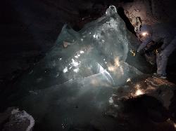
Rexburg Area Ice Caves
Rexburg, Idaho
29.1 miles N of Rexburg, IdahoNot to be mistaken with the Civil Defense Caves (which are near by), the Ice Caves are about an hour North outside of Rexburg. The Ice Caves were originally formed as lava tubes. The shape of the caves traps cold winter air in the cave and forms large areas of ice on the floor and beautiful ice crystals on the walls and ceiling. The ice remains frozen year round and makes for an awesome time. The ice caves are a few hundred yards deep and require good footwear, warm clothes and a flashlight to navigate. There is often a good amount of water near the entrance. There's a bridge of rocks across the area but you may get a little wet getting in the cave. There are areas where you'll need a rope to be able to ascend portions of ice. Please do not light fires or introduce any other heat source into the caves.

Fifth Water Hot Springs
Provo, Utah
19.0 miles SE of Provo, UtahFifth Water Hot Springs — better known to generations of Utahns as Diamond Fork Hot Springs — is one of the most beloved soaks in the state: a series of steaming, blue-green mineral pools tucked beside a waterfall in a pretty canyon southeast of Provo. A scenic drive up Diamond Fork Canyon and a riverside hike of about 2.5 miles each way lead to the reward, where hot water tumbles down a travertine hillside into a staircase of rock pools ranging from pleasantly warm to a toasty 105–110°F at the source.
The pools sit right where Fifth Water Creek meets a small waterfall, and part of the fun is choosing your spot. As you come into view of the falls you'll see a few pools perched just above the creek; more line the base of the waterfall, including shallow soakers and spots where you can nudge the rocks around to mix hot spring water with cool creek water and dial in your own temperature. Wander behind and beyond the waterfall and you'll find a couple of quieter, more secluded pools — just watch the slick, mineral-coated rock, which can be treacherously slippery. The water carries a faint sulfur smell and stains everything a milky blue-green; it's all part of the character.
A few practical notes make the trip smoother. There's nowhere private to change at the springs, so most people hike in their swimwear (and on a sunny day you'll dry off easily on the walk out). Bring water shoes or sandals if your feet are tender — the rocky pool bottoms and short scrambles are much friendlier with something on your feet. This is a relaxed, come-as-you-are place with a longstanding clothing-optional streak, so groups with kids may occasionally encounter suit-free soakers, especially on quiet weekdays.
Timing matters more here than at most hikes. The Diamond Fork Road gate closes for winter (typically from around November into late spring), and when it's shut the hike balloons to roughly 12–13 miles round trip — a popular but serious snowshoe or ski outing rather than a casual stroll. When the road is open, it's about a 5-mile round trip. Fall, winter, and spring are the sweetest seasons: cooler air makes the hot water far more inviting and the crowds thinner. The springs are busiest on weekends and holidays, so go early or midweek if you can, and note that a trailhead parking fee has been proposed for this popular spot, so come prepared for one.
Come prepared and tread lightly. Rattlesnakes are active along the sun-warmed trail in the warmer months — on a hot day you may well spot several snakes, most of them harmless, so simply watch where you step and reach. Carry plenty of drinking water — a long hot soak is dehydrating — and pack out everything you bring; broken glass and litter have been a real problem here, and keeping this gem clean is on all of us. Dogs are welcome on the trail. With a little planning, Fifth Water rewards you with one of the finest hot-spring soaks in the Wasatch — a waterfall at your back, canyon walls above, and warm mineral water swirling all around.

North Menan Butte ('R' Mountain)
Menan, Idaho
4.5 miles N of Menan, IdahoThe North Menan Butte is more commonly known to the locals and college students as R Mountain. Many kids know it better as Ou'R' Mountain. The butte is a rare and unique geological area and provides a great volcanic hike.
There's a paved parking lot and a vault toilet at the West trailhead. The first few hundred yards are well-maintained gravel and sand paths and the further you get, the less defined the trail gets, though it is relatively easy to find and follow. The switchback trails (South and West) are marked by sections of log fences. Towards the top of the West switchbacks, there's a chain handrail. It gets a little steep so you'll want some shoes with some grip. The sand on the rock makes it pretty slippery in the steeper parts. You'll get better grip after a good rain. Once you get up to the top, there's an informational placard. From there, it's easy to hike the rim and get an awesome view of the valley including Rexburg, Henry's Fork, and the Snake River.
It's a great hike for a small family or just a quick hike for a date. Even going up the West switchbacks and around rim, including the 'R', and back down the same way is only 3.5 miles (longest route) so you can do it pretty quick if you want. There's so much to look at that you could also spend hours climbing rocks, exploring caves, and playing around "The Ampitheater". If you just want to get to the 'R' as quickly as possible, you can do the hike in as little as 2 miles roundtrip.
Distances:
- West trailhead up the face to the rim: 0.5 miles
- West trailhead up the switchbacks to the rim: 0.75 miles
- West trailhead, from reaching the rim to 'R': 1 mile
- South trailhead to the rim: 0.3 miles
- South trailhead, from reaching the rim to 'R': 0.75 mile
- Through the caldera: 0.6 miles
- Around the rim: 2 miles
- Rim to 'R': 500 feet
There are no fees. Camping is allowed up to 5 nights but fires must be in an elevated fire pan and all the ash must be packed out.
Posted regulations:
- No motorized vehicle use
- Discharging of weapons or fireworks is prohibited
- Open fires are permitted only with an approved elevated fire pan and ash removal
- Burning pallets, tires, wire, plastic, glass, metal, magnesium, or hazardous material is prohibited
- Cutting or damaging vegitation is prohibited
- 5-day camping limit

Bitch Creek Trestle
Tetonia, Idaho
9.4 miles N of Tetonia, IdahoAs part of the Rails to Trails project, this old railroad bridge has been transformed into a very safe little viewing experience for the whole family. You can drive right up to the bridge where there is a great little spot to park. Bitch Creek meeanders hundreds of feet below the bridge.
The bridge is part of the 30 mile Ashton-Tetonia Trail. Conant Creek Pegram Truss Railroad Bridge is further down the same trail.
Difficulty: Beyond easy

Twin Bridges
St. Anthony, Idaho
6.6 miles NE of St. Anthony, IdahoTwin Bridges is a beloved bridge-jumping and swimming spot on the river near St. Anthony, Idaho — a summer institution for families, teens, and college students across the upper Snake River Valley. The name comes from the setup: an old abandoned bridge stands right beside the one still in use, and the deep, slow water beneath the old span makes for about the best bridge jumping around, with no traffic to dodge and easy parking nearby.
The jumping is the main event, and it's well suited to a range of nerve. There are two distinct levels to leap from — a lower point around 11 feet and a higher one around 17 feet — so you can start small and work your way up, and the water below is plenty deep for cannonballs, flips, and gainers. Locals consider it about as good and as “reasonably safe” as bridge jumping gets, with one firm caveat: keep clear of the rocks along the sides, which can be exposed depending on the water level.
There's more to it than jumping. A little rope swing often hangs under the bridge — a favorite of the little kids — and a path up the river makes a good put-in for a short, mellow float back down. For families with young children, there's a sandbar on the north side just upstream of the action, perfect for wading and splashing away from the jumpers. The slow current is ideal for simply hanging out in the water while you watch your friends show off.
A fun local curiosity: downstream of the little rock dam on the north side lie the sunken remains of an old car, washed here after an accident years ago. When the water is low and clear you can spot its chrome bumper from the rocks and swim down for a look — a quirky bit of underwater sightseeing that regulars love.
Part of the appeal is how welcoming and community-minded the spot is. Generations of upper-valley families and Rexburg-area college students have made Twin Bridges their go-to summer swimming hole, and there's a friendly, everybody-shares-the-water vibe on a busy afternoon. It's the kind of simple, free, small-town summer pleasure that keeps people coming back week after week.
A few practical notes: it's a popular place, so expect a crowd on hot, sunny days and holidays — though it handles a lot of people well, and you rarely wait long to jump. Bring water shoes for the rocky spots, sun protection, and drinking water, always check the water depth and clear your landing before jumping (levels change through the season), keep an eye on kids near the current, and pack out all your trash. For a classic, easygoing eastern-Idaho swimming hole, Twin Bridges is hard to beat.

Monkey Rock
Saint Anthony, Idaho
4.1 miles SE of Saint Anthony, IdahoMonkey Rock features a beautiful waterfall you can wade right up to during the summer. Just under the waterfall is a great spot to wade around in or even some shallow swimming pretty good for small children. Maybe you just want to take advantage of the great bank to bask in the summer sun. The water temperature is fairly cool, which by no means is unwelcomed during the hot summer months. You'll get used to the water fairly quickly once you're in. The waterfall is a fun feature at Monkey Rock, not to mention a popular engagement photo backdrop. The name "Monkey Rock" is derived from the "monkeys" who jump off the rocks at the top of the falls to the pool below. Though not a great height, it's important to be careful and only jump into areas clear of rocks and other hazards and where the water is deep enough that you won't hit bottom when you jump. There really isn't a safe spot to jump from the falls as it doesn't usually get more than 5 feet deep.
The real jumping location is off the Hog Hollow Bridge up the road from the waterfall.
PLEASE NOTE: On the roads leading to Monkey Rock, the speed limit is 35 mph for the last mile. There are kids, cows, horses, and dogs along that road and many people tend to speed going to and from Monkey Rock. Please slow down and stay safe.
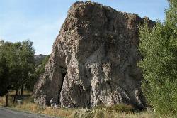
Heise Rock (AKA Elephant Rock)
Ririe, Idaho
5.0 miles E of Ririe, IdahoThis volcanic plug sits just off the road near the Heise Hot Springs Golf Course. It is also referred to as Elephant Rock or Chuck's Choss Pile. Aid climbers practiced on this small crag beginning in the early 1970s. With the birth of sport climbing in the '80s, Jeff Hursh started bolting some the most obvious lines on the south side. When Chuck Oddette moved to Idaho Falls in the late '80s, he immediately saw the great potential for numerous lines and quickly went to work developing Heise Rock.

Paramount Wall / Blanche Rock
Ririe, Idaho
6.1 miles E of Ririe, IdahoSitting high above the road, the routes at Paramount offer great exposure and relief from the afternoon summer sun. Chuck Oddette, Steve Reiser and Jed Miller established the routes from 1989 to 1990. While not the hardest climbing around, Paramount is home to great lines in the 5.9 - 5.10 range a perfect place for the budding lead climber. All routes except Fly By Night, Positively Negative, and Spraypaint can be done with a 50-meter rope.
Courtesy of SEIClimbing.com


