


28.4K 10 Year Anniversary by endovereric
first prev 1 next lastMy wife is awesome. Our marriage is awesome. This trip that she planned for us was awesome. 10 years of awesome...and counting!
We traveled down through Utah into California. We stayed in San Diego for a few days, then did a day in LA, a day in San Francisco, and a day in Yosemite. We even hit some hot springs on the way home.
Two nights were in a motel, the rest were in our minivan RV. We even slept on Neptune Drive, Mission Bay, and at Battery Spencer above the Golden Gate Bridge.
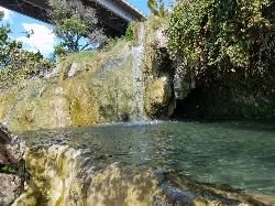
Little Jamaica aka Desert Springs
Littlefield, Arizona
0.8 miles NE of Littlefield, ArizonaLittle Jamaica, also known as Desert Springs or Littlefield Springs, was for years one of the most beloved little swimming holes in the Arizona Strip, a surprising desert oasis along the Virgin River near Littlefield, Arizona, about a 30-minute drive from St. George. A short quarter-mile walk led to a man-made pool fed by a warm mountain spring, with small waterfalls trickling through a lush pocket of green in the stark desert landscape. It earned its nickname for that unexpectedly tropical feel, and it was a favorite quick escape for students and families from St. George and Mesquite.
The important thing to know now is that Little Jamaica is closed. As of May 2022, the Arizona Department of Transportation closed off access to the area below where the man-made pool sat, and the swimming hole itself appears to have been dismantled. If you've come across older guides or videos showing the oasis and its waterfalls, this is the update that matters: it is no longer an open, accessible destination, and the pool that made it special is gone.
We're keeping this listing to make that status clear rather than to send anyone down to a closed site. Please respect the ADOT closure and do not trespass to reach it. Beyond the access issue, the setting always carried its own hazards, slippery, algae-slicked rock around the spring and pool, and the closure removes any safe, legal way to enjoy it.
The history is worth remembering fondly. Fed by a genuine mountain spring emerging into a built pool along the Virgin River, Little Jamaica was a rare desert water feature, cool and green amid red rock and creosote, close enough to the freeway to be an easy after-class or after-work stop. For a long time it was one of those word-of-mouth local treasures that made the Arizona Strip feel full of secrets.
For visitors still hoping to find water in this corner of the desert, the wider region offers legitimate, open alternatives: the developed and dispersed recreation along the Virgin River Gorge, the water features and parks around St. George and Mesquite, and the many open swimming and hiking spots of nearby southern Utah. Seeking those out is a far better plan than making the trip to a dismantled, closed site.
Treat Little Jamaica as a closed chapter, a fondly remembered desert oasis that is, for now, off the map. Respecting the closure is the right call, and it keeps the focus on the many places in the region that are still open, still watered, and still worth the drive.
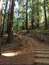
Muir Woods National Monument
Mill Valley, California
1.9 miles W of Mill Valley, CaliforniaMuir Woods National Monument is one of the great natural cathedrals of California, a hushed grove of ancient coast redwoods tucked into a fog-cooled canyon just 12 miles north of the Golden Gate Bridge near Mill Valley. Part of the Golden Gate National Recreation Area, its 554 acres protect 295 acres of old-growth redwood forest, where wooden footpaths wind between towering trees, many of them 600 to 800 years old and soaring up to 250 feet, along the banks of Redwood Creek. It is a genuinely awe-inspiring place, and one of the most beloved parks in the Bay Area.
The forest is the whole experience. Walking beneath these giants, in the cool green light filtering through the canopy with the creek murmuring alongside, is unlike anywhere else so close to a major city. The park offers about six miles of trails, from easy half-hour loops to more challenging routes that climb out of the canyon and connect with Mount Tamalpais State Park. The Main Trail is paved and wheelchair-accessible for its first mile, running level alongside Redwood Creek, which makes the heart of the grove reachable for just about any age or ability.
The single most important thing to know before visiting is that reservations are required. Because parking and the shuttle are limited and the park is enormously popular, you must reserve a parking spot or a shuttle seat in advance; you cannot simply drive up and get in. There is also an entrance fee (children are free), a standard national-park charge. Booking ahead through the official reservation system is non-negotiable, and it's the difference between a magical morning and being turned away at the road.
Muir Woods is open 365 days a year and opens at 8 a.m., and the early birds are rewarded: the first hours bring the best light for photos, the quietest trails, and the classic redwood-forest fog before the crowds arrive. It gets genuinely busy by midday, so an early reservation is the move.
The coastal climate means it's cool and often damp year-round, even when the rest of the Bay Area is warm, so layers and a rain shell are wise in any season. The paved main loop is stroller- and wheelchair-friendly; the connecting trails into the hills are steeper and rougher.
Come with warm layers, comfortable shoes, a camera, and, above all, a reservation made in advance. For a walk among 800-year-old giants in a fog-wrapped canyon minutes from San Francisco, Muir Woods is a bucket-list experience that fully earns its fame.
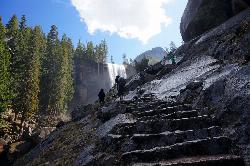
Mist Trail
Yosemite National Park
9.2 miles S of Yosemite National ParkThe mist trail is a small breakoff from the John Muir Trail through Yosemite National Park. It's called the mist trail because of the heavy amount of mist that hikers walk through as Vernal and Nevada Falls crash hundreds of feet below. The hike is short as for horizontal distance traveled but the incline will give you a run for your money. You'll ascend 639 stone stairs to reach the top of Vernal Falls. There's a waterfall in between the two that is a sight all it's own but is often forgotten because of the behemoths on either side. The hike between the falls is a nice break as it is fairly flat relative to the rest of the trail. Once you get to the base of Nevada Falls, you'll have to take switchbacks up the giant cliffs to the top.
These waterfalls are usually the last to dry up around Yellowstone Village. Whether you just love waterfalls or you want a closer view of Halfdome, Whitecap, or Mt. Broderick, the Mist Trail definitely offers world class views. There are bathroom facilities just above Vernal Falls and water just before you start to ascend the stairs. There's another trail that is less steep but that skips Vernal Falls.
Distances (one-way):
| Hike | Distance | Elevation Gain |
|---|---|---|
| Vernal Fall Bridge | 0.8 miles | 400 ft |
| Top of Vernal Falls | 1.5 miles | 1100 ft |
| Top of Nevada Falls | 3.4 miles | 2230 ft |
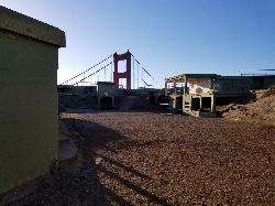
Battery Spencer
Mill Valley, California
6.3 miles SE of Mill Valley, CaliforniaThis is easily one of the best places to view the Golden Gate Bridge. For over half a century, this was one of the most strategically important sites guarding the Golden Gate. Completed in 1897, the battery was named for Joseph Spencer, who had been a Major General in the army during the American Revolution. It was armed with 3 rifled guns having 12" diameter barrels. The fortification saw continuous service until 1943, when it was declared obsolete and its guns scrapped.
Distance: 0.2mi each way
Riverside Walk
Springdale, Utah
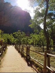
7.6 miles N of Springdale, UtahThe Virgin River has many moods, from quiet and slow to a raging torrent. This beautiful, shaded walk meanders through forested glens, following the path of the stream ever deeper into the canyon.
This trail passes through Zion's unique desert swamp environment, a wet, green oasis in this generally arid country. Look for hanging gardens on the cliffs by the trail. The paved trail ends at the river, but if you are prepared to get your feet wet, and if conditions permit, you may be able to continue up into The Narrows. Always check at the visitor center for current conditions before venturing into The Narrows. Flash floods can be deadly.
The paved trail is mostly flat and accessible. Wheelchairs may have some difficulty on short steep grades. Wear sturdy boots when hiking in the riverbed beyond the end of the trail. Loose stones and wet, slippery conditions make for treacherous footing.
Roundtrip: 1.5 hours / 2 miles
Elevation Gain: 57 feet
Weeping Rock
Springdale, Utah
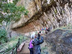
6.6 miles NE of Springdale, UtahExpect to get wet on this short hike! Weeping Rock gets its name from the continuous "weeping" of water that seeps through sandstone and drips from the cliffs above. Seasonal flowers brighten the hanging gardens and you'll find views of the Great White Throne and Angels Landing.
The trail is a short but steep walk with a few minor drop-offs. Best experienced while hiking at a leisurely pace, it is too steep in places for wheelchair access.
Weeping Rock Trail climbs through forest to a natural alcove eroded into the cliffside. Here perpetual springs nurture lush vegetation. This is a relatively accessible example of a "hanging garden".
Experience Zion's refreshing springs up close. The Navajo Sandstone cliffs hide pure water. The water travels slowly through the porous rock layer until it reaches the bottom and hits the less-permeable Kayenta layer. Like reaching a geologic stop sign, the water is forced out of the cliff face as as natural spring. Where water seeps out, you will find surprising hanging gardens in the desert. Look for maidenhair ferns and flowers in the spring.
Difficulty: Easy
Roundtrip: 0.5 hours; 0.4 miles
Elevation Change: 98 feet


