


942 Yosemite Hikes by smbrady17
first prev 1 next last
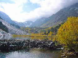
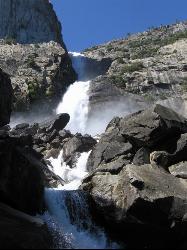
Glen Aulin
Glen Aulin, California
0.3 miles SE of Glen Aulin, CaliforniaThis trail is a popular route to take in the Yosemite High Country because it is a good introductory hike into the backcountry. At the end of the hike there are several waterfalls as well as a High Sierra Camp to stay at. This can be done as a day hike to the High Sierra Camp, and visitors can then enjoy a good meal and a nice tent. If hikers do not wish to pay the fee for the meal service/provided tent, there are several backpacker campsites throughout the site as well.
The majority of the trail will follow the Tuolumne River as it meanders through the Tuolumne Meadows and up into the High Sierra. Once reachingn the Glen Aulin camp, the beautiful White Cascade waterfall will be right next to the camp. Most visitors will use this camp as a basecamp for their adventures because the area has so many cool places to explore. One area that is popular to go to is Waterwheel Falls, which passes through a unique granite canyon. Outside of the camp and part of a different day hike is a trip to the Grand Canyon of the Tuolumne. Many people will also enjoy a quick swim in the river, depending on how swift the current is.
There is plenty of wildlife to see, especially when the trails first open. Usually the trail will be open once road access is cleared to Tuolumne Meadows. Because of elevation, the flowers will bloom later than flowers found in Yosemite Valley. Also due to elevation, the High Country will be much cooler during the summer than in most places in the park.

Mist Trail
Yosemite National Park
9.2 miles S of Yosemite National ParkThe mist trail is a small breakoff from the John Muir Trail through Yosemite National Park. It's called the mist trail because of the heavy amount of mist that hikers walk through as Vernal and Nevada Falls crash hundreds of feet below. The hike is short as for horizontal distance traveled but the incline will give you a run for your money. You'll ascend 639 stone stairs to reach the top of Vernal Falls. There's a waterfall in between the two that is a sight all it's own but is often forgotten because of the behemoths on either side. The hike between the falls is a nice break as it is fairly flat relative to the rest of the trail. Once you get to the base of Nevada Falls, you'll have to take switchbacks up the giant cliffs to the top.
These waterfalls are usually the last to dry up around Yellowstone Village. Whether you just love waterfalls or you want a closer view of Halfdome, Whitecap, or Mt. Broderick, the Mist Trail definitely offers world class views. There are bathroom facilities just above Vernal Falls and water just before you start to ascend the stairs. There's another trail that is less steep but that skips Vernal Falls.
Distances (one-way):
| Hike | Distance | Elevation Gain |
|---|---|---|
| Vernal Fall Bridge | 0.8 miles | 400 ft |
| Top of Vernal Falls | 1.5 miles | 1100 ft |
| Top of Nevada Falls | 3.4 miles | 2230 ft |
Lundy Canyon
Bridgeport, California
16.2 miles S of Bridgeport, CaliforniaIn just one 3 mile hike, Lundy Canyon provides views of waterfalls, meadows, mountains, and if you're up for it, a trip to the Twenty Lakes Basin.
There is much to take in even after going just .5 miles. The trail first takes you through a grove of trees and past a beaver pond until you reach the lower Lundy Canyon Falls. These twin waterfalls stand at 70 feet high and are easily seen from the trail, although it is isn't an up close and personal look. Once you pass the waterfalls, you enter the Hoover Wilderness.
The trail gets a little less straightforward after this point. Head west for a 2,000 ft climb up to Burro Lake, which sits at an altitude of 10,551 feet, or head east for something slightly more tame. This trail will take you through some of Lundy Canyon's famous wildflower meadows and straight to the base of the second set of falls in the canyon. Mill Creek drops off in four separate cascades that total about 100 feet. Starting from the base of the falls and climbing upward, the trail begins to get more difficult. A series of switchbacks takes you past one more waterfall, out of the canyon and to the Twenty Lakes Basin.

Hite Cove Trail
El Portal, California
5.8 miles W of El Portal, CaliforniaThis hike is popular among wildflower enthusiasts. Located in Yosemite National Park, Hite Cove trail is one of the areas that blooms earliest for wildflowers. While areas in the high country usually don't see complete snowmelt and wildflower blooming until July, Hite Cove offers park visitors the opportunity beginning earlier in the season.
If visitors just want to walk around and see the flowers, the trail can be about 2-4 miles round trip. However, if they want to go all the way to Hite Cove, it is about a 9 mile round trip hike. Along the way hikers will be able to see where the south and central fork of the Merced River merge and continue until the Pacific. There is not one single spot along the trail that is the most popular. Because of this, there might be a lot of people on the trail but they will be spread out along the trail, making for less congestion. If only going to see the wildflowers, then hikers can turn around at any point in time. About 2 miles into the trail there won't be any new types of wildflowers to see, so feel free to turn around at any time.
Hite Cove used to be a seasonal home to the Ahwahneechee Native Americans and later to a group of gold miners. All artifacts found along the trail and in Hite Cove should remain where they were found.

Glacier Point
Yosemite National Park
9.6 miles S of Yosemite National ParkLocated in Yosemite National Park, Glacier Point gives a birds-eye-view of the park you can't find anywhere else. It can be accessed by both hiking and driving through the park, though the roads may be closed until early to late May due to snow. Glacier Point towers over Yosemite Valley, sitting at 7,214 ft compared to the 4,000 ft valley floor.
From Glacier Point visitors are able to see the famous Half Dome, Vernal Falls, Nevada Falls, Yosemite Falls, El Capitan, and the Yosemite High Country. Each season offers a different view and feel for visitors. Come in the winter and you will see a snow covered Half Dome and High Country. Spring comes with the promise of new green leaves and roaring, snowmelt fed waterfalls. The summer still offers plenty of views, though a lot of tourists will be visiting. Fall brings a change of leaves throughout the park, and so it provides a beautiful contrast to the granite cliffs all around.
The trails to get to Glacier Point are the Four Mile Trail and the Panoramic Trail. The Four Mile Trail starts at the valley floor and like the name says, it is about 4.7 miles one way. Hiking up to Glacier Point has a significant level of elevation gain (Valley Floor is 4,000 ft and Glacier Point is 7,214 ft). The trail offers views of the Yosemite Valley that belong in a postcard. Those who hike to the top can enjoy an ice cream at the general store, while taking in the views. On the way down, hikers will see Yosemite Falls constantly in front of them, while the other sights of the valley floor come into view as the trail descends.
The Panoramic Trail is an alternative for going down from Glacier Point. Many hikers alternate between taking the Four Mile Trail up and the Panormaic Trail down (or vice versa). While the sights of the Four Mile Trail include many of the valley floor sights, the Panoramic Trail offers views of Illilouette, Nevada, and Vernal Falls. The trail ends at a different point than the Four Mile Trail, but hikers can take one of the free shuttles throughout the park.
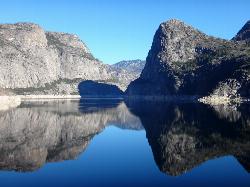
Hetch Hetchy Reservoir
Groveland, California
25.5 miles E of Groveland, CaliforniaLocated thirty minutes outside Yosemite Valley, Hetch Hetchy has the longest hiking season in the park. It's home to the O'Shaughnessy Dam and Wapama Falls.
Since the O'Shaughnessy Dam was built in 1978, the Hetch Hetchy reservoir holds 117 billion gallons of water provides drinking water for the Bay Area residents.
Wapama Falls is one of the lesser known waterfalls in Yosemite, but the hike offers amazing views of the reservoir and takes you straight across the dam and through a tunnel to a footbridge at the base of the falls, almost ensuring that you'll get sprayed.
There are several day hikes available in Hetch Hetchy, including Lookout Point, Wapama Falls, Rancheria Falls, Smith Peak, and Poopenaut Valley.
At 7,751 ft, Smith Peak is the tallest point in the Hetch Hetchy area. There are two trailheads that both begin at the entrance. One trail is 13 miles roundtrip, and the other is 16 miles roundtrip, but they are both fairly strenuous.
Many people who visit Hetch Hetchy enjoy the peace and serenity offered there, because there is no boating or swimming allowed in the reservoir. Fishing is permitted, but fishers are not allowed to catch anything larger than 12 inches, no more than two trout per day, and only artificial lures are permitted in the O'Shaughnessy Dam area.
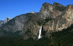
Bridalveil Falls
Yosemite Valley, Yosemite National Park
3.5 miles SW of Yosemite Valley, Yosemite National ParkKnown for being the focal point for one of Ansel Adams' most famous photographs, Bridalveil Falls is one of the first waterfalls you see as you enter Yosemite. The path to get there is a quick, easy half mile hike, making it a great introduction to the park. It gets its name from the mist that rises up from the falls and usually soaks onlookers -- it resembles a bride's veil. Although it's not as tall as Yosemite Falls (no North American waterfall is), it still towers over the valley at 620 feet tall.
The trail is pretty simple. You can park outside the trailhead to a paved path that will take you to the viewing point, but it goes straight through a range of trees. It's easy to navigate once you're there, but difficult to make out on a map.
Although it is one of the few that flows year round, the water from the falls is at its peak in the spring and summer, where it's likely you will get wet from the viewing point, and in the winter, the path can get pretty icy and slippery. The trail is completely paved, so it is wheelchair accessible and pets are permitted as long as they're on a leash.
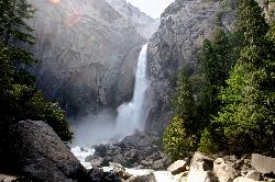
Lower Yosemite Falls
Yosemite Valley, Yosemite National Park
0.2 miles W of Yosemite Valley, Yosemite National ParkYosemite Falls is 3,967 feet high, making it twice as tall as the Empire State building, ten times as tall as Niagara Falls, and one of Yosemite Valley's biggest attractions.
Lower Yosemite Falls trail is short, easy hike that offers views of the entirety of North America's tallest waterfall from its base. The trail is so short and flat that it's essentially just a brisk walk. It will lead you to a footbridge where you will likely get sprayed with water if you are visiting during spring or early summer. By early fall and late summer, though, the waterfall will dry up, so make sure you plan accordingly.
Although the hike doesn't offer much until you reach the falls, there are several places to stop, rest, and read about the history and significance of the iconic waterfall.
Once you've admired the waterfall, taken tons of photos and gotten completely soaked, you can cross a bridge over Yosemite Creek to loop back to the shuttle stop or make your way east, past Yosemite Village toward Mirror Lake, a popular pool a couple miles away.
Rainbows can sometimes form at the base of the lower falls when the moon is full, a phenomenon called "moonbows."

Cook's Meadow Loop
Yosemite Valley, Yosemite National Park
0.0 miles E of Yosemite Valley, Yosemite National ParkCook's Meadow Loop is a shorter, smaller hike inside Sentinel Meadow. Cook's Meadow Loop is just under a mile and takes about 45 minutes to complete, depending on how long you stop at each viewpoint.
Yosemite Falls, Half Dome, Glacier Point and Sentinel Rock are just a quick walk along Cook's Meadow Loop. There is almost no elevation gain, making it one of the easiest trails in the park with multiple views of some of Yosemite's most well-known attractions. It's a great place for first-time visitors to start their Yosemite exploration.
The trail takes you directly past Sentinel Bridge, which is one of the most popular viewpoints to see Half Dome and is often crowded with photographers once sunset hits.
Cook's Meadow is right around the corner from the Lower Yosemite Falls trailhead, which is just an extra .5 mile and offers an even closer look at Lower Yosemite Fall.
Bathrooms and a variety of food options are available at Yosemite Lodge, just past the trailhead. Once you've finished the hike, you can grab a bite to eat at its food court, Coffee Corner or The Mountain Room, their full-service restaurant.
Cook's Meadow offers some of the greatest views in the park without having to take a very strenuous hike, making it enjoyable for everyone who visits.
Wapama Falls
Groveland, California
25.3 miles E of Groveland, CaliforniaA 5 mile hike along the shoreline of the Hetch Hetchy reservoir will take you to one of Yosemite's famous waterfalls. The hike to the fall is moderate, takes about 2.5-5 hours to complete and offers views of Tueeulala, mountains and the reservoir.
Wapama Falls currently stands at 1000 ft, but it was an extra 400 ft taller before the dam was built. Once the water raised from the dam, the bottom of Wapama Falls became engulfed into the Hetch Hetchy Reservoir.
This hike is one of the most engaging hikes in Yosemite. Walk over a bridge to cross the O'Shaughnessy Dam, go through a short tunnel, and prepare to get sprayed by the falls. Though the hike is along the reservoir, boating and swimming is not permitted, which adds to the solitude and peacefulness of the hike. There is a bridge at the bottom of Wapama Falls that offers different viewpoints of the falls, the Hetch Hetchy reservoir, and the O'Shaughnessy Dam, but it's possible for the water to get high enough to flow over the bridge after particularly wet winters.
Because of the power of the raging waters, Wapama Falls trail stays closed throughout the winter and early spring. Even once the trail is open, it is still possible the water may be too high, flooding the bridge and making it dangerous and impassable. Later in the season is the best time to visit because the water is low enough to make crossing the bridges and exploring the reservoir safe. The hike to see Wapama Falls is a relatively short trail that offers some of the most amazing views of a part of Yosemite few people take the time to visit.


